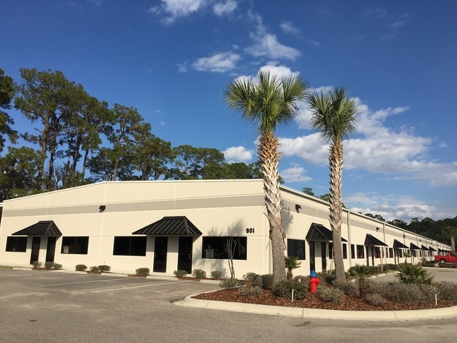
Property Record
901 S Charles Richard Beall Blvd, Debary, FL 32713


Current Lease Availabilities
NEARBY LISTINGS FOR SALE OR LEASE
Property Detail
901 S Charles Richard Beall Blvd
Deltona-Daytona Beach-Ormond Beach, FL
Osteen Sub Mb
9016-01-00-0040
16-19-30 LOT 3 E A OSTEEN SUB MB 4 PG 140 MB 16 PG 119 SUB OF GOV LOT 2 EXC N 66 FT & EXC S 212.78 FT OF E 654.24 FT & EXC ROW FOR SR 15/600 FURTHER EXC W 256.26 FT PER OR 4893 PG 3994 PER OR 5440 PGS 2951-2953 INC PER OR 7065 PG 4059 PER OR 7188 PG
Lightindustrial
Volusia
X
Florida
12127C0730H
3,2
2025
4.27 AC
2026
Deltona
090906
Deltona/Daytona Beach
52,050 SF
DEMOGRAPHICS near 901 S Charles Richard Beall Blvd
1 Mile
3 Mile
5 Mile
2024 Total Population
295
27,632
99,702
2029 Population
326
29,816
106,893
Pop Growth 2024-2029
+ 10.51%
+ 7.90%
+ 7.21%
Average Age
42
38
40
2024 Total Households
110
10,758
38,897
HH Growth 2024-2029
+ 10.00%
+ 8.12%
+ 7.35%
Median Household Inc
$127,885
$71,638
$70,164
Avg Household Size
2.60
2.50
2.50
2024 Avg HH Vehicles
3.00
2.00
2.00
Median Home Value
$410,294
$322,719
$289,718
Median Year Built
2004
2003
1997
Nearby Places
Map Layers
Map Styles
 Street
 Aerial
- Restaurants
- Banks
- Shops
- Fitness
- Groceries
PUBLIC TRANSPORTATION
COMMUTER RAIL
Debary (SunRail - Florida Department of Transportation)
DRIVE
WALK
Distance
Debary (SunRail - Florida Department of Transportation)
2 min
17 min
0.9 mi
Sanford (SunRail - Florida Department of Transportation)
DRIVE
WALK
Distance
Sanford (SunRail - Florida Department of Transportation)
9 min
5.1 mi
AIRPORT
Orlando Sanford International
DRIVE
WALK
Distance
Orlando Sanford International
20 min
10.3 mi
Daytona Beach International
DRIVE
WALK
Distance
Daytona Beach International
40 min
31.2 mi
Orlando International
DRIVE
WALK
Distance
Orlando International
50 min
38.6 mi
Freight Ports
Port Canaveral
DRIVE
WALK
Distance
Port Canaveral
86 min
71.6 mi
Nearby Properties
Address
Land Use
TOTAL SIZE
Lot Size
Zoning
Address
Land Use
TOTAL SIZE
Lot Size
Zoning
1,096 SF
22.55 AC
PUD
Address
Land Use
TOTAL SIZE
Lot Size
Zoning
36.94 AC
A1
Address
Land Use
TOTAL SIZE
Lot Size
Zoning
18,728 SF
22.36 AC
Address
Land Use
TOTAL SIZE
Lot Size
Zoning
425,407 SF
19.88 AC
Address
Land Use
TOTAL SIZE
Lot Size
Zoning
600 SF
20.98 AC
PD
Address
Land Use
TOTAL SIZE
Lot Size
Zoning
312 SF
10.47 AC
Address
Land Use
TOTAL SIZE
Lot Size
Zoning
24,382 SF
18.45 AC
A1
Address
Land Use
TOTAL SIZE
Lot Size
Zoning
381,678 SF
15.85 AC
Address
Land Use
TOTAL SIZE
Lot Size
Zoning
250 SF
14.29 AC
RMOI
Address
Land Use
TOTAL SIZE
Lot Size
Zoning
2.42 AC
A1
Address
Land Use
TOTAL SIZE
Lot Size
Zoning
1,001 SF
12.02 AC
MR3
Address
Land Use
TOTAL SIZE
Lot Size
Zoning
245,806 SF
24.93 AC
RMOI
Address
Land Use
TOTAL SIZE
Lot Size
Zoning
140,141 SF
6.73 AC
Address
Land Use
TOTAL SIZE
Lot Size
Zoning
410,197 SF
0.75 AC
PUD
Address
Land Use
TOTAL SIZE
Lot Size
Zoning
492,285 SF
19.58 AC
PD
Address
Land Use
TOTAL SIZE
Lot Size
Zoning
110,310 SF
19.33 AC
PD
Address
Land Use
TOTAL SIZE
Lot Size
Zoning
9.54 AC
M1
Address
Land Use
TOTAL SIZE
Lot Size
Zoning
180,500 SF
13.03 AC
PCD
Address
Land Use
TOTAL SIZE
Lot Size
Zoning
211,011 SF
25.54 AC
PD
Address
Land Use
TOTAL SIZE
Lot Size
Zoning
9,460 SF
208.56 AC
Address
Land Use
TOTAL SIZE
Lot Size
Zoning
19.57 AC
PD
Address
Land Use
TOTAL SIZE
Lot Size
Zoning
167,119 SF
16.93 AC
PD
Address
Land Use
TOTAL SIZE
Lot Size
Zoning
100,371 SF
25.19 AC
PCD
Address
Land Use
TOTAL SIZE
Lot Size
Zoning
166,579 SF
6.15 AC
Address
Land Use
TOTAL SIZE
Lot Size
Zoning
158,247 SF
1,708.99 AC
Address
Land Use
TOTAL SIZE
Lot Size
Zoning
143,421 SF
11.90 AC
PD
Address
Land Use
TOTAL SIZE
Lot Size
Zoning
2.21 AC
GC2
Address
Land Use
TOTAL SIZE
Lot Size
Zoning
148,697 SF
11.44 AC
RI1
Address
Land Use
TOTAL SIZE
Lot Size
Zoning
112,230 SF
9.05 AC
PCD
Address
Land Use
TOTAL SIZE
Lot Size
Zoning
204,618 SF
11.92 AC
PD
The World's #1 Commercial Real Estate Marketplace
Connect with us
© 2026 CoStar Group
The information above has been obtained from sources believed reliable. While we do not doubt its accuracy we have not verified it and make no guarantee, warranty or representation about it. It is your responsibility to independently confirm its accuracy and completeness. Any projections, opinions, assumptions, or estimates used are for example only and do not represent the current or future performance of the property. The value of this transaction to you depends on tax and other factors which should be evaluated by your tax, financial, and legal advisors. You and your advisors should conduct a careful, independent investigation of the property to determine to your satisfaction the suitability of the property for your needs.