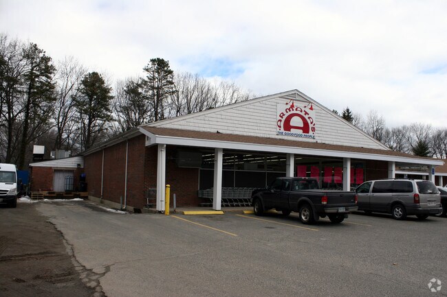
Property Record
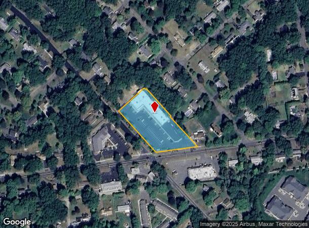
901 Shaker Rd, Longmeadow, MA 01106
Current Lease Availabilities
NEARBY LISTINGS FOR SALE OR LEASE
Property Detail
901 Shaker Rd
LONG-000645-000174-000044
Hampden
Regionalshoppingcenterormallwithanchorstore
Massachusetts
X
44
25013C0416E
1.78 AC
2025
Hampden County
2025
Hartford
813304
Springfield, MA
17,426 SF
DEMOGRAPHICS near 901 Shaker Rd
1 Mile
3 Mile
5 Mile
2024 Total Population
5,864
39,612
136,482
2029 Population
5,768
39,160
134,521
Pop Growth 2024-2029
(1.64%)
(1.14%)
(1.44%)
Average Age
45
43
41
2024 Total Households
2,407
14,393
51,454
HH Growth 2024-2029
(1.62%)
(1.36%)
(1.60%)
Median Household Inc
$108,284
$100,671
$73,582
Avg Household Size
2.40
2.50
2.40
2024 Avg HH Vehicles
2.00
2.00
2.00
Median Home Value
$294,112
$283,081
$262,220
Median Year Built
1962
1959
1957
Nearby Places
Map Layers
Map Styles
 Street
 Aerial
- Restaurants
- Banks
- Shops
- Fitness
- Groceries
PUBLIC TRANSPORTATION
COMMUTER RAIL
DRIVE
WALK
Distance
13 min
6.6 mi
AIRPORT
Bradley International
DRIVE
WALK
Distance
Bradley International
30 min
12.4 mi
Nearby Properties
Address
Land Use
TOTAL SIZE
Lot Size
Zoning
Address
Land Use
TOTAL SIZE
Lot Size
Zoning
236,616 SF
31.07 AC
RA1
Address
Land Use
TOTAL SIZE
Lot Size
Zoning
69.62 AC
MFHD
Address
Land Use
TOTAL SIZE
Lot Size
Zoning
370.78 AC
R88
Address
Land Use
TOTAL SIZE
Lot Size
Zoning
283.30 AC
R88
Address
Land Use
TOTAL SIZE
Lot Size
Zoning
166,268 SF
36.70 AC
R44
Address
Land Use
TOTAL SIZE
Lot Size
Zoning
232,510 SF
61.40 AC
RB
Address
Land Use
TOTAL SIZE
Lot Size
Zoning
142,872 SF
57.41 AC
INDG
Address
Land Use
TOTAL SIZE
Lot Size
Zoning
8,712 SF
25.08 AC
RA1
Address
Land Use
TOTAL SIZE
Lot Size
Zoning
9.69 AC
B
Address
Land Use
TOTAL SIZE
Lot Size
Zoning
500,000 SF
71.20 AC
I-1
Address
Land Use
TOTAL SIZE
Lot Size
Zoning
121.07 AC
I-1
Address
Land Use
TOTAL SIZE
Lot Size
Zoning
84,605 SF
13.15 AC
RB
Address
Land Use
TOTAL SIZE
Lot Size
Zoning
65.52 AC
BR
Address
Land Use
TOTAL SIZE
Lot Size
Zoning
62,548 SF
10.50 AC
R1
Address
Land Use
TOTAL SIZE
Lot Size
Zoning
49.16 AC
I-1
Address
Land Use
TOTAL SIZE
Lot Size
Zoning
36.97 AC
I-1
Address
Land Use
TOTAL SIZE
Lot Size
Zoning
211,256 SF
41.58 AC
R33
Address
Land Use
TOTAL SIZE
Lot Size
Zoning
121 AC
A-1
Address
Land Use
TOTAL SIZE
Lot Size
Zoning
513,160 SF
38 AC
INDG
Address
Land Use
TOTAL SIZE
Lot Size
Zoning
53,298 SF
7.23 AC
PRO
Address
Land Use
TOTAL SIZE
Lot Size
Zoning
183,248 SF
4.47 AC
R4
Address
Land Use
TOTAL SIZE
Lot Size
Zoning
57,328 SF
11.15 AC
INDG
Address
Land Use
TOTAL SIZE
Lot Size
Zoning
154,126 SF
9.27 AC
Address
Land Use
TOTAL SIZE
Lot Size
Zoning
103,324 SF
20.47 AC
RA1
Address
Land Use
TOTAL SIZE
Lot Size
Zoning
31,389 SF
9.45 AC
R1
Address
Land Use
TOTAL SIZE
Lot Size
Zoning
13.78 AC
BR
Address
Land Use
TOTAL SIZE
Lot Size
Zoning
44,824 SF
10.74 AC
RA-2
Address
Land Use
TOTAL SIZE
Lot Size
Zoning
19.36 AC
BR
Address
Land Use
TOTAL SIZE
Lot Size
Zoning
144,625 SF
19 AC
BR
Address
Land Use
TOTAL SIZE
Lot Size
Zoning
11.51 AC
RA1
The World's #1 Commercial Real Estate Marketplace
Connect with us
© 2026 CoStar Group
The information above has been obtained from sources believed reliable. While we do not doubt its accuracy we have not verified it and make no guarantee, warranty or representation about it. It is your responsibility to independently confirm its accuracy and completeness. Any projections, opinions, assumptions, or estimates used are for example only and do not represent the current or future performance of the property. The value of this transaction to you depends on tax and other factors which should be evaluated by your tax, financial, and legal advisors. You and your advisors should conduct a careful, independent investigation of the property to determine to your satisfaction the suitability of the property for your needs.