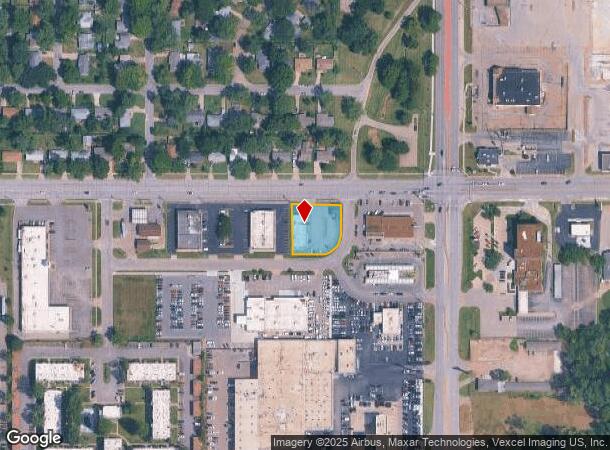
Property Record
901 Sw 37Th St, Topeka, KS 66611
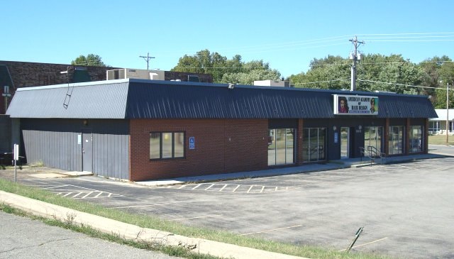
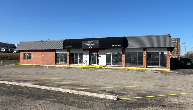
This Property Is For Sale
NEARBY LISTINGS FOR SALE OR LEASE
Property Detail
901 Sw 37Th St
Kansas City
White Lakes Plaza
Topeka, KS
WHITE LAKES PLAZA , BLOCK B , LOT 1 , WHITE LAKES PLAZA SUB BLK B LOT 1 W 37TH TERRACE SECTION 24 TOWNSHIP 12 RANGE 15
146-24-0-10-02-001-000
Shawnee
Storebuilding
Kansas
2024
1
2025
0.50 AC
002800
Topeka
3,840 SF
DEMOGRAPHICS near 901 Sw 37Th St
1 Mile
3 Mile
5 Mile
2024 Total Population
8,334
55,178
123,789
2029 Population
8,373
54,836
122,937
Pop Growth 2024-2029
+ 0.47%
(0.62%)
(0.69%)
Average Age
38
39
40
2024 Total Households
3,422
22,971
51,953
HH Growth 2024-2029
+ 0.61%
(0.67%)
(0.75%)
Median Household Inc
$45,669
$48,103
$50,030
Avg Household Size
2.30
2.30
2.20
2024 Avg HH Vehicles
1.00
2.00
2.00
Median Home Value
$88,535
$106,137
$126,886
Median Year Built
1967
1967
1967
Nearby Places
Map Layers
Map Styles
 Street
 Aerial
- Restaurants
- Banks
- Shops
- Fitness
- Groceries
PUBLIC TRANSPORTATION
COMMUTER RAIL
Topeka Amtrak Station (Southwest Chief - Amtrak)
DRIVE
WALK
Distance
Topeka Amtrak Station (Southwest Chief - Amtrak)
9 min
4.7 mi
Freight Ports
Tulsa Port Of Catoosa
DRIVE
WALK
Distance
Tulsa Port Of Catoosa
271 min
222.6 mi
Nearby Properties
Address
Land Use
TOTAL SIZE
Lot Size
Zoning
Address
Land Use
TOTAL SIZE
Lot Size
Zoning
249,598 SF
150.21 AC
U1
Address
Land Use
TOTAL SIZE
Lot Size
Zoning
117,839 SF
121.95 AC
R1
Address
Land Use
TOTAL SIZE
Lot Size
Zoning
336,669 SF
58.82 AC
PUD,C4
Address
Land Use
TOTAL SIZE
Lot Size
Zoning
77,776 SF
10.64 AC
PUD,M2,R1,
Address
Land Use
TOTAL SIZE
Lot Size
Zoning
80,630 SF
107.16 AC
R1
Address
Land Use
TOTAL SIZE
Lot Size
Zoning
19,120 SF
2.08 AC
R1
Address
Land Use
TOTAL SIZE
Lot Size
Zoning
152,049 SF
25.61 AC
R1
Address
Land Use
TOTAL SIZE
Lot Size
Zoning
103,285 SF
16.99 AC
I1,PUD
Address
Land Use
TOTAL SIZE
Lot Size
Zoning
1,351,980 SF
141.63 AC
I1
Address
Land Use
TOTAL SIZE
Lot Size
Zoning
165,001 SF
24.83 AC
R1
Address
Land Use
TOTAL SIZE
Lot Size
Zoning
52,261 SF
4.59 AC
OI3
Address
Land Use
TOTAL SIZE
Lot Size
Zoning
161,335 SF
37.32 AC
R1
Address
Land Use
TOTAL SIZE
Lot Size
Zoning
100,954 SF
77.35 AC
R1
Address
Land Use
TOTAL SIZE
Lot Size
Zoning
71,575 SF
10.93 AC
C2,C4
Address
Land Use
TOTAL SIZE
Lot Size
Zoning
50,453 SF
14.29 AC
PUD,M2
Address
Land Use
TOTAL SIZE
Lot Size
Zoning
156,628 SF
44.05 AC
I1
Address
Land Use
TOTAL SIZE
Lot Size
Zoning
465,600 SF
52.91 AC
I1
Address
Land Use
TOTAL SIZE
Lot Size
Zoning
40,321 SF
5.69 AC
I1
Address
Land Use
TOTAL SIZE
Lot Size
Zoning
75,691 SF
5.91 AC
M1,M2
Address
Land Use
TOTAL SIZE
Lot Size
Zoning
19.37 AC
Address
Land Use
TOTAL SIZE
Lot Size
Zoning
21,978 SF
2.79 AC
C2,M4
Address
Land Use
TOTAL SIZE
Lot Size
Zoning
38,858 SF
1.01 AC
R1
Address
Land Use
TOTAL SIZE
Lot Size
Zoning
77,793 SF
10.87 AC
C2,M1
Address
Land Use
TOTAL SIZE
Lot Size
Zoning
14,216 SF
0.78 AC
Address
Land Use
TOTAL SIZE
Lot Size
Zoning
33,487 SF
2.65 AC
R1
Address
Land Use
TOTAL SIZE
Lot Size
Zoning
56,485 SF
11.58 AC
I1
Address
Land Use
TOTAL SIZE
Lot Size
Zoning
15,893 SF
0.64 AC
R1
Address
Land Use
TOTAL SIZE
Lot Size
Zoning
34,310 SF
6.01 AC
OI2
Address
Land Use
TOTAL SIZE
Lot Size
Zoning
70,296 SF
6.76 AC
R2
Address
Land Use
TOTAL SIZE
Lot Size
Zoning
46,253 SF
6.23 AC
R1
The World's #1 Commercial Real Estate Marketplace
Connect with us
© 2026 CoStar Group
The information above has been obtained from sources believed reliable. While we do not doubt its accuracy we have not verified it and make no guarantee, warranty or representation about it. It is your responsibility to independently confirm its accuracy and completeness. Any projections, opinions, assumptions, or estimates used are for example only and do not represent the current or future performance of the property. The value of this transaction to you depends on tax and other factors which should be evaluated by your tax, financial, and legal advisors. You and your advisors should conduct a careful, independent investigation of the property to determine to your satisfaction the suitability of the property for your needs.