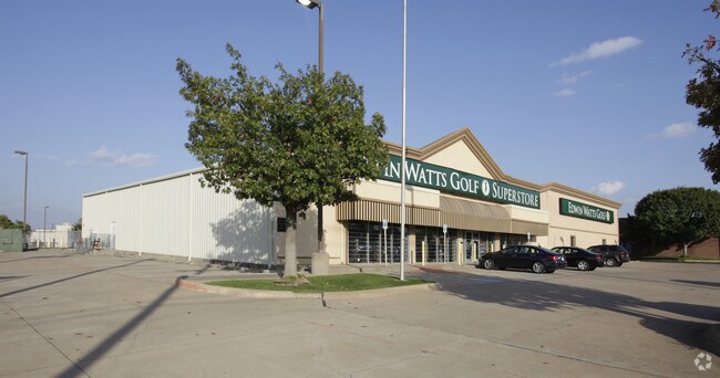
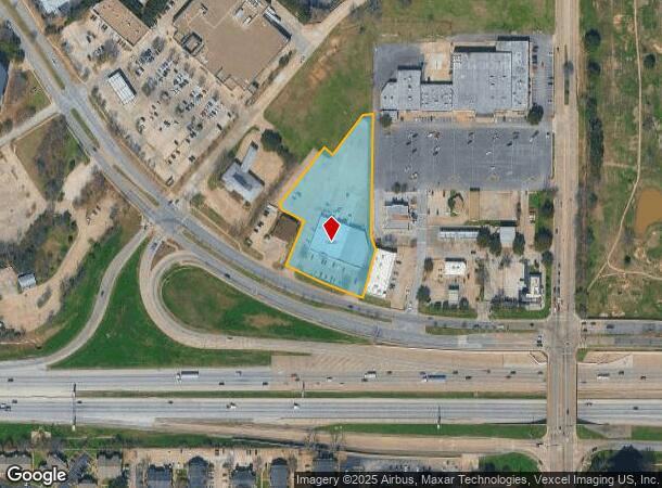
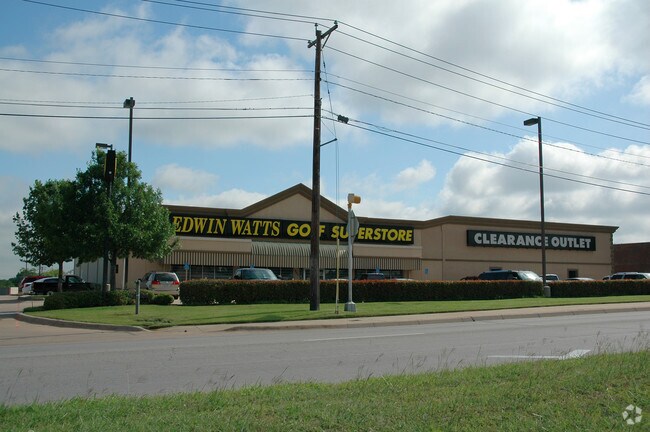
Property Record
901 W Lamar Blvd, Arlington, TX 76012
NEARBY LISTINGS FOR SALE OR LEASE
Property Detail
901 W Lamar Blvd
Dallas-Fort Worth-Arlington, TX
Henderson, J M Addition
06611044
HENDERSON, J M ADDITION LOT 44
Commercialnec
Tarrant
X
Texas
48439C0240L
44
0
2.33 AC
2025
North Arlington
113107
Dallas/Ft Worth
17,351 SF
DEMOGRAPHICS near 901 W Lamar Blvd
1 Mile
3 Mile
5 Mile
2024 Total Population
14,024
105,241
300,437
2029 Population
14,969
111,703
317,066
Pop Growth 2024-2029
+ 6.74%
+ 6.14%
+ 5.53%
Average Age
38
36
36
2024 Total Households
5,795
43,733
116,336
HH Growth 2024-2029
+ 7.11%
+ 6.28%
+ 5.62%
Median Household Inc
$57,948
$49,586
$55,040
Avg Household Size
2.40
2.30
2.50
2024 Avg HH Vehicles
2.00
2.00
2.00
Median Home Value
$276,333
$266,180
$248,950
Median Year Built
1978
1982
1981
Nearby Places
Map Layers
Map Styles
 Street
 Aerial
- Restaurants
- Banks
- Shops
- Fitness
- Groceries
PUBLIC TRANSPORTATION
COMMUTER RAIL
Hurst/Bell (Trinity Railway Express - Dallas Area Rapid Transit (DART))
DRIVE
WALK
Distance
Hurst/Bell (Trinity Railway Express - Dallas Area Rapid Transit (DART))
15 min
5.3 mi
Centre Port/DFW (Trinity Railway Express - Dallas Area Rapid Transit (DART))
DRIVE
WALK
Distance
Centre Port/DFW (Trinity Railway Express - Dallas Area Rapid Transit (DART))
15 min
8.7 mi
AIRPORT
Dallas-Fort Worth International
DRIVE
WALK
Distance
Dallas-Fort Worth International
24 min
14.9 mi
Dallas Love Field
DRIVE
WALK
Distance
Dallas Love Field
34 min
23.2 mi
Nearby Properties
Address
Land Use
TOTAL SIZE
Lot Size
Zoning
Address
Land Use
TOTAL SIZE
Lot Size
Zoning
1,700,000 SF
8.23 AC
Address
Land Use
TOTAL SIZE
Lot Size
Zoning
3,015,800 SF
72.86 AC
Address
Land Use
TOTAL SIZE
Lot Size
Zoning
1,400,000 SF
15.30 AC
Address
Land Use
TOTAL SIZE
Lot Size
Zoning
269,257 SF
21.33 AC
Address
Land Use
TOTAL SIZE
Lot Size
Zoning
378,182 SF
5.02 AC
Address
Land Use
TOTAL SIZE
Lot Size
Zoning
287,560 SF
3.28 AC
Address
Land Use
TOTAL SIZE
Lot Size
Zoning
1,129,022 SF
16.84 AC
Address
Land Use
TOTAL SIZE
Lot Size
Zoning
320,636 SF
12.71 AC
Address
Land Use
TOTAL SIZE
Lot Size
Zoning
595,207 SF
7.20 AC
Address
Land Use
TOTAL SIZE
Lot Size
Zoning
492,970 SF
44.82 AC
Address
Land Use
TOTAL SIZE
Lot Size
Zoning
458,819 SF
15.88 AC
Address
Land Use
TOTAL SIZE
Lot Size
Zoning
462,207 SF
2.82 AC
Address
Land Use
TOTAL SIZE
Lot Size
Zoning
578,395 SF
6.22 AC
Address
Land Use
TOTAL SIZE
Lot Size
Zoning
422,300 SF
2.50 AC
Address
Land Use
TOTAL SIZE
Lot Size
Zoning
347,421 SF
4.47 AC
Address
Land Use
TOTAL SIZE
Lot Size
Zoning
548,806 SF
5.56 AC
Address
Land Use
TOTAL SIZE
Lot Size
Zoning
324,303 SF
23.15 AC
Address
Land Use
TOTAL SIZE
Lot Size
Zoning
139,821 SF
Address
Land Use
TOTAL SIZE
Lot Size
Zoning
492,837 SF
4.99 AC
Address
Land Use
TOTAL SIZE
Lot Size
Zoning
389,946 SF
2.35 AC
Address
Land Use
TOTAL SIZE
Lot Size
Zoning
539,000 SF
3.91 AC
Address
Land Use
TOTAL SIZE
Lot Size
Zoning
300,915 SF
24.90 AC
Address
Land Use
TOTAL SIZE
Lot Size
Zoning
313,349 SF
15.39 AC
Address
Land Use
TOTAL SIZE
Lot Size
Zoning
345,216 SF
21.64 AC
Address
Land Use
TOTAL SIZE
Lot Size
Zoning
137,878 SF
189.88 AC
Address
Land Use
TOTAL SIZE
Lot Size
Zoning
327,309 SF
3.45 AC
Address
Land Use
TOTAL SIZE
Lot Size
Zoning
334,660 SF
17.59 AC
Address
Land Use
TOTAL SIZE
Lot Size
Zoning
720,000 SF
9.80 AC
Address
Land Use
TOTAL SIZE
Lot Size
Zoning
288,378 SF
15.40 AC
Address
Land Use
TOTAL SIZE
Lot Size
Zoning
555,428 SF
14.57 AC
The World's #1 Commercial Real Estate Marketplace
Connect with us
© 2026 CoStar Group
The information above has been obtained from sources believed reliable. While we do not doubt its accuracy we have not verified it and make no guarantee, warranty or representation about it. It is your responsibility to independently confirm its accuracy and completeness. Any projections, opinions, assumptions, or estimates used are for example only and do not represent the current or future performance of the property. The value of this transaction to you depends on tax and other factors which should be evaluated by your tax, financial, and legal advisors. You and your advisors should conduct a careful, independent investigation of the property to determine to your satisfaction the suitability of the property for your needs.