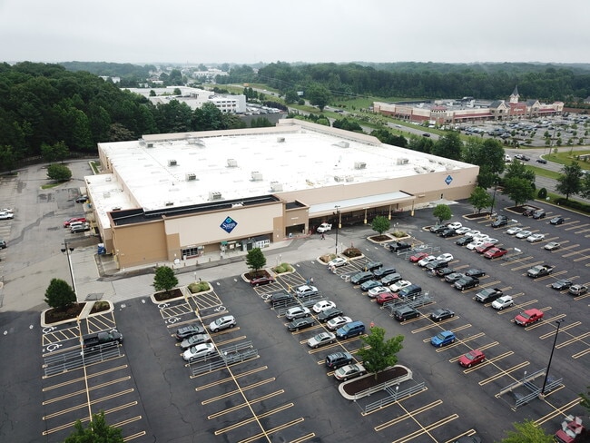
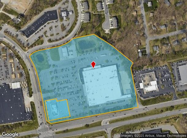
Property Record
901 Walmart Way, Midlothian, VA 23113
NEARBY LISTINGS FOR SALE OR LEASE
Property Detail
901 Walmart Way
736-70-82-35-300-000
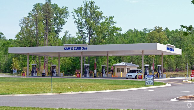
W/L Route 60 (Sams Club)
Commercialnec
W/L ROUTE 60 (SAM'S CLUB)
X
Chesterfield
51145C0170C
Virginia
0
15.10 AC
2025
Midlothian West
100915
Richmond VA
139,484 SF
Richmond, VA
DEMOGRAPHICS near 901 Walmart Way
1 Mile
3 Mile
5 Mile
2024 Total Population
4,604
58,430
124,448
2029 Population
5,062
63,744
135,733
Pop Growth 2024-2029
+ 9.95%
+ 9.09%
+ 9.07%
Average Age
43
42
42
2024 Total Households
1,931
22,762
48,103
HH Growth 2024-2029
+ 10.20%
+ 9.23%
+ 9.08%
Median Household Inc
$74,563
$97,823
$97,801
Avg Household Size
2.40
2.50
2.50
2024 Avg HH Vehicles
2.00
2.00
2.00
Median Home Value
$285,745
$343,157
$341,086
Median Year Built
1982
1987
1987
Nearby Places
Map Layers
Map Styles
 Street
 Aerial
- Restaurants
- Banks
- Shops
- Fitness
- Groceries
PUBLIC TRANSPORTATION
AIRPORT
Richmond International
DRIVE
WALK
Distance
Richmond International
38 min
23.7 mi
Freight Ports
Virginia Port Authority - Richmond
DRIVE
WALK
Distance
Virginia Port Authority - Richmond
27 min
13.8 mi
Nearby Properties
Address
Land Use
TOTAL SIZE
Lot Size
Zoning
Address
Land Use
TOTAL SIZE
Lot Size
Zoning
433,639 SF
72.37 AC
C3 - COMMU
Address
Land Use
TOTAL SIZE
Lot Size
Zoning
5,720 SF
117.22 AC
R9 - SINGL
Address
Land Use
TOTAL SIZE
Lot Size
Zoning
178,546 SF
28.35 AC
A - AGRICU
Address
Land Use
TOTAL SIZE
Lot Size
Zoning
112,053 SF
44.11 AC
R9 - SINGL
Address
Land Use
TOTAL SIZE
Lot Size
Zoning
5,922 SF
17.83 AC
RMF - RES,
Address
Land Use
TOTAL SIZE
Lot Size
Zoning
96,480 SF
22.17 AC
RMF - RES,
Address
Land Use
TOTAL SIZE
Lot Size
Zoning
123,252 SF
48.88 AC
R7 - SINGL
Address
Land Use
TOTAL SIZE
Lot Size
Zoning
108,805 SF
21.09 AC
RMF - RES,
Address
Land Use
TOTAL SIZE
Lot Size
Zoning
236,243 SF
90.17 AC
R9 - SINGL
Address
Land Use
TOTAL SIZE
Lot Size
Zoning
71,849 SF
25 AC
RMF - RES,
Address
Land Use
TOTAL SIZE
Lot Size
Zoning
100 SF
8.12 AC
C3 - COMMU
Address
Land Use
TOTAL SIZE
Lot Size
Zoning
241,433 SF
68.39 AC
R15 - SING
Address
Land Use
TOTAL SIZE
Lot Size
Zoning
72,417 SF
11.76 AC
R7 - SINGL
Address
Land Use
TOTAL SIZE
Lot Size
Zoning
100 SF
27.09 AC
R7 - SINGL
Address
Land Use
TOTAL SIZE
Lot Size
Zoning
100 SF
15 AC
C4 - REGIO
Address
Land Use
TOTAL SIZE
Lot Size
Zoning
29.24 AC
O2 - CORP
Address
Land Use
TOTAL SIZE
Lot Size
Zoning
100 SF
9.79 AC
C4 - REGIO
Address
Land Use
TOTAL SIZE
Lot Size
Zoning
106,256 SF
18.66 AC
R7 - SINGL
Address
Land Use
TOTAL SIZE
Lot Size
Zoning
174,840 SF
21.13 AC
R7 - SINGL
Address
Land Use
TOTAL SIZE
Lot Size
Zoning
768 SF
49.45 AC
R40 - SING
Address
Land Use
TOTAL SIZE
Lot Size
Zoning
95,944 SF
14.76 AC
A - AGRICU
Address
Land Use
TOTAL SIZE
Lot Size
Zoning
118,712 SF
16.25 AC
C3 - COMMU
Address
Land Use
TOTAL SIZE
Lot Size
Zoning
132,784 SF
6.33 AC
O2 - CORP
Address
Land Use
TOTAL SIZE
Lot Size
Zoning
36,237 SF
16.67 AC
C3 - COMMU
Address
Land Use
TOTAL SIZE
Lot Size
Zoning
206,183 SF
25.21 AC
C3 - COMMU
Address
Land Use
TOTAL SIZE
Lot Size
Zoning
4.45 AC
RMF - RES,
Address
Land Use
TOTAL SIZE
Lot Size
Zoning
97,740 SF
20.97 AC
R7 - SINGL
Address
Land Use
TOTAL SIZE
Lot Size
Zoning
12,309 SF
14.20 AC
C3 - COMMU
Address
Land Use
TOTAL SIZE
Lot Size
Zoning
49,510 SF
8.86 AC
C3 - COMMU
Address
Land Use
TOTAL SIZE
Lot Size
Zoning
51,683 SF
3.31 AC
I1 - LT IN
The World's #1 Commercial Real Estate Marketplace
Connect with us
© 2025 CoStar Group
The information above has been obtained from sources believed reliable. While we do not doubt its accuracy we have not verified it and make no guarantee, warranty or representation about it. It is your responsibility to independently confirm its accuracy and completeness. Any projections, opinions, assumptions, or estimates used are for example only and do not represent the current or future performance of the property. The value of this transaction to you depends on tax and other factors which should be evaluated by your tax, financial, and legal advisors. You and your advisors should conduct a careful, independent investigation of the property to determine to your satisfaction the suitability of the property for your needs.