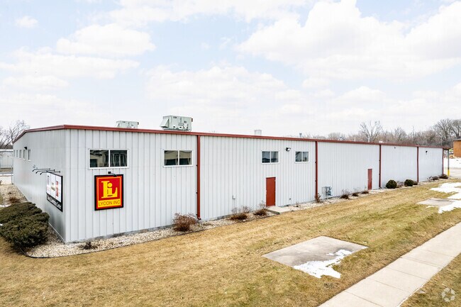
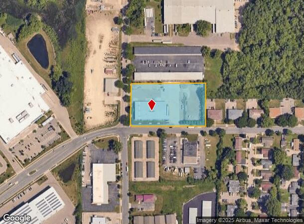
Property Record
901 Walsh Rd, Madison, WI 53714
NEARBY LISTINGS FOR SALE OR LEASE
Property Detail
901 Walsh Rd
Madison, WI
Certified Survey Map No 8190 Recorded In
0810-334-0108-5
CERTIFIED SURVEY MAP NO 8190 RECORDED IN DANE COUNTY REGISTER OF DEEDS IN VOL 44 PAGE 84 OF CERTIFIED SURVEYS AS DOCUMENT 2757267, LOT 2.
Commercialnec
Dane
X
Wisconsin
55025C0431H
2
2024
2.42 AC
2024
Northeast Madison
002603
Milwaukee/Madison
12,100 SF
DEMOGRAPHICS near 901 Walsh Rd
1 mile
3 mile
5 mile
2024 Total Population
8,518
71,444
141,213
2029 Population
8,727
74,333
146,307
Pop Growth 2024-2029
+ 2.45%
+ 4.04%
+ 3.61%
Average Age
38
40
39
2024 Total Households
3,714
33,158
66,485
HH Growth 2024-2029
+ 2.53%
+ 4.13%
+ 3.70%
Median Household Inc
$54,948
$69,137
$67,176
Avg Household Size
2.20
2.10
2.00
2024 Avg HH Vehicles
1.00
2.00
2.00
Median Home Value
$246,175
$263,068
$280,926
Median Year Built
1976
1974
1976
Nearby Places
Map Layers
Map Styles
 Street
 Aerial
Transit
 Traffic
 Biking
Places
Listings with unknown addresses are not visible on the map
- Restaurants
- Banks
- Shops
- Fitness
- Groceries
PUBLIC TRANSPORTATION
AIRPORT
Dane County Regional/Truax Field
Drive
Walk
Distance
Dane County Regional/Truax Field
9 min
4.0 mi
SALE & LEASE HISTORY
LISTING DATE
SALE/LEASE

May 16, 2019
For Sale
Nearby Properties
Address
Land Use
TOTAL SIZE
Lot Size
Zoning
Address
Land Use
TOTAL SIZE
Lot Size
Zoning
27.70 AC
SEC
Address
Land Use
TOTAL SIZE
Lot Size
Zoning
509,946 SF
40.17 AC
IL
Address
Land Use
TOTAL SIZE
Lot Size
Zoning
461,454 SF
3.37 AC
CC-T
Address
Land Use
TOTAL SIZE
Lot Size
Zoning
81,771 SF
7.76 AC
CC-T
Address
Land Use
TOTAL SIZE
Lot Size
Zoning
251,632 SF
3.88 AC
TE
Address
Land Use
TOTAL SIZE
Lot Size
Zoning
289,884 SF
19.36 AC
SR-V2
Address
Land Use
TOTAL SIZE
Lot Size
Zoning
97,580 SF
6.86 AC
TR-U1
Address
Land Use
TOTAL SIZE
Lot Size
Zoning
357,427 SF
12.77 AC
PD
Address
Land Use
TOTAL SIZE
Lot Size
Zoning
13,440 SF
10.98 AC
IL
Address
Land Use
TOTAL SIZE
Lot Size
Zoning
216,017 SF
3.35 AC
TE
Address
Land Use
TOTAL SIZE
Lot Size
Zoning
372,177 SF
19.47 AC
SR-V2
Address
Land Use
TOTAL SIZE
Lot Size
Zoning
294,106 SF
29.06 AC
CC
Address
Land Use
TOTAL SIZE
Lot Size
Zoning
12,450 SF
9.40 AC
SE
Address
Land Use
TOTAL SIZE
Lot Size
Zoning
225,108 SF
2 AC
PD
Address
Land Use
TOTAL SIZE
Lot Size
Zoning
104,000 SF
11.21 AC
CC-T
Address
Land Use
TOTAL SIZE
Lot Size
Zoning
316,954 SF
24.96 AC
SEC
Address
Land Use
TOTAL SIZE
Lot Size
Zoning
101,348 SF
6.37 AC
SEC
Address
Land Use
TOTAL SIZE
Lot Size
Zoning
6.76 AC
SEC
Address
Land Use
TOTAL SIZE
Lot Size
Zoning
Address
Land Use
TOTAL SIZE
Lot Size
Zoning
92,130 SF
3.36 AC
PD
Address
Land Use
TOTAL SIZE
Lot Size
Zoning
167,519 SF
4.51 AC
PD
Address
Land Use
TOTAL SIZE
Lot Size
Zoning
105,743 SF
9.50 AC
IG
Address
Land Use
TOTAL SIZE
Lot Size
Zoning
37,133 SF
4.71 AC
CC-T
Address
Land Use
TOTAL SIZE
Lot Size
Zoning
191,145 SF
12.24 AC
SR-V2
Address
Land Use
TOTAL SIZE
Lot Size
Zoning
149,650 SF
21.35 AC
CC
Address
Land Use
TOTAL SIZE
Lot Size
Zoning
154,403 SF
1.21 AC
PD
Address
Land Use
TOTAL SIZE
Lot Size
Zoning
176,496 SF
3.51 AC
PD
Address
Land Use
TOTAL SIZE
Lot Size
Zoning
68,016 SF
6.45 AC
PD
Address
Land Use
TOTAL SIZE
Lot Size
Zoning
171,950 SF
11.28 AC
PD
Address
Land Use
TOTAL SIZE
Lot Size
Zoning
134,008 SF
5.63 AC
SR-V2
The World's #1 Commercial Real Estate Marketplace
Connect with us
© 2026 CoStar Group
The information above has been obtained from sources believed reliable. While we do not doubt its accuracy we have not verified it and make no guarantee, warranty or representation about it. It is your responsibility to independently confirm its accuracy and completeness. Any projections, opinions, assumptions, or estimates used are for example only and do not represent the current or future performance of the property. The value of this transaction to you depends on tax and other factors which should be evaluated by your tax, financial, and legal advisors. You and your advisors should conduct a careful, independent investigation of the property to determine to your satisfaction the suitability of the property for your needs.