Property Record
9010 Brook Rd, Glen Allen, VA 23060


NEARBY LISTINGS FOR SALE OR LEASE
Property Detail
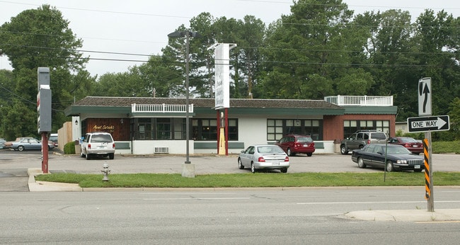
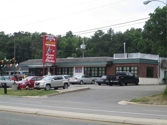
9010 Brook Rd
783-760-8674
00530A0000 0014; WS U S RT # 1 AC .866 PAR A 104 A1 83
Restaurantbuilding
Henrico
X
Virginia
51085C0315C
0.87 AC
2025
Staples Mill/Parham
2025
Richmond VA
200908
Richmond, VA
6,988 SF
DEMOGRAPHICS near 9010 Brook Rd
1 Mile
3 Mile
5 Mile
2024 Total Population
6,493
51,126
151,861
2029 Population
6,509
51,589
154,881
Pop Growth 2024-2029
+ 0.25%
+ 0.91%
+ 1.99%
Average Age
39
41
41
2024 Total Households
2,700
21,046
62,747
HH Growth 2024-2029
+ 0.07%
+ 0.80%
+ 2.01%
Median Household Inc
$66,256
$73,540
$75,982
Avg Household Size
2.40
2.40
2.30
2024 Avg HH Vehicles
2.00
2.00
2.00
Median Home Value
$247,971
$264,462
$290,816
Median Year Built
1982
1981
1980
Nearby Places
Map Layers
Map Styles
 Street
 Aerial
- Restaurants
- Banks
- Shops
- Fitness
- Groceries
PUBLIC TRANSPORTATION
COMMUTER RAIL
DRIVE
WALK
Distance
10 min
4.4 mi
DRIVE
WALK
Distance
16 min
8.5 mi
AIRPORT
Richmond International
DRIVE
WALK
Distance
Richmond International
27 min
18.5 mi
Freight Ports
Virginia Port Authority - Richmond
DRIVE
WALK
Distance
Virginia Port Authority - Richmond
25 min
15.6 mi
Nearby Properties
Address
Land Use
TOTAL SIZE
Lot Size
Zoning
Address
Land Use
TOTAL SIZE
Lot Size
Zoning
136.01 AC
A-1
Address
Land Use
TOTAL SIZE
Lot Size
Zoning
43,929 SF
46.83 AC
O-S
Address
Land Use
TOTAL SIZE
Lot Size
Zoning
104,972 SF
108.49 AC
MIXE
Address
Land Use
TOTAL SIZE
Lot Size
Zoning
347,648 SF
24.75 AC
R-5
Address
Land Use
TOTAL SIZE
Lot Size
Zoning
186,034 SF
13.86 AC
B-3C
Address
Land Use
TOTAL SIZE
Lot Size
Zoning
135,874 SF
31.99 AC
MIXE
Address
Land Use
TOTAL SIZE
Lot Size
Zoning
180,070 SF
17.13 AC
R-5
Address
Land Use
TOTAL SIZE
Lot Size
Zoning
102,942 SF
71.86 AC
MIXE
Address
Land Use
TOTAL SIZE
Lot Size
Zoning
104,023 SF
98.16 AC
MIXE
Address
Land Use
TOTAL SIZE
Lot Size
Zoning
24,165 SF
72.13 AC
C-1
Address
Land Use
TOTAL SIZE
Lot Size
Zoning
226,400 SF
14.70 AC
R-5
Address
Land Use
TOTAL SIZE
Lot Size
Zoning
10,818 SF
161.99 AC
MIXE
Address
Land Use
TOTAL SIZE
Lot Size
Zoning
62,919 SF
17.87 AC
R-3
Address
Land Use
TOTAL SIZE
Lot Size
Zoning
251,400 SF
16.18 AC
R-6C
Address
Land Use
TOTAL SIZE
Lot Size
Zoning
160,000 SF
25 AC
M-1
Address
Land Use
TOTAL SIZE
Lot Size
Zoning
216,900 SF
13.41 AC
R-6
Address
Land Use
TOTAL SIZE
Lot Size
Zoning
159,432 SF
14 AC
R-5
Address
Land Use
TOTAL SIZE
Lot Size
Zoning
138,140 SF
7.66 AC
R-6
Address
Land Use
TOTAL SIZE
Lot Size
Zoning
114,958 SF
20 AC
R-4
Address
Land Use
TOTAL SIZE
Lot Size
Zoning
7,295 SF
72.17 AC
Address
Land Use
TOTAL SIZE
Lot Size
Zoning
112,893 SF
58.52 AC
MIXE
Address
Land Use
TOTAL SIZE
Lot Size
Zoning
11.06 AC
R-6
Address
Land Use
TOTAL SIZE
Lot Size
Zoning
182,096 SF
16.70 AC
R-5
Address
Land Use
TOTAL SIZE
Lot Size
Zoning
204,358 SF
25.99 AC
B-3
Address
Land Use
TOTAL SIZE
Lot Size
Zoning
33,931 SF
30.81 AC
R-3
Address
Land Use
TOTAL SIZE
Lot Size
Zoning
230,464 SF
22.76 AC
R-5
Address
Land Use
TOTAL SIZE
Lot Size
Zoning
42.30 AC
MIXE
Address
Land Use
TOTAL SIZE
Lot Size
Zoning
304,119 SF
93.21 AC
UMUC
Address
Land Use
TOTAL SIZE
Lot Size
Zoning
113,870 SF
8.19 AC
R-5
Address
Land Use
TOTAL SIZE
Lot Size
Zoning
76,749 SF
22.25 AC
A-1
The World's #1 Commercial Real Estate Marketplace
Connect with us
© 2026 CoStar Group
The information above has been obtained from sources believed reliable. While we do not doubt its accuracy we have not verified it and make no guarantee, warranty or representation about it. It is your responsibility to independently confirm its accuracy and completeness. Any projections, opinions, assumptions, or estimates used are for example only and do not represent the current or future performance of the property. The value of this transaction to you depends on tax and other factors which should be evaluated by your tax, financial, and legal advisors. You and your advisors should conduct a careful, independent investigation of the property to determine to your satisfaction the suitability of the property for your needs.