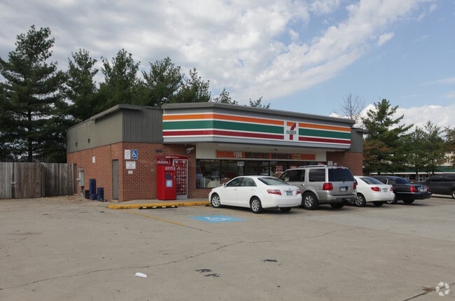
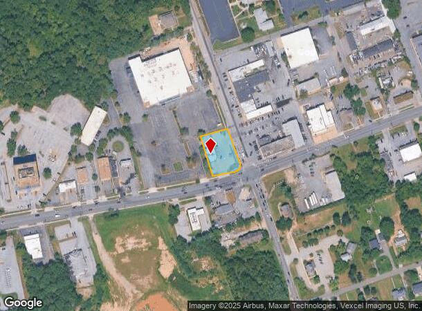
Property Record
9019 Old Branch Ave, Clinton, MD 20735

NEARBY LISTINGS FOR SALE OR LEASE
Property Detail
9019 Old Branch Ave
09-0888610
PARCEL A
Storebuilding
Prince George's
X
Maryland
24033C0245E
0.54 AC
2024
Branch Avenue Corridor
2025
Washington, DC
801217
Washington-Arlington-Alexandria, DC-VA-MD-WV
2,624 SF
DEMOGRAPHICS near 9019 Old Branch Ave
1 Mile
3 Mile
5 Mile
2024 Total Population
7,821
47,226
121,126
2029 Population
7,603
45,899
117,878
Pop Growth 2024-2029
(2.79%)
(2.81%)
(2.68%)
Average Age
45
43
42
2024 Total Households
2,643
16,173
43,893
HH Growth 2024-2029
(2.95%)
(2.94%)
(2.75%)
Median Household Inc
$108,681
$112,343
$106,715
Avg Household Size
2.80
2.80
2.70
2024 Avg HH Vehicles
2.00
2.00
2.00
Median Home Value
$363,862
$375,674
$380,087
Median Year Built
1981
1982
1981
Nearby Places
Map Layers
Map Styles
 Street
 Aerial
- Restaurants
- Banks
- Shops
- Fitness
- Groceries
PUBLIC TRANSPORTATION
AIRPORT
Ronald Reagan Washington Ntl
DRIVE
WALK
Distance
Ronald Reagan Washington Ntl
31 min
17.5 mi
Baltimore/Washington International Thurgood Marshall
DRIVE
WALK
Distance
Baltimore/Washington International Thurgood Marshall
56 min
38.8 mi
Washington Dulles International
DRIVE
WALK
Distance
Washington Dulles International
67 min
44.6 mi
Freight Ports
Port of Baltimore
DRIVE
WALK
Distance
Port of Baltimore
65 min
45.1 mi
Nearby Properties
Address
Land Use
TOTAL SIZE
Lot Size
Zoning
Address
Land Use
TOTAL SIZE
Lot Size
Zoning
353,064 SF
53.19 AC
CGO
Address
Land Use
TOTAL SIZE
Lot Size
Zoning
7,000 SF
354.62 AC
ROS
Address
Land Use
TOTAL SIZE
Lot Size
Zoning
341,372 SF
14.74 AC
RR
Address
Land Use
TOTAL SIZE
Lot Size
Zoning
73.26 AC
IE
Address
Land Use
TOTAL SIZE
Lot Size
Zoning
223,219 SF
22 AC
CGO
Address
Land Use
TOTAL SIZE
Lot Size
Zoning
74.38 AC
IE
Address
Land Use
TOTAL SIZE
Lot Size
Zoning
300,005 SF
9.94 AC
RR
Address
Land Use
TOTAL SIZE
Lot Size
Zoning
138.27 AC
IE
Address
Land Use
TOTAL SIZE
Lot Size
Zoning
434,910 SF
0.46 AC
RR
Address
Land Use
TOTAL SIZE
Lot Size
Zoning
160,870 SF
3.75 AC
RMF48
Address
Land Use
TOTAL SIZE
Lot Size
Zoning
174,894 SF
7.54 AC
CGO
Address
Land Use
TOTAL SIZE
Lot Size
Zoning
55,724 SF
10.09 AC
IE
Address
Land Use
TOTAL SIZE
Lot Size
Zoning
67.32 AC
IE
Address
Land Use
TOTAL SIZE
Lot Size
Zoning
169.75 AC
IE
Address
Land Use
TOTAL SIZE
Lot Size
Zoning
78,658 SF
9.13 AC
RR
Address
Land Use
TOTAL SIZE
Lot Size
Zoning
101,979 SF
2.11 AC
CGO
Address
Land Use
TOTAL SIZE
Lot Size
Zoning
161,410 SF
30 AC
RSF95
Address
Land Use
TOTAL SIZE
Lot Size
Zoning
4.56 AC
CGO
Address
Land Use
TOTAL SIZE
Lot Size
Zoning
0.72 AC
IE
Address
Land Use
TOTAL SIZE
Lot Size
Zoning
68,304 SF
8.09 AC
RSF95
Address
Land Use
TOTAL SIZE
Lot Size
Zoning
100,660 SF
9.12 AC
CGO
Address
Land Use
TOTAL SIZE
Lot Size
Zoning
180.47 AC
IE
Address
Land Use
TOTAL SIZE
Lot Size
Zoning
301,033 SF
35.46 AC
RR
Address
Land Use
TOTAL SIZE
Lot Size
Zoning
122.43 AC
IE
Address
Land Use
TOTAL SIZE
Lot Size
Zoning
120,986 SF
16.42 AC
RR
Address
Land Use
TOTAL SIZE
Lot Size
Zoning
123,516 SF
20 AC
RSF95
Address
Land Use
TOTAL SIZE
Lot Size
Zoning
134,247 SF
9.24 AC
CGO
Address
Land Use
TOTAL SIZE
Lot Size
Zoning
122.63 AC
IE
Address
Land Use
TOTAL SIZE
Lot Size
Zoning
120,686 SF
16.40 AC
RSF95
Address
Land Use
TOTAL SIZE
Lot Size
Zoning
41.87 AC
IE
The World's #1 Commercial Real Estate Marketplace
Connect with us
© 2025 CoStar Group
The information above has been obtained from sources believed reliable. While we do not doubt its accuracy we have not verified it and make no guarantee, warranty or representation about it. It is your responsibility to independently confirm its accuracy and completeness. Any projections, opinions, assumptions, or estimates used are for example only and do not represent the current or future performance of the property. The value of this transaction to you depends on tax and other factors which should be evaluated by your tax, financial, and legal advisors. You and your advisors should conduct a careful, independent investigation of the property to determine to your satisfaction the suitability of the property for your needs.