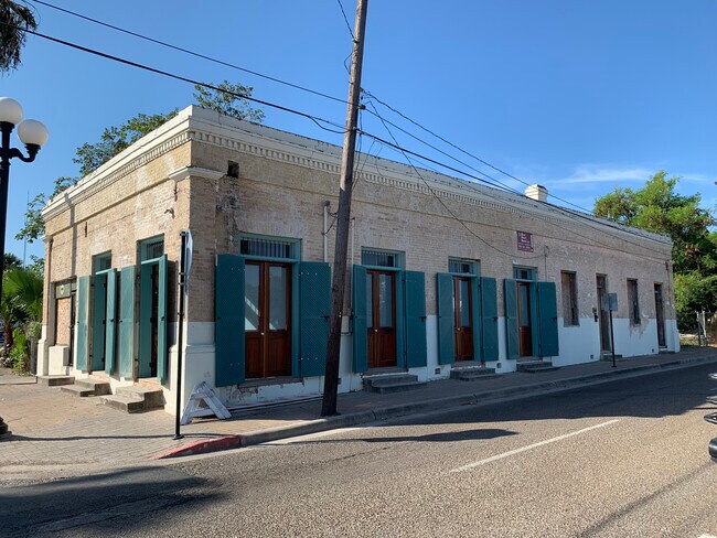
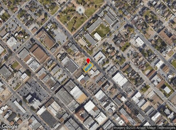
Property Record
902 E Adams St, Brownsville, TX 78520

NEARBY LISTINGS FOR SALE OR LEASE
Property Detail
902 E Adams St
Brownsville-Harlingen, TX
Brownsville Original Townsite (Vol 5 Pg
010000-0850-006000
LOT 6 BLK 85 BROWNSVILLE ORIGINAL TOWNSITE (VOL 5 PG 13 MRCC)
Commercialnec
Cameron
X
Texas
48061C0590F
6
2024
0.14 AC
2025
Downtown Brownsville
014001
Brownsville/Harlingen
3,201 SF
DEMOGRAPHICS near 902 E Adams St
1 Mile
3 Mile
5 Mile
2024 Total Population
12,635
64,795
155,774
2029 Population
12,869
66,333
159,379
Pop Growth 2024-2029
+ 1.85%
+ 2.37%
+ 2.31%
Average Age
37
37
36
2024 Total Households
4,389
21,728
48,849
HH Growth 2024-2029
+ 1.71%
+ 2.31%
+ 2.34%
Median Household Inc
$25,606
$33,965
$40,275
Avg Household Size
2.70
2.90
3.10
2024 Avg HH Vehicles
1.00
2.00
2.00
Median Home Value
$61,955
$74,093
$89,814
Median Year Built
1973
1977
1989
Nearby Places
Map Layers
Map Styles
 Street
 Aerial
- Restaurants
- Banks
- Shops
- Fitness
- Groceries
PUBLIC TRANSPORTATION
AIRPORT
Brownsville/South Padre Island International
DRIVE
WALK
Distance
Brownsville/South Padre Island International
10 min
5.3 mi
Valley International
DRIVE
WALK
Distance
Valley International
45 min
28.8 mi
Freight Ports
Port of Brownsville
DRIVE
WALK
Distance
Port of Brownsville
12 min
6.9 mi
SALE & LEASE HISTORY
LISTING DATE
SALE/LEASE

Sep 19, 2023
For Sale
Sep 19, 2023
For Lease
Nearby Properties
Address
Land Use
TOTAL SIZE
Lot Size
Zoning
Address
Land Use
TOTAL SIZE
Lot Size
Zoning
591,279 SF
49.02 AC
Address
Land Use
TOTAL SIZE
Lot Size
Zoning
319,798 SF
46.28 AC
Address
Land Use
TOTAL SIZE
Lot Size
Zoning
363,515 SF
34.39 AC
Address
Land Use
TOTAL SIZE
Lot Size
Zoning
302,902 SF
6.61 AC
C
Address
Land Use
TOTAL SIZE
Lot Size
Zoning
277,742 SF
31.28 AC
Address
Land Use
TOTAL SIZE
Lot Size
Zoning
72,436 SF
22.08 AC
Address
Land Use
TOTAL SIZE
Lot Size
Zoning
167,653 SF
5.10 AC
Address
Land Use
TOTAL SIZE
Lot Size
Zoning
132,197 SF
10.70 AC
Address
Land Use
TOTAL SIZE
Lot Size
Zoning
213,521 SF
38.75 AC
Address
Land Use
TOTAL SIZE
Lot Size
Zoning
98,006 SF
20.30 AC
Address
Land Use
TOTAL SIZE
Lot Size
Zoning
133,476 SF
8.14 AC
Address
Land Use
TOTAL SIZE
Lot Size
Zoning
107,815 SF
10 AC
Address
Land Use
TOTAL SIZE
Lot Size
Zoning
142,385 SF
0.50 AC
Address
Land Use
TOTAL SIZE
Lot Size
Zoning
176,990 SF
18.31 AC
C
Address
Land Use
TOTAL SIZE
Lot Size
Zoning
110,431 SF
15 AC
Address
Land Use
TOTAL SIZE
Lot Size
Zoning
80,480 SF
10.68 AC
Address
Land Use
TOTAL SIZE
Lot Size
Zoning
101,569 SF
1.95 AC
Address
Land Use
TOTAL SIZE
Lot Size
Zoning
241,619 SF
14.68 AC
Address
Land Use
TOTAL SIZE
Lot Size
Zoning
76,588 SF
2 AC
Address
Land Use
TOTAL SIZE
Lot Size
Zoning
57,845 SF
10.52 AC
Address
Land Use
TOTAL SIZE
Lot Size
Zoning
48,468 SF
2.65 AC
C
Address
Land Use
TOTAL SIZE
Lot Size
Zoning
96,314 SF
6.77 AC
C
Address
Land Use
TOTAL SIZE
Lot Size
Zoning
69,922 SF
4.13 AC
Address
Land Use
TOTAL SIZE
Lot Size
Zoning
102,316 SF
10.93 AC
Address
Land Use
TOTAL SIZE
Lot Size
Zoning
56,918 SF
2.95 AC
Address
Land Use
TOTAL SIZE
Lot Size
Zoning
85,803 SF
2.75 AC
Address
Land Use
TOTAL SIZE
Lot Size
Zoning
189,213 SF
10.40 AC
C
Address
Land Use
TOTAL SIZE
Lot Size
Zoning
35,447 SF
3.16 AC
Address
Land Use
TOTAL SIZE
Lot Size
Zoning
141,109 SF
7.34 AC
Address
Land Use
TOTAL SIZE
Lot Size
Zoning
53,035 SF
2 AC
The World's #1 Commercial Real Estate Marketplace
Connect with us
© 2025 CoStar Group
The information above has been obtained from sources believed reliable. While we do not doubt its accuracy we have not verified it and make no guarantee, warranty or representation about it. It is your responsibility to independently confirm its accuracy and completeness. Any projections, opinions, assumptions, or estimates used are for example only and do not represent the current or future performance of the property. The value of this transaction to you depends on tax and other factors which should be evaluated by your tax, financial, and legal advisors. You and your advisors should conduct a careful, independent investigation of the property to determine to your satisfaction the suitability of the property for your needs.