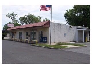
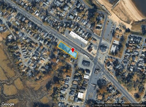
Property Record
902 Highway 35, Laurence Hbr, NJ 08879

NEARBY LISTINGS FOR SALE OR LEASE
Property Detail
902 Highway 35
New York-Jersey City-White Plains, NY-NJ
Laurence Harbor
15-01010-0000-00867-11
0.489AC
Uspostalservice
Middlesex
X
New Jersey
34023C0178F
867.1
2024
0.49 AC
2025
South Edison
007402
Northern New Jersey
8,000 SF
DEMOGRAPHICS near 902 Highway 35
1 Mile
3 Mile
5 Mile
2024 Total Population
4,898
59,263
191,516
2029 Population
4,911
59,080
188,742
Pop Growth 2024-2029
+ 0.27%
(0.31%)
(1.45%)
Average Age
42
41
40
2024 Total Households
1,905
23,516
69,722
HH Growth 2024-2029
+ 0.16%
(0.37%)
(1.41%)
Median Household Inc
$85,925
$88,135
$91,195
Avg Household Size
2.50
2.50
2.70
2024 Avg HH Vehicles
2.00
2.00
2.00
Median Home Value
$269,354
$349,077
$395,652
Median Year Built
1956
1968
1968
Nearby Places
Map Layers
Map Styles
 Street
 Aerial
- Restaurants
- Banks
- Shops
- Fitness
- Groceries
PUBLIC TRANSPORTATION
COMMUTER RAIL
Aberdeen Matawan (North Jersey Coast Line - NJ Transit Commuter Rail (NJ Transit))
DRIVE
WALK
Distance
Aberdeen Matawan (North Jersey Coast Line - NJ Transit Commuter Rail (NJ Transit))
5 min
3.7 mi
South Amboy (North Jersey Coast Line - NJ Transit Commuter Rail (NJ Transit))
DRIVE
WALK
Distance
South Amboy (North Jersey Coast Line - NJ Transit Commuter Rail (NJ Transit))
8 min
3.9 mi
AIRPORT
Newark Liberty International
DRIVE
WALK
Distance
Newark Liberty International
35 min
24.8 mi
LaGuardia
DRIVE
WALK
Distance
LaGuardia
64 min
42.1 mi
John F Kennedy International
DRIVE
WALK
Distance
John F Kennedy International
66 min
45.3 mi
Freight Ports
New York Container Terminal
DRIVE
WALK
Distance
New York Container Terminal
28 min
19.9 mi
Nearby Properties
Address
Land Use
TOTAL SIZE
Lot Size
Zoning
Address
Land Use
TOTAL SIZE
Lot Size
Zoning
0.28 AC
CBD
Address
Land Use
TOTAL SIZE
Lot Size
Zoning
Address
Land Use
TOTAL SIZE
Lot Size
Zoning
Address
Land Use
TOTAL SIZE
Lot Size
Zoning
2.14 AC
C-4
Address
Land Use
TOTAL SIZE
Lot Size
Zoning
Address
Land Use
TOTAL SIZE
Lot Size
Zoning
70,624 SF
1.56 AC
WD
Address
Land Use
TOTAL SIZE
Lot Size
Zoning
2.70 AC
LI
Address
Land Use
TOTAL SIZE
Lot Size
Zoning
10.58 AC
APTH
Address
Land Use
TOTAL SIZE
Lot Size
Zoning
4.23 AC
LI
Address
Land Use
TOTAL SIZE
Lot Size
Zoning
7,904 SF
60 AC
AF
Address
Land Use
TOTAL SIZE
Lot Size
Zoning
Address
Land Use
TOTAL SIZE
Lot Size
Zoning
9.12 AC
APTH
Address
Land Use
TOTAL SIZE
Lot Size
Zoning
420 SF
87.76 AC
OL2
Address
Land Use
TOTAL SIZE
Lot Size
Zoning
8.99 AC
MF0
Address
Land Use
TOTAL SIZE
Lot Size
Zoning
31.22 AC
G1
Address
Land Use
TOTAL SIZE
Lot Size
Zoning
1.58 AC
Address
Land Use
TOTAL SIZE
Lot Size
Zoning
162,250 SF
2.80 AC
RC
Address
Land Use
TOTAL SIZE
Lot Size
Zoning
3.29 AC
M1
Address
Land Use
TOTAL SIZE
Lot Size
Zoning
6.80 AC
RM
Address
Land Use
TOTAL SIZE
Lot Size
Zoning
136,121 SF
12.84 AC
RB
Address
Land Use
TOTAL SIZE
Lot Size
Zoning
Address
Land Use
TOTAL SIZE
Lot Size
Zoning
7,905 SF
26.55 AC
CC
Address
Land Use
TOTAL SIZE
Lot Size
Zoning
Address
Land Use
TOTAL SIZE
Lot Size
Zoning
7,904 SF
30 AC
AF
Address
Land Use
TOTAL SIZE
Lot Size
Zoning
7,905 SF
22.82 AC
CC
Address
Land Use
TOTAL SIZE
Lot Size
Zoning
136,925 SF
6.66 AC
R100
Address
Land Use
TOTAL SIZE
Lot Size
Zoning
6.40 AC
RM
Address
Land Use
TOTAL SIZE
Lot Size
Zoning
7,904 SF
69.62 AC
AF
Address
Land Use
TOTAL SIZE
Lot Size
Zoning
16.58 AC
LI
Address
Land Use
TOTAL SIZE
Lot Size
Zoning
8,000 SF
312.58 AC
ER
The World's #1 Commercial Real Estate Marketplace
Connect with us
© 2025 CoStar Group
The information above has been obtained from sources believed reliable. While we do not doubt its accuracy we have not verified it and make no guarantee, warranty or representation about it. It is your responsibility to independently confirm its accuracy and completeness. Any projections, opinions, assumptions, or estimates used are for example only and do not represent the current or future performance of the property. The value of this transaction to you depends on tax and other factors which should be evaluated by your tax, financial, and legal advisors. You and your advisors should conduct a careful, independent investigation of the property to determine to your satisfaction the suitability of the property for your needs.