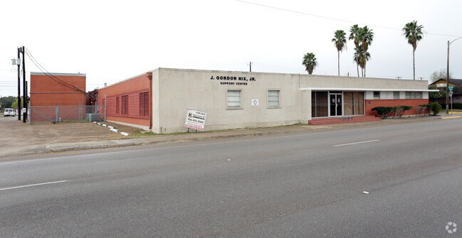
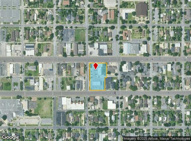
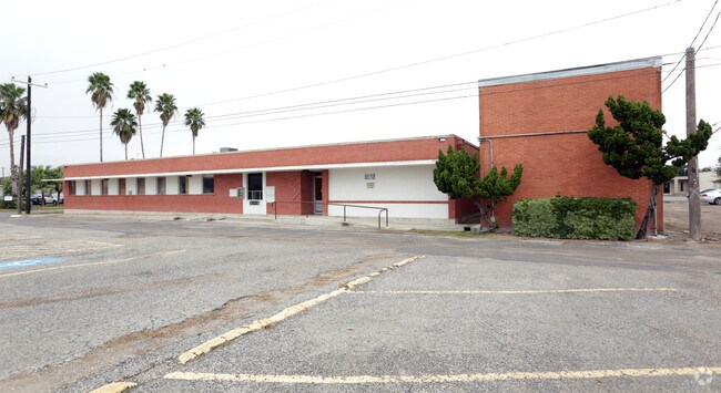
Property Record
902 Tyler, Harlingen, TX 78550
NEARBY LISTINGS FOR SALE OR LEASE
Property Detail
902 Tyler
Brownsville/Harlingen
Circle K (Harlingen) Subdivision
Brownsville-Harlingen, TX
LOT 1 BLK 1 CIRCLE K (HARLINGEN) SUBDIVISION (2022 PLAT C1-4168 CCMR FILED 4/28/2021)
164971-0010-001000
Cameron
Commercialnec
Texas
2024
1
2025
1.24 AC
3,960 SF
Greater Harlingen
DEMOGRAPHICS near 902 Tyler
1 Mile
3 Mile
5 Mile
2024 Total Population
12,916
63,934
97,148
2029 Population
13,266
65,443
99,461
Pop Growth 2024-2029
+ 2.71%
+ 2.36%
+ 2.38%
Average Age
36
37
37
2024 Total Households
4,335
22,170
33,278
HH Growth 2024-2029
+ 2.72%
+ 2.31%
+ 2.31%
Median Household Inc
$35,770
$46,106
$49,839
Avg Household Size
2.80
2.80
2.80
2024 Avg HH Vehicles
2.00
2.00
2.00
Median Home Value
$81,330
$91,519
$96,908
Median Year Built
1966
1983
1986
Nearby Places
Map Layers
Map Styles
 Street
 Aerial
- Restaurants
- Banks
- Shops
- Fitness
- Groceries
PUBLIC TRANSPORTATION
AIRPORT
Valley International
DRIVE
WALK
Distance
Valley International
17 min
5.7 mi
Brownsville/South Padre Island International
DRIVE
WALK
Distance
Brownsville/South Padre Island International
38 min
28.0 mi
McAllen International
DRIVE
WALK
Distance
McAllen International
46 min
36.9 mi
Freight Ports
Port of Brownsville
DRIVE
WALK
Distance
Port of Brownsville
31 min
25.7 mi
SALE & LEASE HISTORY
LISTING DATE
SALE/LEASE

Jan 10, 2019
For Sale
Nearby Properties
Address
Land Use
TOTAL SIZE
Lot Size
Zoning
Address
Land Use
TOTAL SIZE
Lot Size
Zoning
758,640 SF
11.31 AC
Address
Land Use
TOTAL SIZE
Lot Size
Zoning
427,448 SF
6.94 AC
Address
Land Use
TOTAL SIZE
Lot Size
Zoning
186,716 SF
13.31 AC
C
Address
Land Use
TOTAL SIZE
Lot Size
Zoning
246,234 SF
16.40 AC
Address
Land Use
TOTAL SIZE
Lot Size
Zoning
293,886 SF
23.57 AC
Address
Land Use
TOTAL SIZE
Lot Size
Zoning
171,714 SF
16.03 AC
C
Address
Land Use
TOTAL SIZE
Lot Size
Zoning
100,090 SF
15 AC
Address
Land Use
TOTAL SIZE
Lot Size
Zoning
74,848 SF
2.30 AC
Address
Land Use
TOTAL SIZE
Lot Size
Zoning
391,617 SF
23.20 AC
C
Address
Land Use
TOTAL SIZE
Lot Size
Zoning
159,787 SF
10.66 AC
Address
Land Use
TOTAL SIZE
Lot Size
Zoning
176,365 SF
14.65 AC
Address
Land Use
TOTAL SIZE
Lot Size
Zoning
135,258 SF
4.26 AC
C
Address
Land Use
TOTAL SIZE
Lot Size
Zoning
148,596 SF
1 AC
Address
Land Use
TOTAL SIZE
Lot Size
Zoning
72,063 SF
2.29 AC
Address
Land Use
TOTAL SIZE
Lot Size
Zoning
134,518 SF
10.01 AC
Address
Land Use
TOTAL SIZE
Lot Size
Zoning
118,561 SF
6.32 AC
C
Address
Land Use
TOTAL SIZE
Lot Size
Zoning
152,724 SF
17.78 AC
Address
Land Use
TOTAL SIZE
Lot Size
Zoning
63,450 SF
2.88 AC
Address
Land Use
TOTAL SIZE
Lot Size
Zoning
13,924 SF
31.33 AC
C
Address
Land Use
TOTAL SIZE
Lot Size
Zoning
77,189 SF
3.28 AC
Address
Land Use
TOTAL SIZE
Lot Size
Zoning
177,812 SF
21.40 AC
C
Address
Land Use
TOTAL SIZE
Lot Size
Zoning
15,085 SF
51.10 AC
C
Address
Land Use
TOTAL SIZE
Lot Size
Zoning
62,764 SF
10 AC
Address
Land Use
TOTAL SIZE
Lot Size
Zoning
16,508 SF
347.82 AC
Address
Land Use
TOTAL SIZE
Lot Size
Zoning
61,920 SF
5.60 AC
C
Address
Land Use
TOTAL SIZE
Lot Size
Zoning
76,756 SF
15.35 AC
Address
Land Use
TOTAL SIZE
Lot Size
Zoning
63,381 SF
3.15 AC
Address
Land Use
TOTAL SIZE
Lot Size
Zoning
91,630 SF
11.17 AC
Address
Land Use
TOTAL SIZE
Lot Size
Zoning
89,508 SF
9.90 AC
Address
Land Use
TOTAL SIZE
Lot Size
Zoning
20,062 SF
47.54 AC
C
The World's #1 Commercial Real Estate Marketplace
Connect with us
© 2025 CoStar Group
The information above has been obtained from sources believed reliable. While we do not doubt its accuracy we have not verified it and make no guarantee, warranty or representation about it. It is your responsibility to independently confirm its accuracy and completeness. Any projections, opinions, assumptions, or estimates used are for example only and do not represent the current or future performance of the property. The value of this transaction to you depends on tax and other factors which should be evaluated by your tax, financial, and legal advisors. You and your advisors should conduct a careful, independent investigation of the property to determine to your satisfaction the suitability of the property for your needs.