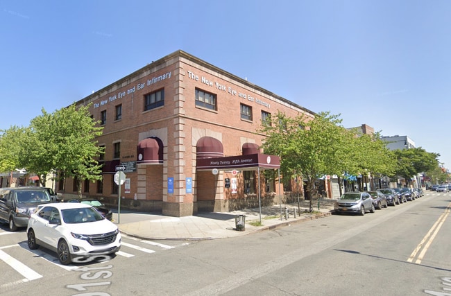
Property Record
9020-9024 5Th Ave, Brooklyn, NY 11209

Current Lease Availabilities
NEARBY LISTINGS FOR SALE OR LEASE
Property Detail
9020-9024 5Th Ave
06082-0029
DOCID-2021021800199001
Funeralhome
Kings
X
New York
3604970332F
27
2024
0.06 AC
2025
South Brooklyn
005800
Long Island (New York)
6,500 SF
New York-Jersey City-White Plains, NY-NJ
DEMOGRAPHICS near 9020-9024 5Th Ave
1 mile
3 mile
5 mile
2024 Total Population
69,192
547,922
1,395,353
2029 Population
64,447
505,080
1,312,627
Pop Growth 2024-2029
(6.86%)
(7.82%)
(5.93%)
Average Age
43
38
40
2024 Total Households
28,638
177,043
495,019
HH Growth 2024-2029
(7.17%)
(8.13%)
(6.17%)
Median Household Inc
$84,987
$62,038
$69,631
Avg Household Size
2.40
2.90
2.70
2024 Avg HH Vehicles
1.00
1.00
1.00
Median Home Value
$908,732
$855,285
$813,217
Median Year Built
1946
1947
1948
Nearby Places
Map Layers
Map Styles
 Street
 Aerial
Transit
 Traffic
 Biking
Places
Listings with unknown addresses are not visible on the map
- Restaurants
- Banks
- Shops
- Fitness
- Groceries
PUBLIC TRANSPORTATION
TRANSIT/SUBWAY
Bay Ridge-95 Street (R - New York MTA Subway (The Subway))
Drive
Walk
Distance
Bay Ridge-95 Street (R - New York MTA Subway (The Subway))
2 min
5 min
0.2 mi
86 Street (R Line) (R - New York MTA Subway (The Subway))
Drive
Walk
Distance
86 Street (R Line) (R - New York MTA Subway (The Subway))
2 min
7 min
0.4 mi
77 Street (R Line) (R - New York MTA Subway (The Subway))
Drive
Walk
Distance
77 Street (R Line) (R - New York MTA Subway (The Subway))
3 min
17 min
0.8 mi
COMMUTER RAIL
Flatbush Avenue Station (Far Rockaway Branch - Long Island Rail Road, Hempstead Branch - Long Island Rail Road, Long Beach Branch - Long Island Rail Road, West Hempstead Branch - Long Island Rail Road)
Drive
Walk
Distance
Flatbush Avenue Station (Far Rockaway Branch - Long Island Rail Road, Hempstead Branch - Long Island Rail Road, Long Beach Branch - Long Island Rail Road, West Hempstead Branch - Long Island Rail Road)
14 min
7.8 mi
Nostrand Avenue Station (Far Rockaway Branch - Long Island Rail Road, Hempstead Branch - Long Island Rail Road, Long Beach Branch - Long Island Rail Road, West Hempstead Branch - Long Island Rail Road)
Drive
Walk
Distance
Nostrand Avenue Station (Far Rockaway Branch - Long Island Rail Road, Hempstead Branch - Long Island Rail Road, Long Beach Branch - Long Island Rail Road, West Hempstead Branch - Long Island Rail Road)
22 min
9.1 mi
AIRPORT
LaGuardia
Drive
Walk
Distance
LaGuardia
26 min
17.2 mi
John F Kennedy International
Drive
Walk
Distance
John F Kennedy International
29 min
20.2 mi
Newark Liberty International
Drive
Walk
Distance
Newark Liberty International
20 min
20.3 mi
Nearby Properties
Address
Land Use
TOTAL SIZE
Lot Size
Zoning
Address
Land Use
TOTAL SIZE
Lot Size
Zoning
1,524,659 SF
170.96 AC
R4
Address
Land Use
TOTAL SIZE
Lot Size
Zoning
965,600 SF
6.65 AC
R5
Address
Land Use
TOTAL SIZE
Lot Size
Zoning
460,000 SF
3.21 AC
R6
Address
Land Use
TOTAL SIZE
Lot Size
Zoning
305,093 SF
0.60 AC
C1-9
Address
Land Use
TOTAL SIZE
Lot Size
Zoning
335,800 SF
1.51 AC
R6
Address
Land Use
TOTAL SIZE
Lot Size
Zoning
340,837 SF
0.61 AC
C1-9
Address
Land Use
TOTAL SIZE
Lot Size
Zoning
1,324,592 SF
5.13 AC
M3-1
Address
Land Use
TOTAL SIZE
Lot Size
Zoning
397,354 SF
0.61 AC
C5-2
Address
Land Use
TOTAL SIZE
Lot Size
Zoning
340,068 SF
0.58 AC
C2-8
Address
Land Use
TOTAL SIZE
Lot Size
Zoning
340,068 SF
0.58 AC
C2-8
Address
Land Use
TOTAL SIZE
Lot Size
Zoning
236,591 SF
207.66 AC
R3-2
Address
Land Use
TOTAL SIZE
Lot Size
Zoning
537,885 SF
2.98 AC
R8
Address
Land Use
TOTAL SIZE
Lot Size
Zoning
808,372 SF
0.18 AC
R6
Address
Land Use
TOTAL SIZE
Lot Size
Zoning
5,359,400 SF
59.07 AC
M2-1
Address
Land Use
TOTAL SIZE
Lot Size
Zoning
286,000 SF
12.63 AC
PARK
Address
Land Use
TOTAL SIZE
Lot Size
Zoning
370,248 SF
0.52 AC
C1-9
Address
Land Use
TOTAL SIZE
Lot Size
Zoning
418,000 SF
0.78 AC
R10A
Address
Land Use
TOTAL SIZE
Lot Size
Zoning
3,970,000 SF
91.14 AC
M3-1
Address
Land Use
TOTAL SIZE
Lot Size
Zoning
689,850 SF
3.08 AC
M3-1
Address
Land Use
TOTAL SIZE
Lot Size
Zoning
301,400 SF
22.27 AC
M3-1
Address
Land Use
TOTAL SIZE
Lot Size
Zoning
673,895 SF
3.22 AC
M3-1
Address
Land Use
TOTAL SIZE
Lot Size
Zoning
310,068 SF
0.58 AC
C2-8
Address
Land Use
TOTAL SIZE
Lot Size
Zoning
421,800 SF
2.35 AC
R6
Address
Land Use
TOTAL SIZE
Lot Size
Zoning
421,800 SF
2.35 AC
R6
Address
Land Use
TOTAL SIZE
Lot Size
Zoning
421,800 SF
2.35 AC
R6
Address
Land Use
TOTAL SIZE
Lot Size
Zoning
492,962 SF
8.12 AC
M1-1
Address
Land Use
TOTAL SIZE
Lot Size
Zoning
139,557 SF
11.47 AC
M1-1
Address
Land Use
TOTAL SIZE
Lot Size
Zoning
623,117 SF
4.16 AC
M3-1
Address
Land Use
TOTAL SIZE
Lot Size
Zoning
171,591 SF
0.14 AC
C5-2
Address
Land Use
TOTAL SIZE
Lot Size
Zoning
305,093 SF
0.60 AC
C1-9
The World's #1 Commercial Real Estate Marketplace
Connect with us
© 2026 CoStar Group
The information above has been obtained from sources believed reliable. While we do not doubt its accuracy we have not verified it and make no guarantee, warranty or representation about it. It is your responsibility to independently confirm its accuracy and completeness. Any projections, opinions, assumptions, or estimates used are for example only and do not represent the current or future performance of the property. The value of this transaction to you depends on tax and other factors which should be evaluated by your tax, financial, and legal advisors. You and your advisors should conduct a careful, independent investigation of the property to determine to your satisfaction the suitability of the property for your needs.