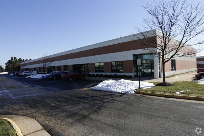
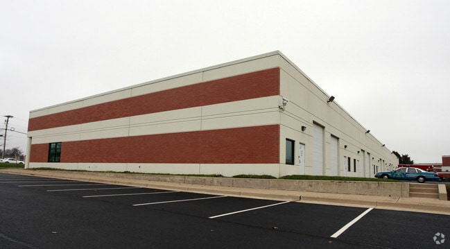
Property Record
9021 Euclid Ave, Manassas, VA 20110

Property Detail
9021 Euclid Ave
Warehouse
COMMERCIAL
LIGHT INDU
MANASSAS CITY
B and X Area of moderate flood hazard, usually the area between the limits of the 100-year and 500-year floods.
Virginia
2025
Manassas
2025
Washington, DC
910301
Washington-Arlington-Alexandria, DC-VA-MD-WV
36,627 SF
111-01-00-14F
NEARBY LISTINGS FOR SALE OR LEASE
DEMOGRAPHICS near 9021 Euclid Ave
1 mile
3 mile
5 mile
2025 Total Population
17,953
99,345
174,600
2030 Population
18,052
101,009
177,878
Pop Growth 2025-2030
+ 0.55%
+ 1.67%
+ 1.88%
Average Age
36
36
37
2025 Total Households
6,269
30,778
55,857
HH Growth 2025-2030
+ 0.43%
+ 1.66%
+ 1.89%
Median Household Inc
$107,135
$112,603
$117,949
Avg Household Size
2.80
3.10
3.00
2025 Avg HH Vehicles
2.00
2.00
2.00
Median Home Value
$441,729
$459,189
$489,411
Median Year Built
1993
1985
1987
Nearby Places
Map Layers
Map Styles
 Street
 Aerial
Layers
 Traffic
 Biking
Places
Listings with unknown addresses are not visible on the map
- Restaurants
- Banks
- Shops
- Fitness
- Groceries
PUBLIC TRANSPORTATION
COMMUTER RAIL
Manassas Amtrak Station (Cardinal - Amtrak, Crescent - Amtrak, Manassas Line - Amtrak, Northeast Regional - Amtrak)
Drive
Walk
Distance
Manassas Amtrak Station (Cardinal - Amtrak, Crescent - Amtrak, Manassas Line - Amtrak, Northeast Regional - Amtrak)
6 min
2.0 mi
Lead (Manassas Line - Virginia Railway Express)
Drive
Walk
Distance
Lead (Manassas Line - Virginia Railway Express)
16 min
6.0 mi
AIRPORT
Washington Dulles International
Drive
Walk
Distance
Washington Dulles International
33 min
17.7 mi
Ronald Reagan Washington Ntl
Drive
Walk
Distance
Ronald Reagan Washington Ntl
48 min
32.4 mi
Freight Ports
Port of Baltimore
Drive
Walk
Distance
Port of Baltimore
93 min
68.2 mi
SALE & LEASE HISTORY
LISTING DATE
SALE/LEASE

May 08, 2020
For Lease
Nearby Properties
Address
Land Use
TOTAL SIZE
Lot Size
Zoning
Address
Land Use
TOTAL SIZE
Lot Size
Zoning
382,368 SF
18.40 AC
PMR
Address
Land Use
TOTAL SIZE
Lot Size
Zoning
402,295 SF
8.50 AC
A1
Address
Land Use
TOTAL SIZE
Lot Size
Zoning
23.93 AC
PUD
Address
Land Use
TOTAL SIZE
Lot Size
Zoning
203,544 SF
20.90 AC
GENERAL CO
Address
Land Use
TOTAL SIZE
Lot Size
Zoning
243,217 SF
LIGHT INDU
Address
Land Use
TOTAL SIZE
Lot Size
Zoning
529,436 SF
24.63 AC
MIXED
Address
Land Use
TOTAL SIZE
Lot Size
Zoning
10.62 AC
PUD
Address
Land Use
TOTAL SIZE
Lot Size
Zoning
18,128 SF
MULTI-FAMI
Address
Land Use
TOTAL SIZE
Lot Size
Zoning
213,662 SF
22.18 AC
R16
Address
Land Use
TOTAL SIZE
Lot Size
Zoning
198,708 SF
16.21 AC
MULTI-FAMI
Address
Land Use
TOTAL SIZE
Lot Size
Zoning
349,608 SF
60.83 AC
A1
Address
Land Use
TOTAL SIZE
Lot Size
Zoning
31,032 SF
15.29 AC
MULTI-FAMI
Address
Land Use
TOTAL SIZE
Lot Size
Zoning
3.49 AC
MU-D
Address
Land Use
TOTAL SIZE
Lot Size
Zoning
205,000 SF
37.08 AC
LOW DENSIT
Address
Land Use
TOTAL SIZE
Lot Size
Zoning
3.41 AC
MU-D
Address
Land Use
TOTAL SIZE
Lot Size
Zoning
140,188 SF
12.76 AC
CITY CENTE
Address
Land Use
TOTAL SIZE
Lot Size
Zoning
325,000 SF
27.97 AC
SMALL LOTS
Address
Land Use
TOTAL SIZE
Lot Size
Zoning
45,585 SF
17.95 AC
GENERAL CO
Address
Land Use
TOTAL SIZE
Lot Size
Zoning
74,450 SF
2.91 AC
CITY CENTE
Address
Land Use
TOTAL SIZE
Lot Size
Zoning
159,940 SF
30 AC
R4
Address
Land Use
TOTAL SIZE
Lot Size
Zoning
71,303 SF
0.54 AC
GENERAL CO
Address
Land Use
TOTAL SIZE
Lot Size
Zoning
8,562 SF
13.50 AC
MULTI-FAMI
Address
Land Use
TOTAL SIZE
Lot Size
Zoning
149,911 SF
13.15 AC
MULTI-FAMI
Address
Land Use
TOTAL SIZE
Lot Size
Zoning
54,401 SF
8.56 AC
PLANNED MI
Address
Land Use
TOTAL SIZE
Lot Size
Zoning
89,844 SF
3.53 AC
GENERAL CO
Address
Land Use
TOTAL SIZE
Lot Size
Zoning
150,000 SF
3.50 AC
CITY CENTE
Address
Land Use
TOTAL SIZE
Lot Size
Zoning
86,907 SF
15.29 AC
R4
Address
Land Use
TOTAL SIZE
Lot Size
Zoning
3.43 AC
MU-D
Address
Land Use
TOTAL SIZE
Lot Size
Zoning
73,599 SF
17.11 AC
GENERAL CO
Address
Land Use
TOTAL SIZE
Lot Size
Zoning
106,768 SF
13.28 AC
R4
The World's #1 Commercial Real Estate Marketplace
Connect with us
© 2026 CoStar Group
The information above has been obtained from sources believed reliable. While we do not doubt its accuracy we have not verified it and make no guarantee, warranty or representation about it. It is your responsibility to independently confirm its accuracy and completeness. Any projections, opinions, assumptions, or estimates used are for example only and do not represent the current or future performance of the property. The value of this transaction to you depends on tax and other factors which should be evaluated by your tax, financial, and legal advisors. You and your advisors should conduct a careful, independent investigation of the property to determine to your satisfaction the suitability of the property for your needs.