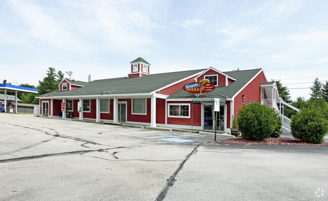
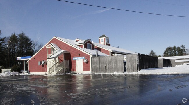
Property Record
903 Londonderry Tpke, Auburn, NH 03032
NEARBY LISTINGS FOR SALE OR LEASE
Property Detail
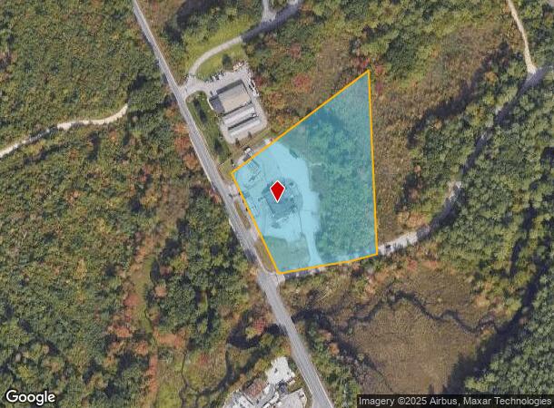
903 Londonderry Tpke
AUBR-000001-000036-000043
Rockingham
Commercialnec
New Hampshire
X
43
33015C0328E
4.47 AC
2024
Rockingham
2024
Boston
004000
Boston-Cambridge-Newton, MA-NH
5,466 SF
DEMOGRAPHICS near 903 Londonderry Tpke
1 Mile
3 Mile
5 Mile
2024 Total Population
1,695
13,938
55,336
2029 Population
1,775
14,550
57,161
Pop Growth 2024-2029
+ 4.72%
+ 4.39%
+ 3.30%
Average Age
40
40
41
2024 Total Households
585
5,206
21,850
HH Growth 2024-2029
+ 4.79%
+ 4.36%
+ 3.21%
Median Household Inc
$138,293
$114,285
$97,864
Avg Household Size
2.80
2.60
2.50
2024 Avg HH Vehicles
2.00
2.00
2.00
Median Home Value
$528,226
$410,498
$359,737
Median Year Built
1986
1989
1980
Nearby Places
Map Layers
Map Styles
 Street
 Aerial
- Restaurants
- Banks
- Shops
- Fitness
- Groceries
PUBLIC TRANSPORTATION
AIRPORT
Manchester Boston Regional
DRIVE
WALK
Distance
Manchester Boston Regional
21 min
9.2 mi
Portsmouth International at Pease
DRIVE
WALK
Distance
Portsmouth International at Pease
63 min
46.6 mi
Freight Ports
Port of Boston
DRIVE
WALK
Distance
Port of Boston
66 min
49.1 mi
Nearby Properties
Address
Land Use
TOTAL SIZE
Lot Size
Zoning
Address
Land Use
TOTAL SIZE
Lot Size
Zoning
366,008 SF
41.69 AC
IND-I
Address
Land Use
TOTAL SIZE
Lot Size
Zoning
487,970 SF
79.74 AC
IND-I
Address
Land Use
TOTAL SIZE
Lot Size
Zoning
119,139 SF
25.87 AC
IND-I
Address
Land Use
TOTAL SIZE
Lot Size
Zoning
6 AC
RURAL
Address
Land Use
TOTAL SIZE
Lot Size
Zoning
125,060 SF
8.76 AC
IND-I
Address
Land Use
TOTAL SIZE
Lot Size
Zoning
722 SF
65 AC
Address
Land Use
TOTAL SIZE
Lot Size
Zoning
13.67 AC
R-III
Address
Land Use
TOTAL SIZE
Lot Size
Zoning
952 SF
199 AC
AR-I
Address
Land Use
TOTAL SIZE
Lot Size
Zoning
768 SF
1.90 AC
Address
Land Use
TOTAL SIZE
Lot Size
Zoning
104.90 AC
Address
Land Use
TOTAL SIZE
Lot Size
Zoning
106,200 SF
3.55 AC
C-II
Address
Land Use
TOTAL SIZE
Lot Size
Zoning
62,164 SF
25.47 AC
IND-I
Address
Land Use
TOTAL SIZE
Lot Size
Zoning
113.28 AC
Address
Land Use
TOTAL SIZE
Lot Size
Zoning
40,974 SF
4.73 AC
C-II
Address
Land Use
TOTAL SIZE
Lot Size
Zoning
7,414 SF
5.32 AC
Address
Land Use
TOTAL SIZE
Lot Size
Zoning
2,866 SF
3.57 AC
Address
Land Use
TOTAL SIZE
Lot Size
Zoning
15,080 SF
9.18 AC
C-II
Address
Land Use
TOTAL SIZE
Lot Size
Zoning
50.27 AC
I-II
Address
Land Use
TOTAL SIZE
Lot Size
Zoning
46,460 SF
6.55 AC
IND-II
Address
Land Use
TOTAL SIZE
Lot Size
Zoning
16,170 SF
10.26 AC
IND-I
Address
Land Use
TOTAL SIZE
Lot Size
Zoning
10.33 AC
I-II
Address
Land Use
TOTAL SIZE
Lot Size
Zoning
24,000 SF
32.17 AC
IND-II
Address
Land Use
TOTAL SIZE
Lot Size
Zoning
460 AC
RESIDE
Address
Land Use
TOTAL SIZE
Lot Size
Zoning
Address
Land Use
TOTAL SIZE
Lot Size
Zoning
22,378 SF
4.09 AC
C-II
Address
Land Use
TOTAL SIZE
Lot Size
Zoning
9.73 AC
I-II
Address
Land Use
TOTAL SIZE
Lot Size
Zoning
36,720 SF
3.82 AC
C-II
Address
Land Use
TOTAL SIZE
Lot Size
Zoning
287 AC
RESIDE
Address
Land Use
TOTAL SIZE
Lot Size
Zoning
Address
Land Use
TOTAL SIZE
Lot Size
Zoning
34,879 SF
6.86 AC
IND-II
The World's #1 Commercial Real Estate Marketplace
Connect with us
© 2026 CoStar Group
The information above has been obtained from sources believed reliable. While we do not doubt its accuracy we have not verified it and make no guarantee, warranty or representation about it. It is your responsibility to independently confirm its accuracy and completeness. Any projections, opinions, assumptions, or estimates used are for example only and do not represent the current or future performance of the property. The value of this transaction to you depends on tax and other factors which should be evaluated by your tax, financial, and legal advisors. You and your advisors should conduct a careful, independent investigation of the property to determine to your satisfaction the suitability of the property for your needs.