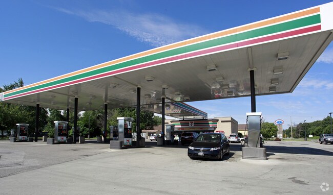
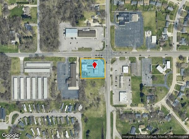
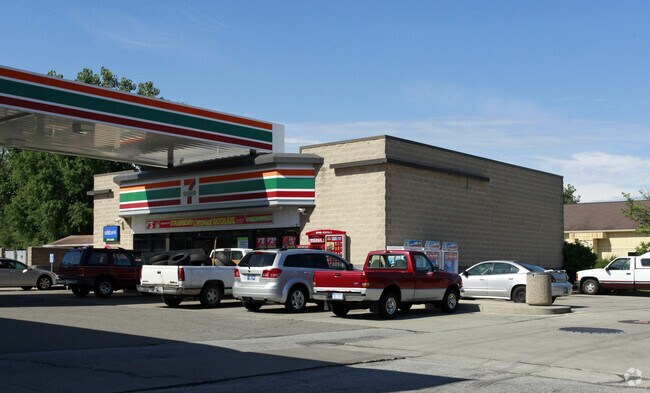
Property Record
903 Mayflower Cir, South Bend, IN 46619
NEARBY LISTINGS FOR SALE OR LEASE
Property Detail
903 Mayflower Cir
South Bend-Mishawaka, IN-MI
Rosenthal Minor
71-08-17-126-004.000-026
LOT 1 ROSENTHAL MINOR
Servicestationmarket
St Joseph
X
Indiana
18141C0187D
1
2023
0.82 AC
2024
Outlying St Joseph County
002600
South Bend/Mishawaka
3,000 SF
DEMOGRAPHICS near 903 Mayflower Cir
1 Mile
3 Mile
5 Mile
2024 Total Population
6,360
35,290
90,534
2029 Population
6,306
35,397
91,038
Pop Growth 2024-2029
(0.85%)
+ 0.30%
+ 0.56%
Average Age
37
37
37
2024 Total Households
2,292
12,694
33,818
HH Growth 2024-2029
(0.92%)
+ 0.18%
+ 0.49%
Median Household Inc
$44,208
$41,121
$47,082
Avg Household Size
2.70
2.60
2.50
2024 Avg HH Vehicles
2.00
2.00
2.00
Median Home Value
$77,777
$81,586
$111,384
Median Year Built
1956
1954
1955
Nearby Places
Map Layers
Map Styles
 Street
 Aerial
- Restaurants
- Banks
- Shops
- Fitness
- Groceries
PUBLIC TRANSPORTATION
COMMUTER RAIL
South Bend Amtrak Station (Capitol Limited - Amtrak, Lake Shore Limited - Amtrak)
DRIVE
WALK
Distance
South Bend Amtrak Station (Capitol Limited - Amtrak, Lake Shore Limited - Amtrak)
6 min
2.9 mi
South Bend Airport Station (South Shore Line - Northern Indiana Commuter Transportation District (South Shore Line))
DRIVE
WALK
Distance
South Bend Airport Station (South Shore Line - Northern Indiana Commuter Transportation District (South Shore Line))
7 min
3.2 mi
AIRPORT
South Bend International
DRIVE
WALK
Distance
South Bend International
14 min
4.1 mi
Freight Ports
Port Milwaukee
DRIVE
WALK
Distance
Port Milwaukee
215 min
172.3 mi
Nearby Properties
Address
Land Use
TOTAL SIZE
Lot Size
Zoning
Address
Land Use
TOTAL SIZE
Lot Size
Zoning
544,872 SF
70.95 AC
Address
Land Use
TOTAL SIZE
Lot Size
Zoning
165,725 SF
0.01 AC
Address
Land Use
TOTAL SIZE
Lot Size
Zoning
85,928 SF
7.83 AC
Address
Land Use
TOTAL SIZE
Lot Size
Zoning
58,135 SF
174 SF
Address
Land Use
TOTAL SIZE
Lot Size
Zoning
164,508 SF
61.83 AC
Address
Land Use
TOTAL SIZE
Lot Size
Zoning
158,495 SF
12.23 AC
Address
Land Use
TOTAL SIZE
Lot Size
Zoning
797,259 SF
45.69 AC
Address
Land Use
TOTAL SIZE
Lot Size
Zoning
45,191 SF
44 SF
Address
Land Use
TOTAL SIZE
Lot Size
Zoning
150,280 SF
21 AC
Address
Land Use
TOTAL SIZE
Lot Size
Zoning
79,602 SF
44 SF
Address
Land Use
TOTAL SIZE
Lot Size
Zoning
92,478 SF
5.10 AC
Address
Land Use
TOTAL SIZE
Lot Size
Zoning
95,436 SF
44 SF
Address
Land Use
TOTAL SIZE
Lot Size
Zoning
93,477 SF
15.53 AC
Address
Land Use
TOTAL SIZE
Lot Size
Zoning
317,436 SF
9.18 AC
Address
Land Use
TOTAL SIZE
Lot Size
Zoning
149,184 SF
21.84 AC
Address
Land Use
TOTAL SIZE
Lot Size
Zoning
282,436 SF
8.77 AC
Address
Land Use
TOTAL SIZE
Lot Size
Zoning
233,224 SF
6.09 AC
Address
Land Use
TOTAL SIZE
Lot Size
Zoning
278,376 SF
13.45 AC
Address
Land Use
TOTAL SIZE
Lot Size
Zoning
131,772 SF
44 SF
Address
Land Use
TOTAL SIZE
Lot Size
Zoning
49,680 SF
44 SF
Address
Land Use
TOTAL SIZE
Lot Size
Zoning
304,652 SF
18.25 AC
Address
Land Use
TOTAL SIZE
Lot Size
Zoning
178,477 SF
8.27 AC
Address
Land Use
TOTAL SIZE
Lot Size
Zoning
35,702 SF
44.52 AC
Address
Land Use
TOTAL SIZE
Lot Size
Zoning
110,604 SF
17.02 AC
Address
Land Use
TOTAL SIZE
Lot Size
Zoning
84,252 SF
8.95 AC
Address
Land Use
TOTAL SIZE
Lot Size
Zoning
151,556 SF
9.13 AC
Address
Land Use
TOTAL SIZE
Lot Size
Zoning
26,016 SF
62 AC
Address
Land Use
TOTAL SIZE
Lot Size
Zoning
296,610 SF
87 SF
Address
Land Use
TOTAL SIZE
Lot Size
Zoning
50,400 SF
2.11 AC
Address
Land Use
TOTAL SIZE
Lot Size
Zoning
82,040 SF
2.54 AC
The World's #1 Commercial Real Estate Marketplace
Connect with us
© 2025 CoStar Group
The information above has been obtained from sources believed reliable. While we do not doubt its accuracy we have not verified it and make no guarantee, warranty or representation about it. It is your responsibility to independently confirm its accuracy and completeness. Any projections, opinions, assumptions, or estimates used are for example only and do not represent the current or future performance of the property. The value of this transaction to you depends on tax and other factors which should be evaluated by your tax, financial, and legal advisors. You and your advisors should conduct a careful, independent investigation of the property to determine to your satisfaction the suitability of the property for your needs.