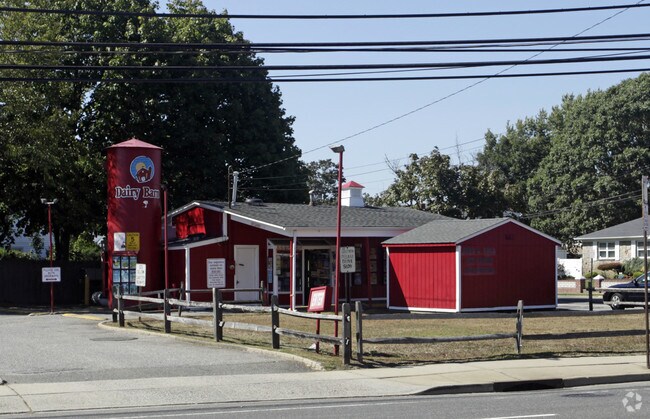
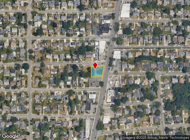
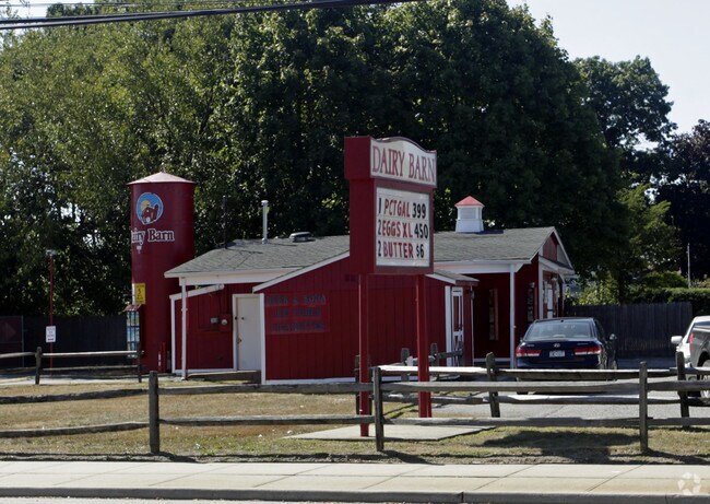
Property Record
903 N Broadway, Massapequa, NY 11758
NEARBY LISTINGS FOR SALE OR LEASE
Property Detail
903 N Broadway
2489-52-097-00-0075-0
TOWN #3 SCH DIST 022
Supermarket
Nassau
X
New York
36103C0830H
75
2025
0.26 AC
2025
Southeast Nassau
521000
Long Island (New York)
442 SF
Nassau County-Suffolk County, NY
DEMOGRAPHICS near 903 N Broadway
1 Mile
3 Mile
5 Mile
2024 Total Population
19,579
171,541
382,762
2029 Population
19,138
168,199
374,959
Pop Growth 2024-2029
(2.25%)
(1.95%)
(2.04%)
Average Age
42
42
42
2024 Total Households
6,506
57,193
126,462
HH Growth 2024-2029
(2.41%)
(2.08%)
(2.18%)
Median Household Inc
$126,292
$128,708
$128,189
Avg Household Size
3.00
2.90
2.90
2024 Avg HH Vehicles
2.00
2.00
2.00
Median Home Value
$649,007
$587,318
$585,919
Median Year Built
1955
1955
1956
Nearby Places
- Restaurants
- Banks
- Shops
- Fitness
- Groceries
PUBLIC TRANSPORTATION
COMMUTER RAIL
Massapequa Station (Babylon Branch - Long Island Rail Road)
DRIVE
WALK
Distance
Massapequa Station (Babylon Branch - Long Island Rail Road)
6 min
2.0 mi
Massapequa Park Station (Babylon Branch - Long Island Rail Road)
DRIVE
WALK
Distance
Massapequa Park Station (Babylon Branch - Long Island Rail Road)
6 min
2.4 mi
AIRPORT
John F Kennedy International
DRIVE
WALK
Distance
John F Kennedy International
32 min
22.0 mi
Long Island MacArthur
DRIVE
WALK
Distance
Long Island MacArthur
33 min
23.9 mi
LaGuardia
DRIVE
WALK
Distance
LaGuardia
42 min
29.0 mi
Freight Ports
NY - Red Hook Container Terminal
DRIVE
WALK
Distance
NY - Red Hook Container Terminal
53 min
33.4 mi
Nearby Properties
Address
Land Use
TOTAL SIZE
Lot Size
Zoning
Address
Land Use
TOTAL SIZE
Lot Size
Zoning
49,840 SF
729.60 AC
Address
Land Use
TOTAL SIZE
Lot Size
Zoning
9.95 AC
BUS3
Address
Land Use
TOTAL SIZE
Lot Size
Zoning
163.85 AC
Address
Land Use
TOTAL SIZE
Lot Size
Zoning
892,140 SF
31.82 AC
Address
Land Use
TOTAL SIZE
Lot Size
Zoning
105,868 SF
198 AC
Address
Land Use
TOTAL SIZE
Lot Size
Zoning
116,514 SF
382 AC
Address
Land Use
TOTAL SIZE
Lot Size
Zoning
4,356 SF
246.70 AC
Address
Land Use
TOTAL SIZE
Lot Size
Zoning
77,270 SF
21.67 AC
Address
Land Use
TOTAL SIZE
Lot Size
Zoning
Address
Land Use
TOTAL SIZE
Lot Size
Zoning
119,692 SF
24.59 AC
Address
Land Use
TOTAL SIZE
Lot Size
Zoning
288 SF
194.85 AC
Address
Land Use
TOTAL SIZE
Lot Size
Zoning
Address
Land Use
TOTAL SIZE
Lot Size
Zoning
22.10 AC
Address
Land Use
TOTAL SIZE
Lot Size
Zoning
17,305 SF
51.61 AC
Address
Land Use
TOTAL SIZE
Lot Size
Zoning
7.15 AC
Address
Land Use
TOTAL SIZE
Lot Size
Zoning
10,072 SF
22.75 AC
Address
Land Use
TOTAL SIZE
Lot Size
Zoning
1,500 SF
125.69 AC
Address
Land Use
TOTAL SIZE
Lot Size
Zoning
348,954 SF
9.98 AC
Address
Land Use
TOTAL SIZE
Lot Size
Zoning
8,000 SF
17.75 AC
Address
Land Use
TOTAL SIZE
Lot Size
Zoning
205,948 SF
15.21 AC
Address
Land Use
TOTAL SIZE
Lot Size
Zoning
120,000 SF
28.96 AC
Address
Land Use
TOTAL SIZE
Lot Size
Zoning
68,555 SF
20.14 AC
Address
Land Use
TOTAL SIZE
Lot Size
Zoning
3,700 SF
43.04 AC
Address
Land Use
TOTAL SIZE
Lot Size
Zoning
76,790 SF
19.32 AC
Address
Land Use
TOTAL SIZE
Lot Size
Zoning
136,804 SF
10.56 AC
Address
Land Use
TOTAL SIZE
Lot Size
Zoning
112,053 SF
16.13 AC
Address
Land Use
TOTAL SIZE
Lot Size
Zoning
28,392 SF
16.58 AC
Address
Land Use
TOTAL SIZE
Lot Size
Zoning
74.90 AC
G
Address
Land Use
TOTAL SIZE
Lot Size
Zoning
157,191 SF
17.70 AC
G
Address
Land Use
TOTAL SIZE
Lot Size
Zoning
0.46 AC
R40
The World's #1 Commercial Real Estate Marketplace
Connect with us
© 2025 CoStar Group
The information above has been obtained from sources believed reliable. While we do not doubt its accuracy we have not verified it and make no guarantee, warranty or representation about it. It is your responsibility to independently confirm its accuracy and completeness. Any projections, opinions, assumptions, or estimates used are for example only and do not represent the current or future performance of the property. The value of this transaction to you depends on tax and other factors which should be evaluated by your tax, financial, and legal advisors. You and your advisors should conduct a careful, independent investigation of the property to determine to your satisfaction the suitability of the property for your needs.