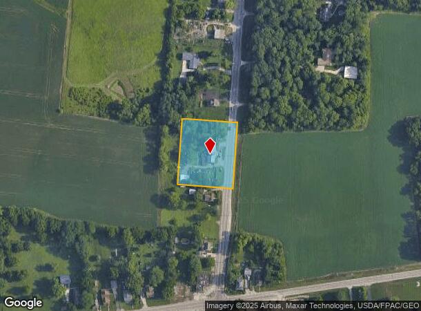
Property Record
9030 S State Route 202, Tipp City, OH 45371
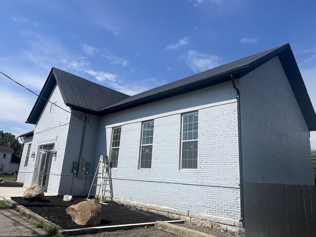
This Property Is For Sale
NEARBY LISTINGS FOR SALE OR LEASE
Property Detail
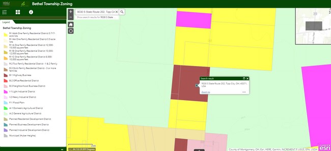
9030 S State Route 202
Dayton, OH
Unincorporated Village Of Phoneton
A01005400
Miami
Sfr
Ohio
X
1.54 AC
39109C0270E
North Dayton
2,520 SF
Cincinnati/Dayton
DEMOGRAPHICS near 9030 S State Route 202
1 Mile
3 Mile
5 Mile
2024 Total Population
3,592
27,949
70,869
2029 Population
3,822
28,292
70,868
Pop Growth 2024-2029
+ 6.40%
+ 1.23%
0.00%
Average Age
39
41
41
2024 Total Households
1,308
10,988
28,692
HH Growth 2024-2029
+ 6.42%
+ 1.06%
(0.09%)
Median Household Inc
$94,457
$84,852
$79,057
Avg Household Size
2.70
2.50
2.40
2024 Avg HH Vehicles
2.00
2.00
2.00
Median Home Value
$375,708
$216,281
$204,967
Median Year Built
2010
1978
1973
Nearby Places
Map Layers
Map Styles
 Street
 Aerial
- Restaurants
- Banks
- Shops
- Fitness
- Groceries
PUBLIC TRANSPORTATION
AIRPORT
James M Cox Dayton International
DRIVE
WALK
Distance
James M Cox Dayton International
15 min
9.6 mi
Nearby Properties
Address
Land Use
TOTAL SIZE
Lot Size
Zoning
Address
Land Use
TOTAL SIZE
Lot Size
Zoning
4,800 SF
0.28 AC
Address
Land Use
TOTAL SIZE
Lot Size
Zoning
0.28 AC
Address
Land Use
TOTAL SIZE
Lot Size
Zoning
97,034 SF
10 AC
Address
Land Use
TOTAL SIZE
Lot Size
Zoning
340,028 SF
37.51 AC
Address
Land Use
TOTAL SIZE
Lot Size
Zoning
74,330 SF
23.79 AC
Address
Land Use
TOTAL SIZE
Lot Size
Zoning
Address
Land Use
TOTAL SIZE
Lot Size
Zoning
135,300 SF
13.75 AC
Address
Land Use
TOTAL SIZE
Lot Size
Zoning
54,740 SF
8.01 AC
Address
Land Use
TOTAL SIZE
Lot Size
Zoning
23,980 SF
9.47 AC
Address
Land Use
TOTAL SIZE
Lot Size
Zoning
425,641 SF
33.79 AC
Address
Land Use
TOTAL SIZE
Lot Size
Zoning
5,809 SF
12.84 AC
Address
Land Use
TOTAL SIZE
Lot Size
Zoning
3,903 SF
5.38 AC
Address
Land Use
TOTAL SIZE
Lot Size
Zoning
3,420 SF
12.59 AC
Address
Land Use
TOTAL SIZE
Lot Size
Zoning
207,442 SF
42.40 AC
Address
Land Use
TOTAL SIZE
Lot Size
Zoning
8,081 SF
8.42 AC
Address
Land Use
TOTAL SIZE
Lot Size
Zoning
Address
Land Use
TOTAL SIZE
Lot Size
Zoning
43,850 SF
13.15 AC
Address
Land Use
TOTAL SIZE
Lot Size
Zoning
179,704 SF
18.68 AC
Address
Land Use
TOTAL SIZE
Lot Size
Zoning
10.25 AC
Address
Land Use
TOTAL SIZE
Lot Size
Zoning
92,985 SF
14.50 AC
Address
Land Use
TOTAL SIZE
Lot Size
Zoning
2,430 SF
371.47 AC
Address
Land Use
TOTAL SIZE
Lot Size
Zoning
126,038 SF
13.78 AC
Address
Land Use
TOTAL SIZE
Lot Size
Zoning
184,413 SF
9.39 AC
Address
Land Use
TOTAL SIZE
Lot Size
Zoning
47,904 SF
2.25 AC
Address
Land Use
TOTAL SIZE
Lot Size
Zoning
16,778 SF
1.89 AC
Address
Land Use
TOTAL SIZE
Lot Size
Zoning
198,560 SF
16.25 AC
Address
Land Use
TOTAL SIZE
Lot Size
Zoning
37,742 SF
19.45 AC
Address
Land Use
TOTAL SIZE
Lot Size
Zoning
23,870 SF
14.27 AC
Address
Land Use
TOTAL SIZE
Lot Size
Zoning
4.68 AC
Address
Land Use
TOTAL SIZE
Lot Size
Zoning
128,585 SF
9.50 AC
The World's #1 Commercial Real Estate Marketplace
Connect with us
© 2026 CoStar Group
The information above has been obtained from sources believed reliable. While we do not doubt its accuracy we have not verified it and make no guarantee, warranty or representation about it. It is your responsibility to independently confirm its accuracy and completeness. Any projections, opinions, assumptions, or estimates used are for example only and do not represent the current or future performance of the property. The value of this transaction to you depends on tax and other factors which should be evaluated by your tax, financial, and legal advisors. You and your advisors should conduct a careful, independent investigation of the property to determine to your satisfaction the suitability of the property for your needs.