Property Record
9032 Hinton Ave, Sparrows Point, MD 21219

Save to a Folder
{{folder.Name}}
{{folder.ListingIds.length}} Properties
{{folder.ListingIds.length}} Property
Create a New Folder
Property Detail
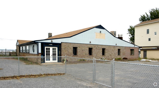
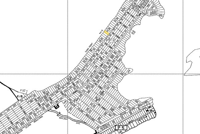
9032 Hinton Ave
15-1520200200
LTS 62,63,64 SWAN POINT
Restaurantbuilding
Baltimore
BL
Maryland
AE The base floodplain where base flood elevations are provided. AE Zones are now used on new format FIRMs instead of A1-A30 Zones.
62
2024
0.51 AC
2025
Baltimore County East
451900
Baltimore
3,675 SF
Baltimore-Columbia-Towson, MD
NEARBY LISTINGS FOR SALE OR LEASE
DEMOGRAPHICS near 9032 Hinton Ave
1 mile
3 mile
5 mile
2025 Total Population
756
10,330
33,439
2030 Population
767
10,479
33,724
Pop Growth 2025-2030
+ 1.46%
+ 1.44%
+ 0.85%
Average Age
46
44
41
2025 Total Households
308
4,110
12,937
HH Growth 2025-2030
+ 1.30%
+ 1.44%
+ 0.91%
Median Household Inc
$162,977
$110,392
$83,260
Avg Household Size
2.40
2.50
2.50
2025 Avg HH Vehicles
2.00
2.00
2.00
Median Home Value
$494,736
$370,254
$321,290
Median Year Built
1987
1962
1962
Nearby Places
Map Layers
Map Styles
 Street
 Aerial
Layers
 Traffic
 Biking
Places
Listings with unknown addresses are not visible on the map
- Restaurants
- Banks
- Shops
- Fitness
- Groceries
PUBLIC TRANSPORTATION
AIRPORT
Baltimore/Washington International Thurgood Marshall
Drive
Walk
Distance
Baltimore/Washington International Thurgood Marshall
37 min
21.1 mi
Freight Ports
Port of Baltimore
Drive
Walk
Distance
Port of Baltimore
32 min
17.7 mi
Nearby Properties
Address
Land Use
TOTAL SIZE
Lot Size
Zoning
Address
Land Use
TOTAL SIZE
Lot Size
Zoning
7,026 SF
1,234.20 AC
DR5.5
Address
Land Use
TOTAL SIZE
Lot Size
Zoning
12.11 AC
DR16
Address
Land Use
TOTAL SIZE
Lot Size
Zoning
197,823 SF
34.32 AC
DR5.5
Address
Land Use
TOTAL SIZE
Lot Size
Zoning
463,050 SF
24.27 AC
ML
Address
Land Use
TOTAL SIZE
Lot Size
Zoning
79.13 AC
DR55
Address
Land Use
TOTAL SIZE
Lot Size
Zoning
33,698 SF
5.69 AC
BLCCC
Address
Land Use
TOTAL SIZE
Lot Size
Zoning
26,400 SF
5.26 AC
DR5.5
Address
Land Use
TOTAL SIZE
Lot Size
Zoning
99,020 SF
5.67 AC
DR5.5
Address
Land Use
TOTAL SIZE
Lot Size
Zoning
11.56 AC
DR3.5
Address
Land Use
TOTAL SIZE
Lot Size
Zoning
20,467 SF
0.66 AC
DR5,5
Address
Land Use
TOTAL SIZE
Lot Size
Zoning
50,892 SF
13.18 AC
DR5.5
Address
Land Use
TOTAL SIZE
Lot Size
Zoning
16,664 SF
0.90 AC
DR5.5
Address
Land Use
TOTAL SIZE
Lot Size
Zoning
4,872 SF
165.55 AC
RC5
Address
Land Use
TOTAL SIZE
Lot Size
Zoning
10,148 SF
3.97 AC
DR5.5
Address
Land Use
TOTAL SIZE
Lot Size
Zoning
18,470 SF
6.86 AC
BLBM
Address
Land Use
TOTAL SIZE
Lot Size
Zoning
2,952 SF
179.68 AC
RC5
Address
Land Use
TOTAL SIZE
Lot Size
Zoning
840 SF
588.14 AC
Address
Land Use
TOTAL SIZE
Lot Size
Zoning
8,176 SF
11.94 AC
Address
Land Use
TOTAL SIZE
Lot Size
Zoning
19,668 SF
2 AC
BL
Address
Land Use
TOTAL SIZE
Lot Size
Zoning
11,572 SF
1.12 AC
DR5.5
Address
Land Use
TOTAL SIZE
Lot Size
Zoning
69.93 AC
Address
Land Use
TOTAL SIZE
Lot Size
Zoning
684 SF
25.31 AC
RC5
Address
Land Use
TOTAL SIZE
Lot Size
Zoning
161.90 AC
Address
Land Use
TOTAL SIZE
Lot Size
Zoning
6,837 SF
4.32 AC
DR5.5
Address
Land Use
TOTAL SIZE
Lot Size
Zoning
5,600 SF
1.49 AC
BL
Address
Land Use
TOTAL SIZE
Lot Size
Zoning
8,765 SF
0.40 AC
BL
Address
Land Use
TOTAL SIZE
Lot Size
Zoning
128.83 AC
Address
Land Use
TOTAL SIZE
Lot Size
Zoning
11,880 SF
0.24 AC
BL
Address
Land Use
TOTAL SIZE
Lot Size
Zoning
10,975 SF
0.78 AC
DR5.5
Address
Land Use
TOTAL SIZE
Lot Size
Zoning
6,012 SF
0.82 AC
The World's #1 Commercial Real Estate Marketplace
Connect with us
© 2026 CoStar Group
The information above has been obtained from sources believed reliable. While we do not doubt its accuracy we have not verified it and make no guarantee, warranty or representation about it. It is your responsibility to independently confirm its accuracy and completeness. Any projections, opinions, assumptions, or estimates used are for example only and do not represent the current or future performance of the property. The value of this transaction to you depends on tax and other factors which should be evaluated by your tax, financial, and legal advisors. You and your advisors should conduct a careful, independent investigation of the property to determine to your satisfaction the suitability of the property for your needs.