Property Record
9039 S Saint Landry Ave, Gonzales, LA 70737


Save to a Folder
{{folder.Name}}
{{folder.ListingIds.length}} Properties
{{folder.ListingIds.length}} Property
Create a New Folder
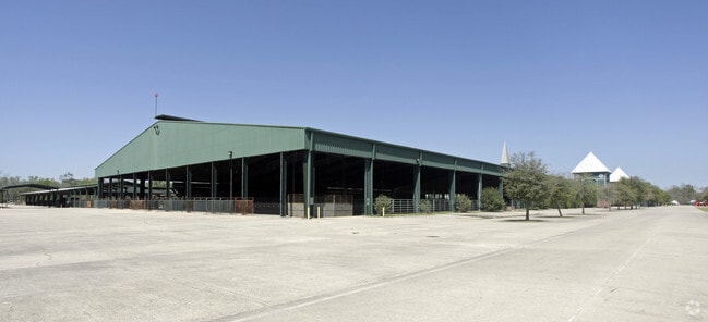
Property Detail
9039 S Saint Landry Ave
Baton Rouge, LA
235.99 ACRES E1/2 OF NE1/4 (LOTS 1 & 2) OF SEC. 80-10-2 & S1/2 OF SE1/4 OF SEC. 1-10-2
20009-155
Ascension
Recreationalentertainmentgeneral
Louisiana
C
1,2
0
235.99 AC
2025
Ascension Parish
030600
Baton Rouge
NEARBY LISTINGS FOR SALE OR LEASE
-
-
View all Gonzales listings for sale on LoopNet.com
DEMOGRAPHICS near 9039 S Saint Landry Ave
1 mile
3 mile
5 mile
2025 Total Population
600
12,117
40,583
2030 Population
653
12,889
42,601
Pop Growth 2025-2030
+ 8.83%
+ 6.37%
+ 4.97%
Average Age
37
38
38
2025 Total Households
228
4,678
15,066
HH Growth 2025-2030
+ 8.77%
+ 6.52%
+ 5.04%
Median Household Inc
$48,026
$72,101
$80,969
Avg Household Size
2.60
2.50
2.60
2025 Avg HH Vehicles
2.00
2.00
2.00
Median Home Value
$335,416
$254,882
$281,769
Median Year Built
2000
2005
2003
Nearby Places
Map Layers
Map Styles
 Street
 Aerial
Layers
 Traffic
 Biking
Places
Listings with unknown addresses are not visible on the map
- Restaurants
- Banks
- Shops
- Fitness
- Groceries
PUBLIC TRANSPORTATION
AIRPORT
Baton Rouge Metro Ryan Field
Drive
Walk
Distance
Baton Rouge Metro Ryan Field
42 min
32.4 mi
Freight Ports
Port of Greater Baton Rouge
Drive
Walk
Distance
Port of Greater Baton Rouge
38 min
27.6 mi
Nearby Properties
Address
Land Use
TOTAL SIZE
Lot Size
Zoning
Address
Land Use
TOTAL SIZE
Lot Size
Zoning
691.78 AC
IND
Address
Land Use
TOTAL SIZE
Lot Size
Zoning
1,564.08 AC
IND
Address
Land Use
TOTAL SIZE
Lot Size
Zoning
32.25 AC
Address
Land Use
TOTAL SIZE
Lot Size
Zoning
Address
Land Use
TOTAL SIZE
Lot Size
Zoning
1,125.77 AC
IND
Address
Land Use
TOTAL SIZE
Lot Size
Zoning
10.83 AC
Address
Land Use
TOTAL SIZE
Lot Size
Zoning
29.24 AC
Address
Land Use
TOTAL SIZE
Lot Size
Zoning
Address
Land Use
TOTAL SIZE
Lot Size
Zoning
Address
Land Use
TOTAL SIZE
Lot Size
Zoning
48.53 AC
C
Address
Land Use
TOTAL SIZE
Lot Size
Zoning
13.83 AC
Address
Land Use
TOTAL SIZE
Lot Size
Zoning
170.02 AC
IND
Address
Land Use
TOTAL SIZE
Lot Size
Zoning
17.57 AC
Address
Land Use
TOTAL SIZE
Lot Size
Zoning
Address
Land Use
TOTAL SIZE
Lot Size
Zoning
34.31 AC
Address
Land Use
TOTAL SIZE
Lot Size
Zoning
25.01 AC
IND
Address
Land Use
TOTAL SIZE
Lot Size
Zoning
13.02 AC
Address
Land Use
TOTAL SIZE
Lot Size
Zoning
8.37 AC
IND
Address
Land Use
TOTAL SIZE
Lot Size
Zoning
7.10 AC
IND
Address
Land Use
TOTAL SIZE
Lot Size
Zoning
10.48 AC
Address
Land Use
TOTAL SIZE
Lot Size
Zoning
1.88 AC
Address
Land Use
TOTAL SIZE
Lot Size
Zoning
Address
Land Use
TOTAL SIZE
Lot Size
Zoning
12.19 AC
Address
Land Use
TOTAL SIZE
Lot Size
Zoning
11.98 AC
Address
Land Use
TOTAL SIZE
Lot Size
Zoning
10.50 AC
BP
Address
Land Use
TOTAL SIZE
Lot Size
Zoning
Address
Land Use
TOTAL SIZE
Lot Size
Zoning
Address
Land Use
TOTAL SIZE
Lot Size
Zoning
Address
Land Use
TOTAL SIZE
Lot Size
Zoning
11.06 AC
The World's #1 Commercial Real Estate Marketplace
Connect with us
© 2026 CoStar Group
The information above has been obtained from sources believed reliable. While we do not doubt its accuracy we have not verified it and make no guarantee, warranty or representation about it. It is your responsibility to independently confirm its accuracy and completeness. Any projections, opinions, assumptions, or estimates used are for example only and do not represent the current or future performance of the property. The value of this transaction to you depends on tax and other factors which should be evaluated by your tax, financial, and legal advisors. You and your advisors should conduct a careful, independent investigation of the property to determine to your satisfaction the suitability of the property for your needs.