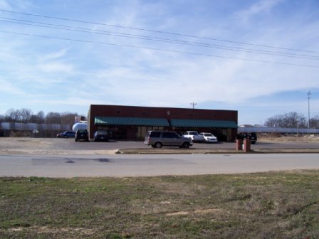
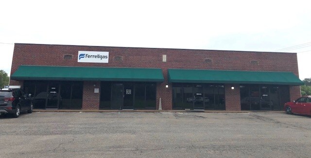
Property Record
9047 Yahweh Rd, Olive Branch, MS 38654

NEARBY LISTINGS FOR SALE OR LEASE
Property Detail
9047 Yahweh Rd
Memphis, TN-MS-AR
Chickasaw Industrial Park
1064180100000500
CHICKASAW INDUSTRIAL PARK LOT 5
Communitycenter
DeSoto
AE
Mississippi
28033C0101H
5
2025
1.56 AC
2025
DeSoto
070811
Memphis
4,074 SF
DEMOGRAPHICS near 9047 Yahweh Rd
1 Mile
3 Mile
5 Mile
2024 Total Population
2,481
33,823
134,202
2029 Population
2,817
34,870
136,589
Pop Growth 2024-2029
+ 13.54%
+ 3.10%
+ 1.78%
Average Age
40
38
37
2024 Total Households
863
11,945
48,913
HH Growth 2024-2029
+ 13.56%
+ 3.25%
+ 1.82%
Median Household Inc
$100,815
$69,970
$61,089
Avg Household Size
2.90
2.80
2.70
2024 Avg HH Vehicles
2.00
2.00
2.00
Median Home Value
$256,759
$221,220
$195,351
Median Year Built
2010
1991
1987
Nearby Places
Map Layers
Map Styles
 Street
 Aerial
- Restaurants
- Banks
- Shops
- Fitness
- Groceries
PUBLIC TRANSPORTATION
AIRPORT
Memphis International
DRIVE
WALK
Distance
Memphis International
19 min
9.3 mi
SALE & LEASE HISTORY
LISTING DATE
SALE/LEASE

Oct 15, 2020
For Lease
Nearby Properties
Address
Land Use
TOTAL SIZE
Lot Size
Zoning
Address
Land Use
TOTAL SIZE
Lot Size
Zoning
863,591 SF
35.66 AC
EMP
Address
Land Use
TOTAL SIZE
Lot Size
Zoning
921,576 SF
25.20 AC
CA
Address
Land Use
TOTAL SIZE
Lot Size
Zoning
834,463 SF
37.46 AC
EMP
Address
Land Use
TOTAL SIZE
Lot Size
Zoning
794,452 SF
39.72 AC
EMP
Address
Land Use
TOTAL SIZE
Lot Size
Zoning
1,403,383 SF
93.69 AC
IH
Address
Land Use
TOTAL SIZE
Lot Size
Zoning
498,764 SF
22.57 AC
CA
Address
Land Use
TOTAL SIZE
Lot Size
Zoning
571,642 SF
23.56 AC
EMP
Address
Land Use
TOTAL SIZE
Lot Size
Zoning
1,292,907 SF
83.13 AC
IH
Address
Land Use
TOTAL SIZE
Lot Size
Zoning
461,807 SF
28.93 AC
EMP
Address
Land Use
TOTAL SIZE
Lot Size
Zoning
434,122 SF
23.97 AC
R-6
Address
Land Use
TOTAL SIZE
Lot Size
Zoning
861,322 SF
72.92 AC
CA
Address
Land Use
TOTAL SIZE
Lot Size
Zoning
1,155,303 SF
61.73 AC
IH
Address
Land Use
TOTAL SIZE
Lot Size
Zoning
158,366 SF
24.31 AC
R-6
Address
Land Use
TOTAL SIZE
Lot Size
Zoning
16,432 SF
445 AC
EMP
Address
Land Use
TOTAL SIZE
Lot Size
Zoning
326,743 SF
22.91 AC
R-8
Address
Land Use
TOTAL SIZE
Lot Size
Zoning
345,770 SF
18.13 AC
EMP
Address
Land Use
TOTAL SIZE
Lot Size
Zoning
903,083 SF
45.12 AC
EMP
Address
Land Use
TOTAL SIZE
Lot Size
Zoning
350,298 SF
12.68 AC
EMP
Address
Land Use
TOTAL SIZE
Lot Size
Zoning
330,758 SF
12.09 AC
EMP
Address
Land Use
TOTAL SIZE
Lot Size
Zoning
654,400 SF
46.39 AC
EMP
Address
Land Use
TOTAL SIZE
Lot Size
Zoning
715,375 SF
37.51 AC
EMP
Address
Land Use
TOTAL SIZE
Lot Size
Zoning
714,692 SF
30.88 AC
EMP
Address
Land Use
TOTAL SIZE
Lot Size
Zoning
523,811 SF
19.83 AC
EMP
Address
Land Use
TOTAL SIZE
Lot Size
Zoning
667,793 SF
35.26 AC
IH
Address
Land Use
TOTAL SIZE
Lot Size
Zoning
239,276 SF
17.72 AC
EMP
Address
Land Use
TOTAL SIZE
Lot Size
Zoning
554,282 SF
67.63 AC
IH
Address
Land Use
TOTAL SIZE
Lot Size
Zoning
676,150 SF
35.69 AC
EMP
Address
Land Use
TOTAL SIZE
Lot Size
Zoning
689,307 SF
22.68 AC
EMP
Address
Land Use
TOTAL SIZE
Lot Size
Zoning
670,921 SF
41.71 AC
I-L
Address
Land Use
TOTAL SIZE
Lot Size
Zoning
642,900 SF
29.71 AC
EMP
The World's #1 Commercial Real Estate Marketplace
Connect with us
© 2025 CoStar Group
The information above has been obtained from sources believed reliable. While we do not doubt its accuracy we have not verified it and make no guarantee, warranty or representation about it. It is your responsibility to independently confirm its accuracy and completeness. Any projections, opinions, assumptions, or estimates used are for example only and do not represent the current or future performance of the property. The value of this transaction to you depends on tax and other factors which should be evaluated by your tax, financial, and legal advisors. You and your advisors should conduct a careful, independent investigation of the property to determine to your satisfaction the suitability of the property for your needs.