Property Record
905 Byron Rd, Hudsonville, MI 49426
NEARBY LISTINGS FOR SALE OR LEASE
-
-
View all Hudsonville listings for sale on LoopNet.com
Property Detail
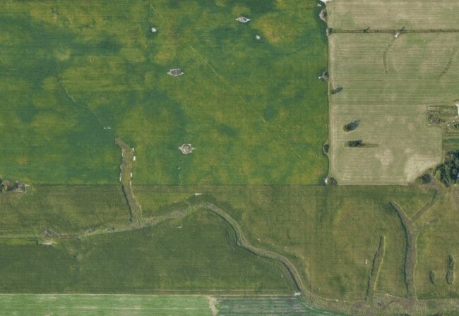
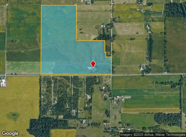
905 Byron Rd
70-18-14-400-015
SE 1/4 EXC NE 1/4 OF SE 1/4, ALSO EXC E 260 FT OF N 450 FT OF SE 1/4 OF SE 1/4 ALSO EXC E 2178 FT OF S 175 FT OF N 625 FT OF
Agriculturalland
Ottawa
X
Michigan
26005C0100G
114.77 AC
2025
E Ottawa Cnty/Hudsonville
2025
West Michigan
021802
Grand Rapids-Wyoming, MI
DEMOGRAPHICS near 905 Byron Rd
1 Mile
3 Mile
5 Mile
2024 Total Population
523
9,593
46,817
2029 Population
549
10,019
48,628
Pop Growth 2024-2029
+ 4.97%
+ 4.44%
+ 3.87%
Average Age
37
35
39
2024 Total Households
166
3,101
16,534
HH Growth 2024-2029
+ 4.82%
+ 4.48%
+ 4.00%
Median Household Inc
$92,856
$93,958
$89,397
Avg Household Size
3.10
3.10
2.80
2024 Avg HH Vehicles
2.00
2.00
2.00
Median Home Value
$314,474
$316,612
$293,854
Median Year Built
1995
2001
1996
Nearby Places
Map Layers
Map Styles
 Street
 Aerial
- Restaurants
- Banks
- Shops
- Fitness
- Groceries
PUBLIC TRANSPORTATION
AIRPORT
Gerald R Ford International
DRIVE
WALK
Distance
Gerald R Ford International
29 min
18.9 mi
Freight Ports
Port Milwaukee
DRIVE
WALK
Distance
Port Milwaukee
294 min
250.5 mi
Nearby Properties
Address
Land Use
TOTAL SIZE
Lot Size
Zoning
Address
Land Use
TOTAL SIZE
Lot Size
Zoning
8,464 SF
80.47 AC
SEE MAP
Address
Land Use
TOTAL SIZE
Lot Size
Zoning
11.56 AC
SEE MAP
Address
Land Use
TOTAL SIZE
Lot Size
Zoning
32,400 SF
67.30 AC
SEE MAP
Address
Land Use
TOTAL SIZE
Lot Size
Zoning
32,163 SF
8.23 AC
Address
Land Use
TOTAL SIZE
Lot Size
Zoning
1,448 SF
40.81 AC
SEE MAP
Address
Land Use
TOTAL SIZE
Lot Size
Zoning
78.89 AC
SEE MAP
Address
Land Use
TOTAL SIZE
Lot Size
Zoning
192.21 AC
SEE MAP
Address
Land Use
TOTAL SIZE
Lot Size
Zoning
2,262 SF
154.14 AC
SEE MAP
Address
Land Use
TOTAL SIZE
Lot Size
Zoning
7,006 SF
1.80 AC
Address
Land Use
TOTAL SIZE
Lot Size
Zoning
151.03 AC
SEE MAP
Address
Land Use
TOTAL SIZE
Lot Size
Zoning
147.65 AC
SEE MAP
Address
Land Use
TOTAL SIZE
Lot Size
Zoning
72.85 AC
SEE MAP
Address
Land Use
TOTAL SIZE
Lot Size
Zoning
201 SF
132.01 AC
SEE MAP
Address
Land Use
TOTAL SIZE
Lot Size
Zoning
12,800 SF
78.35 AC
SEE MAP
Address
Land Use
TOTAL SIZE
Lot Size
Zoning
119.91 AC
SEE MAP
Address
Land Use
TOTAL SIZE
Lot Size
Zoning
3,595 SF
54.80 AC
RA
Address
Land Use
TOTAL SIZE
Lot Size
Zoning
1,920 SF
100.88 AC
SEE MAP
Address
Land Use
TOTAL SIZE
Lot Size
Zoning
2,977 SF
23.29 AC
SEE MAP
Address
Land Use
TOTAL SIZE
Lot Size
Zoning
109.21 AC
SEE MAP
Address
Land Use
TOTAL SIZE
Lot Size
Zoning
34,004 SF
93.03 AC
SEE MAP
Address
Land Use
TOTAL SIZE
Lot Size
Zoning
1,588 SF
80.17 AC
SEE MAP
Address
Land Use
TOTAL SIZE
Lot Size
Zoning
87.40 AC
SEE MAP
Address
Land Use
TOTAL SIZE
Lot Size
Zoning
101.22 AC
SEE MAP
Address
Land Use
TOTAL SIZE
Lot Size
Zoning
98.61 AC
SEE MAP
Address
Land Use
TOTAL SIZE
Lot Size
Zoning
2,020 SF
55.08 AC
SEE MAP
Address
Land Use
TOTAL SIZE
Lot Size
Zoning
95.19 AC
SEE MAP
Address
Land Use
TOTAL SIZE
Lot Size
Zoning
1,692 SF
104.35 AC
SEE MAP
Address
Land Use
TOTAL SIZE
Lot Size
Zoning
1,260 SF
80.50 AC
SEE MAP
Address
Land Use
TOTAL SIZE
Lot Size
Zoning
88.45 AC
SEE MAP
The World's #1 Commercial Real Estate Marketplace
Connect with us
© 2026 CoStar Group
The information above has been obtained from sources believed reliable. While we do not doubt its accuracy we have not verified it and make no guarantee, warranty or representation about it. It is your responsibility to independently confirm its accuracy and completeness. Any projections, opinions, assumptions, or estimates used are for example only and do not represent the current or future performance of the property. The value of this transaction to you depends on tax and other factors which should be evaluated by your tax, financial, and legal advisors. You and your advisors should conduct a careful, independent investigation of the property to determine to your satisfaction the suitability of the property for your needs.