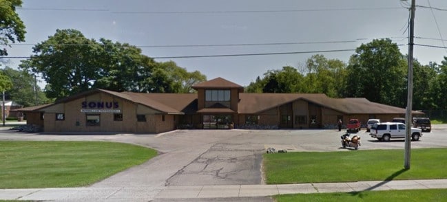
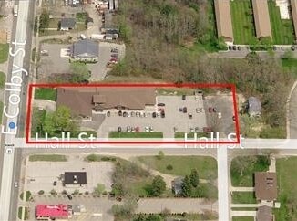
Property Record
905 E Colby St, Whitehall, MI 49461
Property Detail
905 E Colby St
22-270-000-0013-00
SOUTH135 FT LOT13 & S135 FT E15 FT LOT14
Commercialnec
Muskegon
B-1 GEN
Michigan
B and X Area of moderate flood hazard, usually the area between the limits of the 100-year and 500-year floods.
13-14
2024
1.54 AC
2025
Northern Muskegon County
003702
West Michigan
15,846 SF
Muskegon-Norton Shores, MI
NEARBY LISTINGS FOR SALE OR LEASE
-
-
View all Whitehall listings for sale on LoopNet.com
DEMOGRAPHICS near 905 E Colby St
1 mile
3 mile
5 mile
2025 Total Population
2,342
9,286
15,280
2030 Population
2,358
9,505
15,672
Pop Growth 2025-2030
+ 0.68%
+ 2.36%
+ 2.57%
Average Age
44
44
44
2025 Total Households
1,021
3,879
6,194
HH Growth 2025-2030
+ 0.69%
+ 2.40%
+ 2.63%
Median Household Inc
$53,117
$71,020
$74,778
Avg Household Size
2.20
2.40
2.40
2025 Avg HH Vehicles
2.00
2.00
2.00
Median Home Value
$227,160
$243,421
$246,253
Median Year Built
1971
1972
1976
Nearby Places
Map Layers
Map Styles
 Street
 Aerial
Layers
 Traffic
 Biking
Places
Listings with unknown addresses are not visible on the map
- Restaurants
- Banks
- Shops
- Fitness
- Groceries
SALE & LEASE HISTORY
LISTING DATE
SALE/LEASE

Sep 23, 2016
For Sale
Oct 10, 2019
For Sale
Mar 17, 2025
For Sale
Nearby Properties
Address
Land Use
TOTAL SIZE
Lot Size
Zoning
Address
Land Use
TOTAL SIZE
Lot Size
Zoning
620,456 SF
127.38 AC
M-2 GEN
Address
Land Use
TOTAL SIZE
Lot Size
Zoning
104,000 SF
Address
Land Use
TOTAL SIZE
Lot Size
Zoning
126,901 SF
30.35 AC
B COM
Address
Land Use
TOTAL SIZE
Lot Size
Zoning
358,824 SF
38.03 AC
M-1 IND
Address
Land Use
TOTAL SIZE
Lot Size
Zoning
117,661 SF
14.70 AC
M-1 LIM
Address
Land Use
TOTAL SIZE
Lot Size
Zoning
70,092 SF
14.17 AC
C-COM
Address
Land Use
TOTAL SIZE
Lot Size
Zoning
114,008 SF
R - 1
Address
Land Use
TOTAL SIZE
Lot Size
Zoning
183,166 SF
12.83 AC
M-2 GEN
Address
Land Use
TOTAL SIZE
Lot Size
Zoning
28,105 SF
812.04 AC
FR
Address
Land Use
TOTAL SIZE
Lot Size
Zoning
72,461 SF
7.69 AC
M-1 IND
Address
Land Use
TOTAL SIZE
Lot Size
Zoning
52,111 SF
R - 1
Address
Land Use
TOTAL SIZE
Lot Size
Zoning
14,418 SF
2.50 AC
MI LIMI
Address
Land Use
TOTAL SIZE
Lot Size
Zoning
32,945 SF
14.70 AC
Address
Land Use
TOTAL SIZE
Lot Size
Zoning
75,575 SF
5 AC
M-1 LIM
Address
Land Use
TOTAL SIZE
Lot Size
Zoning
41,187 SF
1.50 AC
B COM
Address
Land Use
TOTAL SIZE
Lot Size
Zoning
37,041 SF
12.18 AC
R-1 RES
Address
Land Use
TOTAL SIZE
Lot Size
Zoning
3,332 SF
12.28 AC
RM MULT
Address
Land Use
TOTAL SIZE
Lot Size
Zoning
27,205 SF
3.68 AC
B COM
Address
Land Use
TOTAL SIZE
Lot Size
Zoning
32,717 SF
R - 1
Address
Land Use
TOTAL SIZE
Lot Size
Zoning
23,280 SF
Address
Land Use
TOTAL SIZE
Lot Size
Zoning
35,320 SF
10.88 AC
R-3 RES
Address
Land Use
TOTAL SIZE
Lot Size
Zoning
41,390 SF
9.54 AC
MI LIMI
Address
Land Use
TOTAL SIZE
Lot Size
Zoning
37,368 SF
2.80 AC
B COM
Address
Land Use
TOTAL SIZE
Lot Size
Zoning
78,066 SF
15.24 AC
B COM
Address
Land Use
TOTAL SIZE
Lot Size
Zoning
38,180 SF
3.12 AC
LR-LAKE
Address
Land Use
TOTAL SIZE
Lot Size
Zoning
34,825 SF
6.77 AC
M-1 LIM
Address
Land Use
TOTAL SIZE
Lot Size
Zoning
29,262 SF
2.74 AC
C-1 COM
Address
Land Use
TOTAL SIZE
Lot Size
Zoning
2,359 SF
2.32 AC
LR-LAKE
Address
Land Use
TOTAL SIZE
Lot Size
Zoning
30,300 SF
R - 1
The World's #1 Commercial Real Estate Marketplace
Connect with us
© 2026 CoStar Group
The information above has been obtained from sources believed reliable. While we do not doubt its accuracy we have not verified it and make no guarantee, warranty or representation about it. It is your responsibility to independently confirm its accuracy and completeness. Any projections, opinions, assumptions, or estimates used are for example only and do not represent the current or future performance of the property. The value of this transaction to you depends on tax and other factors which should be evaluated by your tax, financial, and legal advisors. You and your advisors should conduct a careful, independent investigation of the property to determine to your satisfaction the suitability of the property for your needs.