Property Record
905 Irish Rd, Neenah, WI 54956


NEARBY LISTINGS FOR SALE OR LEASE
-
-
View all Neenah listings for sale on LoopNet.com
Property Detail
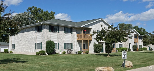
905 Irish Rd
Oshkosh-Neenah, WI
Sunset Village Condominium
008-052401
PT NW SW COM NW COR E 1309.52 FT S 50 FT POB S 396 FT W 696.53 FT N 8.31 FT W 613.03 FT TO WL N 386.96 TO SL OF RR ROW E ALG ROW 1309.73 FT TO POB AS IN D1377210 11.77 A.
Commercialnec
Winnebago
X
Wisconsin
55087C0425D
11.77 AC
2024
Appleton/Oshkosh
2024
Other Market Areas
002401
DEMOGRAPHICS near 905 Irish Rd
1 Mile
3 Mile
5 Mile
2024 Total Population
3,102
31,063
77,106
2029 Population
3,106
31,074
77,446
Pop Growth 2024-2029
+ 0.13%
+ 0.04%
+ 0.44%
Average Age
39
40
40
2024 Total Households
1,271
13,202
32,913
HH Growth 2024-2029
(0.08%)
(0.14%)
+ 0.34%
Median Household Inc
$73,080
$64,435
$66,185
Avg Household Size
2.40
2.30
2.30
2024 Avg HH Vehicles
2.00
2.00
2.00
Median Home Value
$221,280
$178,694
$188,477
Median Year Built
1977
1973
1975
Nearby Places
Map Layers
Map Styles
 Street
 Aerial
- Restaurants
- Banks
- Shops
- Fitness
- Groceries
PUBLIC TRANSPORTATION
AIRPORT
Appleton International
DRIVE
WALK
Distance
Appleton International
13 min
4.4 mi
Green Bay/Austin Straubel International
DRIVE
WALK
Distance
Green Bay/Austin Straubel International
51 min
36.7 mi
Freight Ports
Port of Baltimore
DRIVE
WALK
Distance
Port of Baltimore
990 min
886.2 mi
Nearby Properties
Address
Land Use
TOTAL SIZE
Lot Size
Zoning
Address
Land Use
TOTAL SIZE
Lot Size
Zoning
68.77 AC
Address
Land Use
TOTAL SIZE
Lot Size
Zoning
156.36 AC
M1
Address
Land Use
TOTAL SIZE
Lot Size
Zoning
11.99 AC
Address
Land Use
TOTAL SIZE
Lot Size
Zoning
120.73 AC
M2
Address
Land Use
TOTAL SIZE
Lot Size
Zoning
11.22 AC
Address
Land Use
TOTAL SIZE
Lot Size
Zoning
1,975 SF
2.40 AC
M2
Address
Land Use
TOTAL SIZE
Lot Size
Zoning
9.40 AC
Address
Land Use
TOTAL SIZE
Lot Size
Zoning
11,340 SF
0.92 AC
C2
Address
Land Use
TOTAL SIZE
Lot Size
Zoning
178,750 SF
0.43 AC
C2
Address
Land Use
TOTAL SIZE
Lot Size
Zoning
59,584 SF
12.11 AC
C1
Address
Land Use
TOTAL SIZE
Lot Size
Zoning
103,427 SF
0.56 AC
PDD
Address
Land Use
TOTAL SIZE
Lot Size
Zoning
6.75 AC
M1
Address
Land Use
TOTAL SIZE
Lot Size
Zoning
89,042 SF
2.83 AC
C2
Address
Land Use
TOTAL SIZE
Lot Size
Zoning
10.42 AC
Address
Land Use
TOTAL SIZE
Lot Size
Zoning
89,576 SF
1.03 AC
C2
Address
Land Use
TOTAL SIZE
Lot Size
Zoning
105,852 SF
0.39 AC
PDD
Address
Land Use
TOTAL SIZE
Lot Size
Zoning
15.73 AC
B5
Address
Land Use
TOTAL SIZE
Lot Size
Zoning
210,214 SF
16.44 AC
I1
Address
Land Use
TOTAL SIZE
Lot Size
Zoning
86,455 SF
PDD
Address
Land Use
TOTAL SIZE
Lot Size
Zoning
25.62 AC
I2
Address
Land Use
TOTAL SIZE
Lot Size
Zoning
17.55 AC
A2
Address
Land Use
TOTAL SIZE
Lot Size
Zoning
4.33 AC
Address
Land Use
TOTAL SIZE
Lot Size
Zoning
74,603 SF
4.96 AC
I1
Address
Land Use
TOTAL SIZE
Lot Size
Zoning
7.29 AC
Address
Land Use
TOTAL SIZE
Lot Size
Zoning
92,030 SF
7.79 AC
I1
Address
Land Use
TOTAL SIZE
Lot Size
Zoning
145,322 SF
11.20 AC
PDD
Address
Land Use
TOTAL SIZE
Lot Size
Zoning
10.13 AC
M2
Address
Land Use
TOTAL SIZE
Lot Size
Zoning
32.60 AC
Address
Land Use
TOTAL SIZE
Lot Size
Zoning
31,400 SF
0.37 AC
PDD
The World's #1 Commercial Real Estate Marketplace
Connect with us
© 2025 CoStar Group
The information above has been obtained from sources believed reliable. While we do not doubt its accuracy we have not verified it and make no guarantee, warranty or representation about it. It is your responsibility to independently confirm its accuracy and completeness. Any projections, opinions, assumptions, or estimates used are for example only and do not represent the current or future performance of the property. The value of this transaction to you depends on tax and other factors which should be evaluated by your tax, financial, and legal advisors. You and your advisors should conduct a careful, independent investigation of the property to determine to your satisfaction the suitability of the property for your needs.