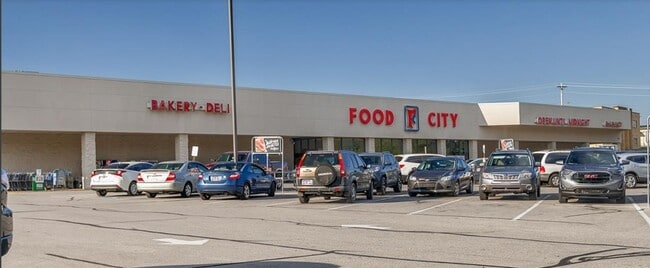
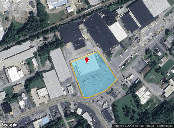
Property Record
905 Snapps Ferry Rd, Greeneville, TN 37745
NEARBY LISTINGS FOR SALE OR LEASE
Property Detail
905 Snapps Ferry Rd
Greeneville, TN
J R Mcamis Heirs Prop
099A-B-020.00
J R MCAMIS HEIRS PROP PB: 3 PG: 3 LOT: 4-9 FOOD CITY #606 LOTS 35-43 448 FR
Commercialnec
Greene
A
Tennessee
47059C0237D
4-9
0
3.67 AC
2025
Tennessee East Area
090400
Other Market Areas
42,552 SF
DEMOGRAPHICS near 905 Snapps Ferry Rd
1 Mile
3 Mile
5 Mile
2024 Total Population
4,797
19,782
30,482
2029 Population
5,070
20,909
32,129
Pop Growth 2024-2029
+ 5.69%
+ 5.70%
+ 5.40%
Average Age
43
42
42
2024 Total Households
2,049
8,248
12,291
HH Growth 2024-2029
+ 5.76%
+ 5.81%
+ 5.54%
Median Household Inc
$57,653
$55,791
$56,345
Avg Household Size
2.20
2.30
2.30
2024 Avg HH Vehicles
2.00
2.00
2.00
Median Home Value
$168,064
$183,739
$183,907
Median Year Built
1968
1973
1975
Nearby Places
Map Layers
Map Styles
 Street
 Aerial
- Restaurants
- Banks
- Shops
- Fitness
- Groceries
SALE & LEASE HISTORY
LISTING DATE
SALE/LEASE

Sep 22, 2022
For Sale
Nearby Properties
Address
Land Use
TOTAL SIZE
Lot Size
Zoning
Address
Land Use
TOTAL SIZE
Lot Size
Zoning
1,070,100 SF
64.36 AC
M1
Address
Land Use
TOTAL SIZE
Lot Size
Zoning
45,288 SF
4.78 AC
MR
Address
Land Use
TOTAL SIZE
Lot Size
Zoning
84,285 SF
4 AC
B4
Address
Land Use
TOTAL SIZE
Lot Size
Zoning
76,554 SF
11.63 AC
A1
Address
Land Use
TOTAL SIZE
Lot Size
Zoning
121,886 SF
15.57 AC
B4
Address
Land Use
TOTAL SIZE
Lot Size
Zoning
24.06 AC
A1
Address
Land Use
TOTAL SIZE
Lot Size
Zoning
2,160 SF
6.96 AC
B4
Address
Land Use
TOTAL SIZE
Lot Size
Zoning
49,789 SF
7.95 AC
Address
Land Use
TOTAL SIZE
Lot Size
Zoning
76,206 SF
18.08 AC
R4
Address
Land Use
TOTAL SIZE
Lot Size
Zoning
111,495 SF
9.82 AC
M2
Address
Land Use
TOTAL SIZE
Lot Size
Zoning
57,390 SF
Address
Land Use
TOTAL SIZE
Lot Size
Zoning
28,476 SF
7.30 AC
M1
Address
Land Use
TOTAL SIZE
Lot Size
Zoning
49,276 SF
4 AC
Address
Land Use
TOTAL SIZE
Lot Size
Zoning
134,526 SF
14.71 AC
B4
Address
Land Use
TOTAL SIZE
Lot Size
Zoning
4,367 SF
10.20 AC
B4
Address
Land Use
TOTAL SIZE
Lot Size
Zoning
389,266 SF
20.78 AC
A1
Address
Land Use
TOTAL SIZE
Lot Size
Zoning
50,806 SF
6.14 AC
A1
Address
Land Use
TOTAL SIZE
Lot Size
Zoning
39,910 SF
5.50 AC
A1
Address
Land Use
TOTAL SIZE
Lot Size
Zoning
64,800 SF
A1
Address
Land Use
TOTAL SIZE
Lot Size
Zoning
51,265 SF
4 AC
Address
Land Use
TOTAL SIZE
Lot Size
Zoning
9,002 SF
7.99 AC
Address
Land Use
TOTAL SIZE
Lot Size
Zoning
11,250 SF
13.31 AC
B4
Address
Land Use
TOTAL SIZE
Lot Size
Zoning
35,584 SF
3.29 AC
B4
Address
Land Use
TOTAL SIZE
Lot Size
Zoning
153,422 SF
19.56 AC
M1
Address
Land Use
TOTAL SIZE
Lot Size
Zoning
70,123 SF
1.10 AC
A1
Address
Land Use
TOTAL SIZE
Lot Size
Zoning
44,415 SF
5.23 AC
A1
Address
Land Use
TOTAL SIZE
Lot Size
Zoning
11,016 SF
6.50 AC
B4
Address
Land Use
TOTAL SIZE
Lot Size
Zoning
165,500 SF
23 AC
M1
Address
Land Use
TOTAL SIZE
Lot Size
Zoning
27,117 SF
2.77 AC
A1
Address
Land Use
TOTAL SIZE
Lot Size
Zoning
67,200 SF
11.88 AC
M1
The World's #1 Commercial Real Estate Marketplace
Connect with us
© 2026 CoStar Group
The information above has been obtained from sources believed reliable. While we do not doubt its accuracy we have not verified it and make no guarantee, warranty or representation about it. It is your responsibility to independently confirm its accuracy and completeness. Any projections, opinions, assumptions, or estimates used are for example only and do not represent the current or future performance of the property. The value of this transaction to you depends on tax and other factors which should be evaluated by your tax, financial, and legal advisors. You and your advisors should conduct a careful, independent investigation of the property to determine to your satisfaction the suitability of the property for your needs.