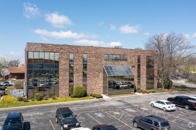
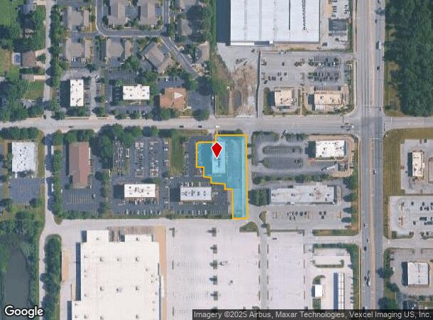
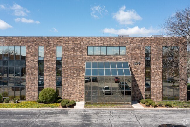
Property Record
905 175Th St, Homewood, IL 60430

Current Lease Availabilities
NEARBY LISTINGS FOR SALE OR LEASE
Property Detail
905 175Th St
Chicago-Naperville-Elgin, IL-IN-WI
Ginsburg Sub
29-32-200-043-0000
(GINSBURG) SUB IN THE NE SEC 32-36-14
Storebuilding
Cook
X
Illinois
17031C0734J
1
2023
1.06 AC
2024
Far South
828402
Chicago
22,368 SF
DEMOGRAPHICS near 905 175Th St
1 Mile
3 Mile
5 Mile
2024 Total Population
4,159
74,240
227,130
2029 Population
4,049
72,808
223,179
Pop Growth 2024-2029
(2.64%)
(1.93%)
(1.74%)
Average Age
44
41
40
2024 Total Households
1,880
26,929
82,191
HH Growth 2024-2029
(2.93%)
(2.26%)
(2.07%)
Median Household Inc
$46,681
$63,456
$58,164
Avg Household Size
2.20
2.70
2.70
2024 Avg HH Vehicles
1.00
2.00
2.00
Median Home Value
$132,051
$151,332
$147,074
Median Year Built
1964
1962
1965
Nearby Places
- Restaurants
- Banks
- Shops
- Fitness
- Groceries
PUBLIC TRANSPORTATION
COMMUTER RAIL
Hazel Crest Station (Metra Electric Line - Northeast Illinois Regional Commuter Railroad (Metra))
DRIVE
WALK
Distance
Hazel Crest Station (Metra Electric Line - Northeast Illinois Regional Commuter Railroad (Metra))
5 min
1.9 mi
Homewood Station (Metra Electric Line - Northeast Illinois Regional Commuter Railroad (Metra))
DRIVE
WALK
Distance
Homewood Station (Metra Electric Line - Northeast Illinois Regional Commuter Railroad (Metra))
6 min
2.3 mi
AIRPORT
Chicago Midway International
DRIVE
WALK
Distance
Chicago Midway International
31 min
19.8 mi
Chicago O'Hare International
DRIVE
WALK
Distance
Chicago O'Hare International
56 min
41.5 mi
Nearby Properties
Address
Land Use
TOTAL SIZE
Lot Size
Zoning
Address
Land Use
TOTAL SIZE
Lot Size
Zoning
1.45 AC
Address
Land Use
TOTAL SIZE
Lot Size
Zoning
Address
Land Use
TOTAL SIZE
Lot Size
Zoning
244,665 SF
9.05 AC
Address
Land Use
TOTAL SIZE
Lot Size
Zoning
4.85 AC
Address
Land Use
TOTAL SIZE
Lot Size
Zoning
231,296 SF
10.91 AC
Address
Land Use
TOTAL SIZE
Lot Size
Zoning
78,884 SF
5.60 AC
Address
Land Use
TOTAL SIZE
Lot Size
Zoning
196,125 SF
18.55 AC
Address
Land Use
TOTAL SIZE
Lot Size
Zoning
2.86 AC
Address
Land Use
TOTAL SIZE
Lot Size
Zoning
6.19 AC
Address
Land Use
TOTAL SIZE
Lot Size
Zoning
60,864 SF
5.55 AC
Address
Land Use
TOTAL SIZE
Lot Size
Zoning
27,082 SF
0.69 AC
Address
Land Use
TOTAL SIZE
Lot Size
Zoning
52,220 SF
6 AC
Address
Land Use
TOTAL SIZE
Lot Size
Zoning
125,535 SF
9.44 AC
Address
Land Use
TOTAL SIZE
Lot Size
Zoning
49,229 SF
1.31 AC
Address
Land Use
TOTAL SIZE
Lot Size
Zoning
115,250 SF
10.75 AC
Address
Land Use
TOTAL SIZE
Lot Size
Zoning
111,902 SF
8.60 AC
Address
Land Use
TOTAL SIZE
Lot Size
Zoning
233,490 SF
10.19 AC
Address
Land Use
TOTAL SIZE
Lot Size
Zoning
6.34 AC
Address
Land Use
TOTAL SIZE
Lot Size
Zoning
Address
Land Use
TOTAL SIZE
Lot Size
Zoning
6.21 AC
Address
Land Use
TOTAL SIZE
Lot Size
Zoning
0.34 AC
Address
Land Use
TOTAL SIZE
Lot Size
Zoning
180,139 SF
18.78 AC
Address
Land Use
TOTAL SIZE
Lot Size
Zoning
5.42 AC
Address
Land Use
TOTAL SIZE
Lot Size
Zoning
44,189 SF
3.09 AC
Address
Land Use
TOTAL SIZE
Lot Size
Zoning
185,463 SF
10.96 AC
Address
Land Use
TOTAL SIZE
Lot Size
Zoning
Address
Land Use
TOTAL SIZE
Lot Size
Zoning
Address
Land Use
TOTAL SIZE
Lot Size
Zoning
78,075 SF
5.47 AC
Address
Land Use
TOTAL SIZE
Lot Size
Zoning
156,665 SF
3.58 AC
The World's #1 Commercial Real Estate Marketplace
Connect with us
© 2025 CoStar Group
The information above has been obtained from sources believed reliable. While we do not doubt its accuracy we have not verified it and make no guarantee, warranty or representation about it. It is your responsibility to independently confirm its accuracy and completeness. Any projections, opinions, assumptions, or estimates used are for example only and do not represent the current or future performance of the property. The value of this transaction to you depends on tax and other factors which should be evaluated by your tax, financial, and legal advisors. You and your advisors should conduct a careful, independent investigation of the property to determine to your satisfaction the suitability of the property for your needs.