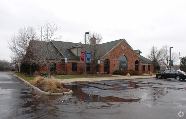
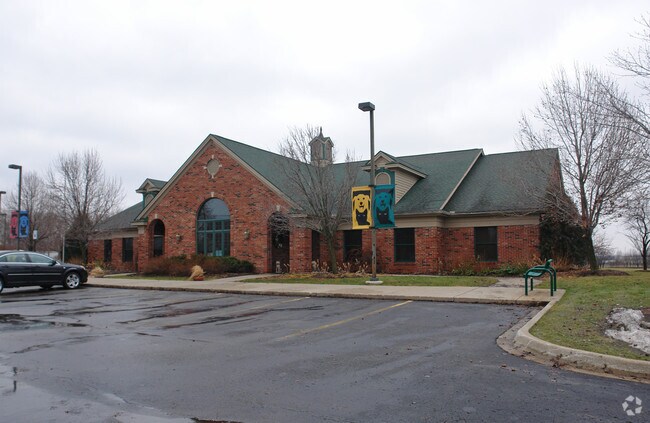
Property Record
9050 Davison Rd, Davison, MI 48423

Property Detail
9050 Davison Rd
05-09-100-006
A POL BEG S 00 DEG 22 MIN E 50 FT & N 89 DEG 31 MIN E 480 FT FROM NW COR OF SEC TH S 00 DEG 22 MIN E 280 FT TH N 89 DEG 31
Commercialnec
Genesee
NOT AVAILA
Michigan
B and X Area of moderate flood hazard, usually the area between the limits of the 100-year and 500-year floods.
1.36 AC
2024
Flint
2025
Detroit
011714
Flint, MI
5,994 SF
NEARBY LISTINGS FOR SALE OR LEASE
DEMOGRAPHICS near 9050 Davison Rd
1 mile
3 mile
5 mile
2025 Total Population
3,465
28,084
49,982
2030 Population
3,436
27,833
49,227
Pop Growth 2025-2030
(0.84%)
(0.89%)
(1.51%)
Average Age
43
42
42
2025 Total Households
1,488
12,275
21,077
HH Growth 2025-2030
(0.74%)
(0.99%)
(1.53%)
Median Household Inc
$63,706
$65,464
$69,444
Avg Household Size
2.30
2.20
2.30
2025 Avg HH Vehicles
2.00
2.00
2.00
Median Home Value
$196,085
$210,252
$190,603
Median Year Built
1969
1980
1974
Nearby Places
Map Layers
Map Styles
 Street
 Aerial
Transit
 Traffic
 Biking
Places
Listings with unknown addresses are not visible on the map
- Restaurants
- Banks
- Shops
- Fitness
- Groceries
PUBLIC TRANSPORTATION
COMMUTER RAIL
Drive
Walk
Distance
13 min
7.6 mi
AIRPORT
Bishop International
Drive
Walk
Distance
Bishop International
30 min
17.1 mi
Nearby Properties
Address
Land Use
TOTAL SIZE
Lot Size
Zoning
Address
Land Use
TOTAL SIZE
Lot Size
Zoning
217,010 SF
18.08 AC
Address
Land Use
TOTAL SIZE
Lot Size
Zoning
51.59 AC
NOT AVAILA
Address
Land Use
TOTAL SIZE
Lot Size
Zoning
46.83 AC
NOT AVAILA
Address
Land Use
TOTAL SIZE
Lot Size
Zoning
34,652 SF
208.43 AC
SRA
Address
Land Use
TOTAL SIZE
Lot Size
Zoning
302,862 SF
27.14 AC
NOT AVAILA
Address
Land Use
TOTAL SIZE
Lot Size
Zoning
157,741 SF
33.61 AC
Address
Land Use
TOTAL SIZE
Lot Size
Zoning
156,996 SF
NOT AVAILA
Address
Land Use
TOTAL SIZE
Lot Size
Zoning
Address
Land Use
TOTAL SIZE
Lot Size
Zoning
19.05 AC
NOT AVAILA
Address
Land Use
TOTAL SIZE
Lot Size
Zoning
159,560 SF
9.96 AC
NOT AVAILA
Address
Land Use
TOTAL SIZE
Lot Size
Zoning
6,449 SF
90.81 AC
MH
Address
Land Use
TOTAL SIZE
Lot Size
Zoning
42,397 SF
15.14 AC
NOT AVAILA
Address
Land Use
TOTAL SIZE
Lot Size
Zoning
56,966 SF
1.81 AC
NOT AVAILA
Address
Land Use
TOTAL SIZE
Lot Size
Zoning
59,276 SF
3.40 AC
NOT AVAILA
Address
Land Use
TOTAL SIZE
Lot Size
Zoning
72,603 SF
4 AC
NOT AVAILA
Address
Land Use
TOTAL SIZE
Lot Size
Zoning
34,096 SF
131.93 AC
Address
Land Use
TOTAL SIZE
Lot Size
Zoning
12.16 AC
NOT AVAILA
Address
Land Use
TOTAL SIZE
Lot Size
Zoning
44,280 SF
5.48 AC
C-3
Address
Land Use
TOTAL SIZE
Lot Size
Zoning
60,692 SF
64.65 AC
NOT AVAILA
Address
Land Use
TOTAL SIZE
Lot Size
Zoning
14,336 SF
3.29 AC
NOT AVAILA
Address
Land Use
TOTAL SIZE
Lot Size
Zoning
46,464 SF
9.69 AC
NOT AVAILA
Address
Land Use
TOTAL SIZE
Lot Size
Zoning
38,881 SF
3.70 AC
NOT AVAILA
Address
Land Use
TOTAL SIZE
Lot Size
Zoning
25.50 AC
NOT AVAILA
Address
Land Use
TOTAL SIZE
Lot Size
Zoning
79,677 SF
13.79 AC
B-1
Address
Land Use
TOTAL SIZE
Lot Size
Zoning
20,098 SF
174 AC
NOT AVAILA
Address
Land Use
TOTAL SIZE
Lot Size
Zoning
59,420 SF
5.25 AC
C-3
Address
Land Use
TOTAL SIZE
Lot Size
Zoning
98,410 SF
4.34 AC
C-3
Address
Land Use
TOTAL SIZE
Lot Size
Zoning
1,438 SF
40.80 AC
NOT AVAILA
Address
Land Use
TOTAL SIZE
Lot Size
Zoning
49,688 SF
8.79 AC
NOT AVAILA
Address
Land Use
TOTAL SIZE
Lot Size
Zoning
10,806 SF
6.52 AC
NOT AVAILA
The World's #1 Commercial Real Estate Marketplace
Connect with us
© 2026 CoStar Group
The information above has been obtained from sources believed reliable. While we do not doubt its accuracy we have not verified it and make no guarantee, warranty or representation about it. It is your responsibility to independently confirm its accuracy and completeness. Any projections, opinions, assumptions, or estimates used are for example only and do not represent the current or future performance of the property. The value of this transaction to you depends on tax and other factors which should be evaluated by your tax, financial, and legal advisors. You and your advisors should conduct a careful, independent investigation of the property to determine to your satisfaction the suitability of the property for your needs.