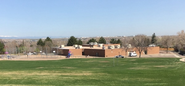
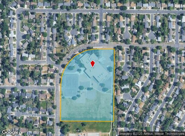
Property Record
9050 Field St, Broomfield, CO 80021
NEARBY LISTINGS FOR SALE OR LEASE
-
-
View all Broomfield listings for sale on LoopNet.com
Property Detail
9050 Field St
Denver-Aurora-Centennial, CO
Kings Mill North
29-224-12-018
SECTION 22 TOWNSHIP 02 RANGE 69 QTR SE SUBDIVISIONCD 413600 SUBDIVISIONNAME KINGS MILL NORTH BLOCK 008 LOT 0050 SIZE: 370260 TRACT VALUE: 8.500
Parkplaygroundpicnicarea
Jefferson
X
Colorado
08059C0201G
50
0
8.50 AC
2024
Northwest Denver
009828
Denver
43,874 SF
DEMOGRAPHICS near 9050 Field St
1 mile
3 mile
5 mile
2024 Total Population
12,209
88,794
268,704
2029 Population
11,969
88,307
272,270
Pop Growth 2024-2029
(1.97%)
(0.55%)
+ 1.33%
Average Age
43
40
40
2024 Total Households
5,232
35,879
106,618
HH Growth 2024-2029
(2.05%)
(0.45%)
+ 1.40%
Median Household Inc
$94,192
$94,471
$85,954
Avg Household Size
2.30
2.40
2.40
2024 Avg HH Vehicles
2.00
2.00
2.00
Median Home Value
$420,169
$476,792
$465,734
Median Year Built
1979
1979
1980
Nearby Places
Map Layers
Map Styles
 Street
 Aerial
Transit
 Traffic
 Biking
Places
Listings with unknown addresses are not visible on the map
- Restaurants
- Banks
- Shops
- Fitness
- Groceries
PUBLIC TRANSPORTATION
COMMUTER RAIL
Drive
Walk
Distance
12 min
5.5 mi
Drive
Walk
Distance
13 min
5.9 mi
AIRPORT
Denver International
Drive
Walk
Distance
Denver International
43 min
30.8 mi
SALE & LEASE HISTORY
LISTING DATE
SALE/LEASE

Jul 25, 2017
For Sale
Nearby Properties
Address
Land Use
TOTAL SIZE
Lot Size
Zoning
Address
Land Use
TOTAL SIZE
Lot Size
Zoning
208,500 SF
8.42 AC
Address
Land Use
TOTAL SIZE
Lot Size
Zoning
431,902 SF
17.63 AC
Address
Land Use
TOTAL SIZE
Lot Size
Zoning
211,191 SF
30.46 AC
Address
Land Use
TOTAL SIZE
Lot Size
Zoning
209,009 SF
22.30 AC
Address
Land Use
TOTAL SIZE
Lot Size
Zoning
212,852 SF
12.82 AC
Address
Land Use
TOTAL SIZE
Lot Size
Zoning
159,724 SF
8.11 AC
Address
Land Use
TOTAL SIZE
Lot Size
Zoning
53,602 SF
2.37 AC
Address
Land Use
TOTAL SIZE
Lot Size
Zoning
674,481 SF
21.06 AC
Address
Land Use
TOTAL SIZE
Lot Size
Zoning
250,701 SF
14.14 AC
Address
Land Use
TOTAL SIZE
Lot Size
Zoning
70,338 SF
2.57 AC
Address
Land Use
TOTAL SIZE
Lot Size
Zoning
166,982 SF
10.06 AC
Address
Land Use
TOTAL SIZE
Lot Size
Zoning
121,639 SF
25.99 AC
Address
Land Use
TOTAL SIZE
Lot Size
Zoning
34,584 SF
13.70 AC
PUD
Address
Land Use
TOTAL SIZE
Lot Size
Zoning
114,230 SF
2.88 AC
Address
Land Use
TOTAL SIZE
Lot Size
Zoning
127,434 SF
7.53 AC
Address
Land Use
TOTAL SIZE
Lot Size
Zoning
133,126 SF
8.21 AC
Address
Land Use
TOTAL SIZE
Lot Size
Zoning
133,573 SF
7.93 AC
PD
Address
Land Use
TOTAL SIZE
Lot Size
Zoning
133,573 SF
8.74 AC
PD
Address
Land Use
TOTAL SIZE
Lot Size
Zoning
141,741 SF
5.58 AC
Address
Land Use
TOTAL SIZE
Lot Size
Zoning
419,774 SF
11.38 AC
PUD
Address
Land Use
TOTAL SIZE
Lot Size
Zoning
310,000 SF
26.51 AC
Address
Land Use
TOTAL SIZE
Lot Size
Zoning
315,637 SF
8.56 AC
Address
Land Use
TOTAL SIZE
Lot Size
Zoning
155,081 SF
7.42 AC
Address
Land Use
TOTAL SIZE
Lot Size
Zoning
133,396 SF
8.02 AC
Address
Land Use
TOTAL SIZE
Lot Size
Zoning
170,218 SF
18.80 AC
PUD
Address
Land Use
TOTAL SIZE
Lot Size
Zoning
275,421 SF
7.79 AC
Address
Land Use
TOTAL SIZE
Lot Size
Zoning
559,786 SF
26.52 AC
Address
Land Use
TOTAL SIZE
Lot Size
Zoning
115,054 SF
21.38 AC
Address
Land Use
TOTAL SIZE
Lot Size
Zoning
307,396 SF
6.68 AC
PUD
Address
Land Use
TOTAL SIZE
Lot Size
Zoning
102,598 SF
7.52 AC
The World's #1 Commercial Real Estate Marketplace
Connect with us
© 2026 CoStar Group
The information above has been obtained from sources believed reliable. While we do not doubt its accuracy we have not verified it and make no guarantee, warranty or representation about it. It is your responsibility to independently confirm its accuracy and completeness. Any projections, opinions, assumptions, or estimates used are for example only and do not represent the current or future performance of the property. The value of this transaction to you depends on tax and other factors which should be evaluated by your tax, financial, and legal advisors. You and your advisors should conduct a careful, independent investigation of the property to determine to your satisfaction the suitability of the property for your needs.