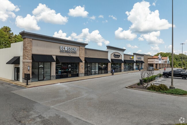
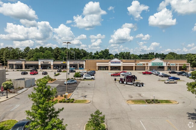
Property Record
9050 Us Highway 64, Arlington, TN 38002

NEARBY LISTINGS FOR SALE OR LEASE
Property Detail
9050 Us Highway 64
L0-159-0-0408
NS HWY 64 COR FLETCHER TRACE NW
Regionalshoppingcenterormallwithanchorstore
Shelby
X
Tennessee
47157C0310G
6.93 AC
2024
Northeast
2025
Memphis
020837
Memphis, TN-MS-AR
74,381 SF
DEMOGRAPHICS near 9050 Us Highway 64
1 Mile
3 Mile
5 Mile
2024 Total Population
7,696
49,022
114,177
2029 Population
7,479
47,553
110,916
Pop Growth 2024-2029
(2.82%)
(3.00%)
(2.86%)
Average Age
38
38
39
2024 Total Households
3,135
18,599
43,437
HH Growth 2024-2029
(2.93%)
(3.08%)
(2.95%)
Median Household Inc
$69,714
$77,694
$78,349
Avg Household Size
2.40
2.60
2.60
2024 Avg HH Vehicles
2.00
2.00
2.00
Median Home Value
$262,830
$250,640
$247,797
Median Year Built
1992
1994
1994
Nearby Places
Map Layers
Map Styles
 Street
 Aerial
- Restaurants
- Banks
- Shops
- Fitness
- Groceries
PUBLIC TRANSPORTATION
AIRPORT
Memphis International
DRIVE
WALK
Distance
Memphis International
32 min
22.1 mi
SALE & LEASE HISTORY
LISTING DATE
SALE/LEASE

Sep 25, 2016
For Lease
Nov 05, 2019
For Lease
May 15, 2017
For Lease
Aug 09, 2017
For Lease
Nearby Properties
Address
Land Use
TOTAL SIZE
Lot Size
Zoning
Address
Land Use
TOTAL SIZE
Lot Size
Zoning
270,045 SF
28.34 AC
CA
Address
Land Use
TOTAL SIZE
Lot Size
Zoning
1,153,892 SF
50.47 AC
I-P
Address
Land Use
TOTAL SIZE
Lot Size
Zoning
207,537 SF
21.73 AC
C-G
Address
Land Use
TOTAL SIZE
Lot Size
Zoning
591,149 SF
45.48 AC
CMU-3
Address
Land Use
TOTAL SIZE
Lot Size
Zoning
338,215 SF
33.08 AC
CA
Address
Land Use
TOTAL SIZE
Lot Size
Zoning
101,701 SF
39.63 AC
M-R
Address
Land Use
TOTAL SIZE
Lot Size
Zoning
498,680 SF
46.61 AC
I-P
Address
Land Use
TOTAL SIZE
Lot Size
Zoning
19,050 SF
24.99 AC
R-M
Address
Land Use
TOTAL SIZE
Lot Size
Zoning
64,002 SF
67.10 AC
RU-2
Address
Land Use
TOTAL SIZE
Lot Size
Zoning
79,341 SF
31.15 AC
RU-3
Address
Land Use
TOTAL SIZE
Lot Size
Zoning
62,852 SF
10.15 AC
RS-12
Address
Land Use
TOTAL SIZE
Lot Size
Zoning
222,468 SF
37.55 AC
C-H
Address
Land Use
TOTAL SIZE
Lot Size
Zoning
56,431 SF
1.24 AC
C-G
Address
Land Use
TOTAL SIZE
Lot Size
Zoning
86,056 SF
24.15 AC
CA
Address
Land Use
TOTAL SIZE
Lot Size
Zoning
32,171 SF
25.06 AC
CA
Address
Land Use
TOTAL SIZE
Lot Size
Zoning
199,320 SF
9.05 AC
CA
Address
Land Use
TOTAL SIZE
Lot Size
Zoning
38,480 SF
24.03 AC
CA
Address
Land Use
TOTAL SIZE
Lot Size
Zoning
94,022 SF
114.02 AC
C-2
Address
Land Use
TOTAL SIZE
Lot Size
Zoning
105,950 SF
21.19 AC
RU-3
Address
Land Use
TOTAL SIZE
Lot Size
Zoning
134,599 SF
6.43 AC
I-P
Address
Land Use
TOTAL SIZE
Lot Size
Zoning
256,617 SF
10.54 AC
I-P
Address
Land Use
TOTAL SIZE
Lot Size
Zoning
86,875 SF
7.09 AC
I-P
Address
Land Use
TOTAL SIZE
Lot Size
Zoning
83,822 SF
25.27 AC
CA
Address
Land Use
TOTAL SIZE
Lot Size
Zoning
146,182 SF
14.45 AC
OG
Address
Land Use
TOTAL SIZE
Lot Size
Zoning
120,863 SF
13.89 AC
CA
Address
Land Use
TOTAL SIZE
Lot Size
Zoning
38,241 SF
3 AC
CMU-3
Address
Land Use
TOTAL SIZE
Lot Size
Zoning
61,430 SF
12.52 AC
RU-3
Address
Land Use
TOTAL SIZE
Lot Size
Zoning
211,953 SF
17.05 AC
C-H
Address
Land Use
TOTAL SIZE
Lot Size
Zoning
73,608 SF
15 AC
CA
Address
Land Use
TOTAL SIZE
Lot Size
Zoning
29,551 SF
1.89 AC
CMU-3
The World's #1 Commercial Real Estate Marketplace
Connect with us
© 2026 CoStar Group
The information above has been obtained from sources believed reliable. While we do not doubt its accuracy we have not verified it and make no guarantee, warranty or representation about it. It is your responsibility to independently confirm its accuracy and completeness. Any projections, opinions, assumptions, or estimates used are for example only and do not represent the current or future performance of the property. The value of this transaction to you depends on tax and other factors which should be evaluated by your tax, financial, and legal advisors. You and your advisors should conduct a careful, independent investigation of the property to determine to your satisfaction the suitability of the property for your needs.