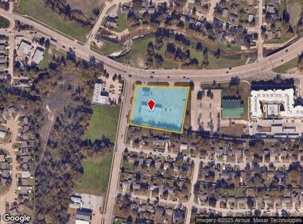
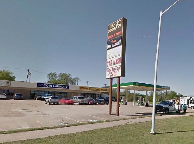
Property Record
906 Highway 66, Garland, TX 75040

NEARBY LISTINGS FOR SALE OR LEASE
Property Detail
906 Highway 66
Dallas-Fort Worth-Arlington, TX
Glynnhill Estates
26242500010300100
GLYNNHILL ESTATES BLK 1 TR 30.1 ACS 2.216 AC INT201500123779 DD05062015 CO-DC 2425000103001 2CG24250001
Stripcommercialcenter
Dallas
X
Texas
48113C0240K
30
2024
2.22 AC
2025
Garland
018203
Dallas/Ft Worth
7,500 SF
DEMOGRAPHICS near 906 Highway 66
1 Mile
3 Mile
5 Mile
2024 Total Population
14,603
115,105
289,091
2029 Population
14,398
113,427
285,690
Pop Growth 2024-2029
(1.40%)
(1.46%)
(1.18%)
Average Age
35
37
37
2024 Total Households
3,954
36,043
96,610
HH Growth 2024-2029
(1.62%)
(1.69%)
(1.39%)
Median Household Inc
$60,868
$67,427
$65,418
Avg Household Size
3.50
3.10
2.90
2024 Avg HH Vehicles
2.00
2.00
2.00
Median Home Value
$171,725
$217,482
$233,863
Median Year Built
1968
1974
1979
Nearby Places
Map Layers
Map Styles
 Street
 Aerial
- Restaurants
- Banks
- Shops
- Fitness
- Groceries
PUBLIC TRANSPORTATION
AIRPORT
Dallas Love Field
DRIVE
WALK
Distance
Dallas Love Field
33 min
21.6 mi
Dallas-Fort Worth International
DRIVE
WALK
Distance
Dallas-Fort Worth International
41 min
30.5 mi
Freight Ports
Port of Shreveport
DRIVE
WALK
Distance
Port of Shreveport
213 min
192.6 mi
Nearby Properties
Address
Land Use
TOTAL SIZE
Lot Size
Zoning
Address
Land Use
TOTAL SIZE
Lot Size
Zoning
181,854 SF
14.51 AC
Z239
Address
Land Use
TOTAL SIZE
Lot Size
Zoning
261,164 SF
32.58 AC
Address
Land Use
TOTAL SIZE
Lot Size
Zoning
107,686 SF
30.09 AC
Z386
Address
Land Use
TOTAL SIZE
Lot Size
Zoning
65,595 SF
19.22 AC
Z239
Address
Land Use
TOTAL SIZE
Lot Size
Zoning
187,440 SF
1.68 AC
Z25
Address
Land Use
TOTAL SIZE
Lot Size
Zoning
77,102 SF
27.47 AC
Z144
Address
Land Use
TOTAL SIZE
Lot Size
Zoning
198,488 SF
10.17 AC
Z239
Address
Land Use
TOTAL SIZE
Lot Size
Zoning
0.12 AC
Z63
Address
Land Use
TOTAL SIZE
Lot Size
Zoning
168,537 SF
2 AC
Address
Land Use
TOTAL SIZE
Lot Size
Zoning
138,865 SF
11.38 AC
Z239
Address
Land Use
TOTAL SIZE
Lot Size
Zoning
139,133 SF
3.34 AC
Z239
Address
Land Use
TOTAL SIZE
Lot Size
Zoning
133,249 SF
9.71 AC
Z239
Address
Land Use
TOTAL SIZE
Lot Size
Zoning
59,546 SF
60.69 AC
Z390
Address
Land Use
TOTAL SIZE
Lot Size
Zoning
65,917 SF
7.99 AC
Z239
Address
Land Use
TOTAL SIZE
Lot Size
Zoning
177,739 SF
11.10 AC
Z390
Address
Land Use
TOTAL SIZE
Lot Size
Zoning
117,036 SF
11.89 AC
Z239
Address
Land Use
TOTAL SIZE
Lot Size
Zoning
145,203 SF
12.86 AC
Z239
Address
Land Use
TOTAL SIZE
Lot Size
Zoning
156,000 SF
2 AC
Address
Land Use
TOTAL SIZE
Lot Size
Zoning
228,800 SF
10.49 AC
Z144
Address
Land Use
TOTAL SIZE
Lot Size
Zoning
119,397 SF
7.41 AC
Z160
Address
Land Use
TOTAL SIZE
Lot Size
Zoning
76,812 SF
9.22 AC
Z144
Address
Land Use
TOTAL SIZE
Lot Size
Zoning
164,220 SF
10.76 AC
Z239
Address
Land Use
TOTAL SIZE
Lot Size
Zoning
226,800 SF
4.98 AC
Z340
Address
Land Use
TOTAL SIZE
Lot Size
Zoning
201,347 SF
14.63 AC
Z109
Address
Land Use
TOTAL SIZE
Lot Size
Zoning
131,960 SF
9.04 AC
Z239
Address
Land Use
TOTAL SIZE
Lot Size
Zoning
278,400 SF
11.78 AC
Z144
Address
Land Use
TOTAL SIZE
Lot Size
Zoning
138,541 SF
3.33 AC
Z25
Address
Land Use
TOTAL SIZE
Lot Size
Zoning
167,236 SF
23.92 AC
Z99
Address
Land Use
TOTAL SIZE
Lot Size
Zoning
297,557 SF
16 AC
Address
Land Use
TOTAL SIZE
Lot Size
Zoning
281,352 SF
12.72 AC
Z144
The World's #1 Commercial Real Estate Marketplace
Connect with us
© 2026 CoStar Group
The information above has been obtained from sources believed reliable. While we do not doubt its accuracy we have not verified it and make no guarantee, warranty or representation about it. It is your responsibility to independently confirm its accuracy and completeness. Any projections, opinions, assumptions, or estimates used are for example only and do not represent the current or future performance of the property. The value of this transaction to you depends on tax and other factors which should be evaluated by your tax, financial, and legal advisors. You and your advisors should conduct a careful, independent investigation of the property to determine to your satisfaction the suitability of the property for your needs.