Property Record
906 N 1464 Rd, Lawrence, KS 66049
NEARBY LISTINGS FOR SALE OR LEASE
-
-
View all Lawrence listings for sale on LoopNet.com
Property Detail
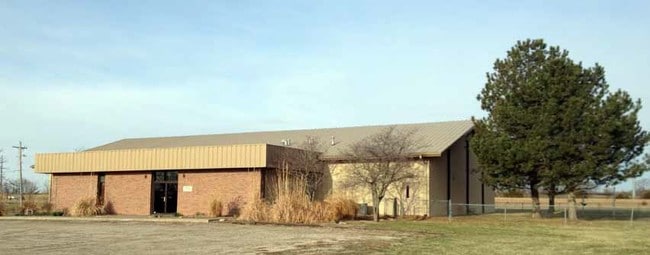
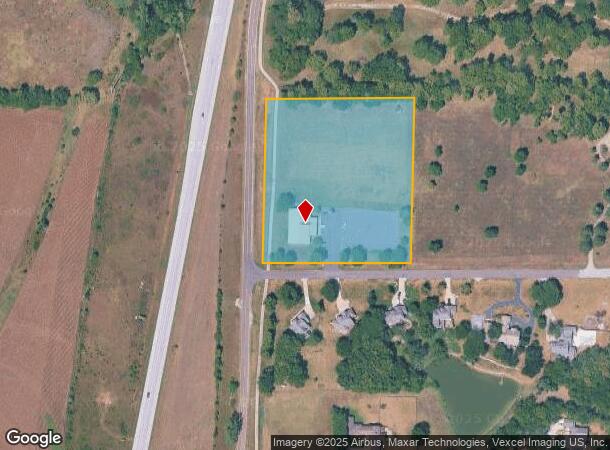
906 N 1464 Rd
Lawrence, KS
Community Bible Church Add
023-113-05-0-20-01-005.00-0
COMMUNITY BIBLE CHURCH ADD LT 1 WW35
Religious
Douglas
X
Kansas
20045C0154D
1
0
4.88 AC
2025
Lawrence
000602
Kansas City
7,000 SF
DEMOGRAPHICS near 906 N 1464 Rd
1 Mile
3 Mile
5 Mile
2024 Total Population
2,322
28,300
72,317
2029 Population
2,386
28,843
73,722
Pop Growth 2024-2029
+ 2.76%
+ 1.92%
+ 1.94%
Average Age
40
38
36
2024 Total Households
930
12,666
30,564
HH Growth 2024-2029
+ 2.80%
+ 2.05%
+ 2.14%
Median Household Inc
$96,940
$67,818
$56,033
Avg Household Size
2.50
2.20
2.20
2024 Avg HH Vehicles
2.00
2.00
2.00
Median Home Value
$403,465
$348,315
$273,701
Median Year Built
2006
2001
1991
Nearby Places
Map Layers
Map Styles
 Street
 Aerial
- Restaurants
- Banks
- Shops
- Fitness
- Groceries
PUBLIC TRANSPORTATION
COMMUTER RAIL
Lawrence Amtrak Station (Southwest Chief - Amtrak)
DRIVE
WALK
Distance
Lawrence Amtrak Station (Southwest Chief - Amtrak)
15 min
7.1 mi
Freight Ports
Tulsa Port Of Catoosa
DRIVE
WALK
Distance
Tulsa Port Of Catoosa
260 min
215.4 mi
Nearby Properties
Address
Land Use
TOTAL SIZE
Lot Size
Zoning
Address
Land Use
TOTAL SIZE
Lot Size
Zoning
243,311 SF
20.07 AC
AG
Address
Land Use
TOTAL SIZE
Lot Size
Zoning
190,168 SF
55.04 AC
C2
Address
Land Use
TOTAL SIZE
Lot Size
Zoning
143,279 SF
36.20 AC
RS1
Address
Land Use
TOTAL SIZE
Lot Size
Zoning
138,043 SF
26.20 AC
AG
Address
Land Use
TOTAL SIZE
Lot Size
Zoning
11,992 SF
118.15 AC
RS1
Address
Land Use
TOTAL SIZE
Lot Size
Zoning
1,034 SF
254.80 AC
AG
Address
Land Use
TOTAL SIZE
Lot Size
Zoning
56,172 SF
14.05 AC
AG
Address
Land Use
TOTAL SIZE
Lot Size
Zoning
92,819 SF
3.10 AC
RO2
Address
Land Use
TOTAL SIZE
Lot Size
Zoning
55,556 SF
24.90 AC
RM1
Address
Land Use
TOTAL SIZE
Lot Size
Zoning
55,275 SF
12.30 AC
AG
Address
Land Use
TOTAL SIZE
Lot Size
Zoning
51,366 SF
15 AC
RS2
Address
Land Use
TOTAL SIZE
Lot Size
Zoning
40,349 SF
5.02 AC
C2
Address
Land Use
TOTAL SIZE
Lot Size
Zoning
24,083 SF
3.60 AC
Address
Land Use
TOTAL SIZE
Lot Size
Zoning
7,050 SF
8.05 AC
RM1
Address
Land Use
TOTAL SIZE
Lot Size
Zoning
21,147 SF
0.49 AC
Address
Land Use
TOTAL SIZE
Lot Size
Zoning
47,666 SF
Address
Land Use
TOTAL SIZE
Lot Size
Zoning
10,000 SF
18.60 AC
AG
Address
Land Use
TOTAL SIZE
Lot Size
Zoning
67,324 SF
5.83 AC
Address
Land Use
TOTAL SIZE
Lot Size
Zoning
11,712 SF
1.34 AC
M1
Address
Land Use
TOTAL SIZE
Lot Size
Zoning
6,516 SF
16.25 AC
Address
Land Use
TOTAL SIZE
Lot Size
Zoning
15,543 SF
9.30 AC
AG
Address
Land Use
TOTAL SIZE
Lot Size
Zoning
33,820 SF
22.06 AC
Address
Land Use
TOTAL SIZE
Lot Size
Zoning
643.10 AC
AG
Address
Land Use
TOTAL SIZE
Lot Size
Zoning
2,496 SF
328.60 AC
AG
Address
Land Use
TOTAL SIZE
Lot Size
Zoning
239,496 SF
8.21 AC
Address
Land Use
TOTAL SIZE
Lot Size
Zoning
4,384 SF
57 AC
Address
Land Use
TOTAL SIZE
Lot Size
Zoning
85,284 SF
16.88 AC
PRD2
Address
Land Use
TOTAL SIZE
Lot Size
Zoning
26,688 SF
14.34 AC
AG
Address
Land Use
TOTAL SIZE
Lot Size
Zoning
31,848 SF
3.12 AC
RS2
Address
Land Use
TOTAL SIZE
Lot Size
Zoning
16,792 SF
29.57 AC
AG
The World's #1 Commercial Real Estate Marketplace
Connect with us
© 2025 CoStar Group
The information above has been obtained from sources believed reliable. While we do not doubt its accuracy we have not verified it and make no guarantee, warranty or representation about it. It is your responsibility to independently confirm its accuracy and completeness. Any projections, opinions, assumptions, or estimates used are for example only and do not represent the current or future performance of the property. The value of this transaction to you depends on tax and other factors which should be evaluated by your tax, financial, and legal advisors. You and your advisors should conduct a careful, independent investigation of the property to determine to your satisfaction the suitability of the property for your needs.