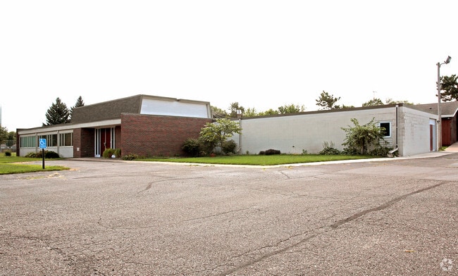
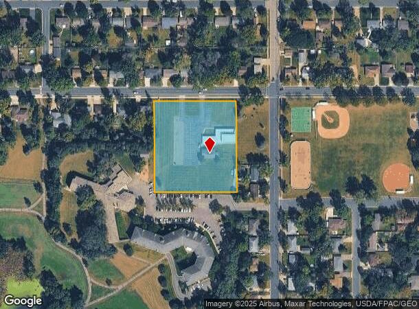
Property Record
907 15Th St W, Hastings, MN 55033
NEARBY LISTINGS FOR SALE OR LEASE
-
-
View all Hastings listings for sale on LoopNet.com
Property Detail
907 15Th St W
Minneapolis-St. Paul-Bloomington, MN-WI
Auditors Subdivision No 11
19-03900-01-030
AUDITORS SUBDIVISION NO 11 1 E 333 FT OF N 400 FT OF LOT 1 & N 200 FT OF W 7 FT THEREOF
Religious
Dakota
X
Minnesota
27037C0276F
1
2024
2.81 AC
2024
Dakota County Outlying
061111
Minneapolis/St Paul
8,088 SF
DEMOGRAPHICS near 907 15Th St W
1 Mile
3 Mile
5 Mile
2024 Total Population
9,990
22,968
31,432
2029 Population
10,162
23,465
32,264
Pop Growth 2024-2029
+ 1.72%
+ 2.16%
+ 2.65%
Average Age
42
42
42
2024 Total Households
4,324
9,409
12,664
HH Growth 2024-2029
+ 1.69%
+ 2.14%
+ 2.61%
Median Household Inc
$79,721
$84,797
$86,655
Avg Household Size
2.30
2.40
2.40
2024 Avg HH Vehicles
2.00
2.00
2.00
Median Home Value
$262,636
$281,537
$287,941
Median Year Built
1971
1984
1984
Nearby Places
Map Layers
Map Styles
 Street
 Aerial
- Restaurants
- Banks
- Shops
- Fitness
- Groceries
PUBLIC TRANSPORTATION
AIRPORT
Minneapolis-St Paul International/Wold-Chamberlain
DRIVE
WALK
Distance
Minneapolis-St Paul International/Wold-Chamberlain
34 min
25.1 mi
Freight Ports
Port Milwaukee
DRIVE
WALK
Distance
Port Milwaukee
370 min
333.3 mi
Nearby Properties
Address
Land Use
TOTAL SIZE
Lot Size
Zoning
Address
Land Use
TOTAL SIZE
Lot Size
Zoning
983,000 SF
41.68 AC
Address
Land Use
TOTAL SIZE
Lot Size
Zoning
427,392 SF
54.06 AC
Address
Land Use
TOTAL SIZE
Lot Size
Zoning
177,117 SF
9.08 AC
Address
Land Use
TOTAL SIZE
Lot Size
Zoning
109,735 SF
1.12 AC
Address
Land Use
TOTAL SIZE
Lot Size
Zoning
113,559 SF
6.29 AC
Address
Land Use
TOTAL SIZE
Lot Size
Zoning
115,394 SF
4.74 AC
Address
Land Use
TOTAL SIZE
Lot Size
Zoning
115,250 SF
1.84 AC
Address
Land Use
TOTAL SIZE
Lot Size
Zoning
101,400 SF
3.10 AC
Address
Land Use
TOTAL SIZE
Lot Size
Zoning
135,563 SF
5.86 AC
Address
Land Use
TOTAL SIZE
Lot Size
Zoning
231,675 SF
92.69 AC
Address
Land Use
TOTAL SIZE
Lot Size
Zoning
94,745 SF
8.91 AC
Address
Land Use
TOTAL SIZE
Lot Size
Zoning
231,725 SF
21.06 AC
Address
Land Use
TOTAL SIZE
Lot Size
Zoning
101,769 SF
5.48 AC
Address
Land Use
TOTAL SIZE
Lot Size
Zoning
84,868 SF
5.85 AC
Address
Land Use
TOTAL SIZE
Lot Size
Zoning
117,813 SF
5.49 AC
Address
Land Use
TOTAL SIZE
Lot Size
Zoning
49,205 SF
5.54 AC
Address
Land Use
TOTAL SIZE
Lot Size
Zoning
88,072 SF
18.46 AC
Address
Land Use
TOTAL SIZE
Lot Size
Zoning
49,091 SF
1.27 AC
Address
Land Use
TOTAL SIZE
Lot Size
Zoning
4.69 AC
Address
Land Use
TOTAL SIZE
Lot Size
Zoning
58,296 SF
2.87 AC
Address
Land Use
TOTAL SIZE
Lot Size
Zoning
3.79 AC
Address
Land Use
TOTAL SIZE
Lot Size
Zoning
103,134 SF
4.52 AC
Address
Land Use
TOTAL SIZE
Lot Size
Zoning
74,700 SF
12.15 AC
Address
Land Use
TOTAL SIZE
Lot Size
Zoning
139,140 SF
3.99 AC
Address
Land Use
TOTAL SIZE
Lot Size
Zoning
1.35 AC
Address
Land Use
TOTAL SIZE
Lot Size
Zoning
28,112 SF
146.03 AC
Address
Land Use
TOTAL SIZE
Lot Size
Zoning
125,958 SF
11.06 AC
Address
Land Use
TOTAL SIZE
Lot Size
Zoning
187,654 SF
2.34 AC
Address
Land Use
TOTAL SIZE
Lot Size
Zoning
47,963 SF
2.59 AC
Address
Land Use
TOTAL SIZE
Lot Size
Zoning
48,883 SF
5.65 AC
The World's #1 Commercial Real Estate Marketplace
Connect with us
© 2025 CoStar Group
The information above has been obtained from sources believed reliable. While we do not doubt its accuracy we have not verified it and make no guarantee, warranty or representation about it. It is your responsibility to independently confirm its accuracy and completeness. Any projections, opinions, assumptions, or estimates used are for example only and do not represent the current or future performance of the property. The value of this transaction to you depends on tax and other factors which should be evaluated by your tax, financial, and legal advisors. You and your advisors should conduct a careful, independent investigation of the property to determine to your satisfaction the suitability of the property for your needs.