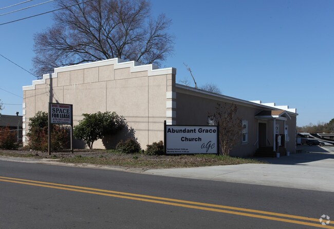
Property Record
907 Jernigan St, Perry, GA 31069

Save to a Folder
{{folder.Name}}
{{folder.ListingIds.length}} Properties
{{folder.ListingIds.length}} Property
Create a New Folder
Property Detail
907 Jernigan St
0P0040003000
PARCEL PM 1.222 ACRES LL 49 10TH LD
Officebuilding
HOUSTON
M2
Georgia
B and X Area of moderate flood hazard, usually the area between the limits of the 100-year and 500-year floods.
49
2025
1.22 AC
2025
Perry/Warner Robins
021205
Other Market Areas
3,984 SF
Warner Robins, GA
NEARBY LISTINGS FOR SALE OR LEASE
-
-
View all Perry listings for lease on LoopNet.com
DEMOGRAPHICS near 907 Jernigan St
1 mile
3 mile
5 mile
2025 Total Population
4,458
17,142
24,817
2030 Population
4,752
18,272
26,460
Pop Growth 2025-2030
+ 6.59%
+ 6.59%
+ 6.62%
Average Age
39
40
40
2025 Total Households
1,706
6,763
9,564
HH Growth 2025-2030
+ 6.80%
+ 6.76%
+ 6.76%
Median Household Inc
$47,177
$67,469
$74,251
Avg Household Size
2.40
2.40
2.50
2025 Avg HH Vehicles
2.00
2.00
2.00
Median Home Value
$144,268
$214,669
$229,074
Median Year Built
1973
1990
1996
Nearby Places
Map Layers
Map Styles
 Street
 Aerial
Layers
 Traffic
 Biking
Places
Listings with unknown addresses are not visible on the map
- Restaurants
- Banks
- Shops
- Fitness
- Groceries
SALE & LEASE HISTORY
LISTING DATE
SALE/LEASE

Jan 20, 2017
For Lease
Nearby Properties
Address
Land Use
TOTAL SIZE
Lot Size
Zoning
Address
Land Use
TOTAL SIZE
Lot Size
Zoning
68,186 SF
559.30 AC
GU
Address
Land Use
TOTAL SIZE
Lot Size
Zoning
147,496 SF
66.05 AC
GU
Address
Land Use
TOTAL SIZE
Lot Size
Zoning
525,957 SF
32.75 AC
M2
Address
Land Use
TOTAL SIZE
Lot Size
Zoning
158,407 SF
218.84 AC
M2
Address
Land Use
TOTAL SIZE
Lot Size
Zoning
262,500 SF
20 AC
GU
Address
Land Use
TOTAL SIZE
Lot Size
Zoning
54,262 SF
38.29 AC
M1
Address
Land Use
TOTAL SIZE
Lot Size
Zoning
151,845 SF
17.55 AC
C2
Address
Land Use
TOTAL SIZE
Lot Size
Zoning
65,040 SF
35.91 AC
M2
Address
Land Use
TOTAL SIZE
Lot Size
Zoning
2,303 SF
24.71 AC
RM-2
Address
Land Use
TOTAL SIZE
Lot Size
Zoning
2,616 SF
16.65 AC
RM-2
Address
Land Use
TOTAL SIZE
Lot Size
Zoning
2,568 SF
10.30 AC
RM-2
Address
Land Use
TOTAL SIZE
Lot Size
Zoning
49,947 SF
4.03 AC
C2
Address
Land Use
TOTAL SIZE
Lot Size
Zoning
59,290 SF
12.29 AC
C2
Address
Land Use
TOTAL SIZE
Lot Size
Zoning
439.32 AC
M2
Address
Land Use
TOTAL SIZE
Lot Size
Zoning
19,125 SF
27.94 AC
R1
Address
Land Use
TOTAL SIZE
Lot Size
Zoning
158,300 SF
30 AC
GU
Address
Land Use
TOTAL SIZE
Lot Size
Zoning
52,336 SF
3.07 AC
C1
Address
Land Use
TOTAL SIZE
Lot Size
Zoning
54,120 SF
8.18 AC
C1
Address
Land Use
TOTAL SIZE
Lot Size
Zoning
54,120 SF
8.18 AC
C1
Address
Land Use
TOTAL SIZE
Lot Size
Zoning
44,292 SF
9.70 AC
FBR
Address
Land Use
TOTAL SIZE
Lot Size
Zoning
49,331 SF
5.56 AC
C2
Address
Land Use
TOTAL SIZE
Lot Size
Zoning
255.39 AC
GU/M1
Address
Land Use
TOTAL SIZE
Lot Size
Zoning
78,800 SF
7.93 AC
C2
Address
Land Use
TOTAL SIZE
Lot Size
Zoning
98,871 SF
8.09 AC
C2
Address
Land Use
TOTAL SIZE
Lot Size
Zoning
19,810 SF
79.64 AC
GU
Address
Land Use
TOTAL SIZE
Lot Size
Zoning
226.03 AC
GU
Address
Land Use
TOTAL SIZE
Lot Size
Zoning
134,145 SF
3.08 AC
M2
Address
Land Use
TOTAL SIZE
Lot Size
Zoning
41,985 SF
1.65 AC
C1/C2
Address
Land Use
TOTAL SIZE
Lot Size
Zoning
51,780 SF
2.50 AC
C1
Address
Land Use
TOTAL SIZE
Lot Size
Zoning
78,010 SF
20 AC
C2
The World's #1 Commercial Real Estate Marketplace
Connect with us
© 2026 CoStar Group
The information above has been obtained from sources believed reliable. While we do not doubt its accuracy we have not verified it and make no guarantee, warranty or representation about it. It is your responsibility to independently confirm its accuracy and completeness. Any projections, opinions, assumptions, or estimates used are for example only and do not represent the current or future performance of the property. The value of this transaction to you depends on tax and other factors which should be evaluated by your tax, financial, and legal advisors. You and your advisors should conduct a careful, independent investigation of the property to determine to your satisfaction the suitability of the property for your needs.