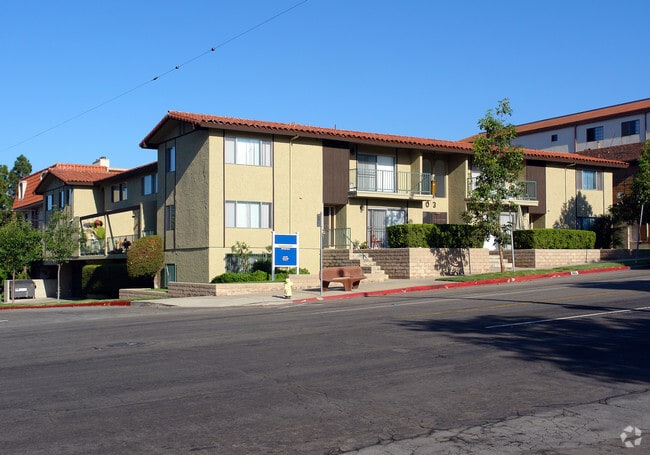
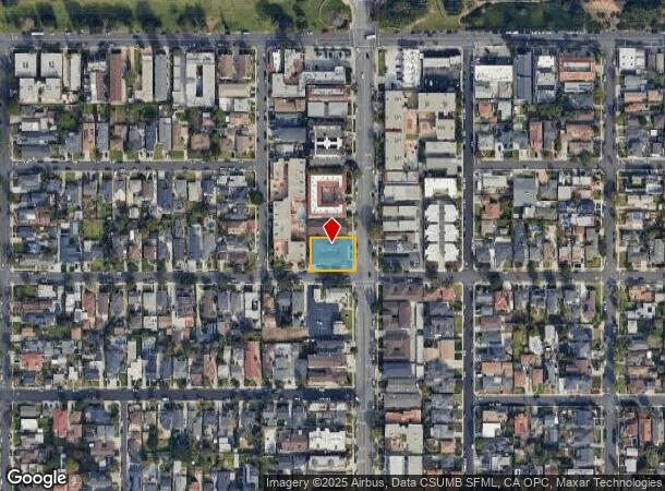
Property Record
907 Main St, El Segundo, CA 90245


NEARBY LISTINGS FOR SALE OR LEASE
Property Detail
907 Main St
Los Angeles-Long Beach-Glendale, CA
Tract No 3690
4132-018-080
TR=3690 LOTS 11 AND 12
Multifamilydwelling
Los Angeles
X
California
06037C1766G
11,12
2024
0.30 AC
2025
El Segundo
620002
Los Angeles
12,076 SF
DEMOGRAPHICS near 907 Main St
1 mile
3 mile
5 mile
2024 Total Population
14,667
84,537
446,903
2029 Population
14,212
82,266
434,916
Pop Growth 2024-2029
(3.10%)
(2.69%)
(2.68%)
Average Age
40
41
39
2024 Total Households
6,087
35,117
175,176
HH Growth 2024-2029
(3.38%)
(2.88%)
(2.80%)
Median Household Inc
$127,328
$129,666
$98,443
Avg Household Size
2.40
2.30
2.50
2024 Avg HH Vehicles
2.00
2.00
2.00
Median Home Value
$1,119,689
$1,089,149
$1,035,591
Median Year Built
1960
1966
1969
Nearby Places
Map Layers
Map Styles
 Street
 Aerial
Transit
 Traffic
 Biking
Places
Listings with unknown addresses are not visible on the map
- Restaurants
- Banks
- Shops
- Fitness
- Groceries
PUBLIC TRANSPORTATION
AIRPORT
Los Angeles International
Drive
Walk
Distance
Los Angeles International
7 min
3.3 mi
Long Beach (Daugherty Field)
Drive
Walk
Distance
Long Beach (Daugherty Field)
27 min
19.5 mi
Bob Hope
Drive
Walk
Distance
Bob Hope
41 min
28.1 mi
Nearby Properties
Address
Land Use
TOTAL SIZE
Lot Size
Zoning
Address
Land Use
TOTAL SIZE
Lot Size
Zoning
1,807,845 SF
7.28 AC
ESC3
Address
Land Use
TOTAL SIZE
Lot Size
Zoning
584,746 SF
20.38 AC
MNIP
Address
Land Use
TOTAL SIZE
Lot Size
Zoning
131,967 SF
94.08 AC
LAR4
Address
Land Use
TOTAL SIZE
Lot Size
Zoning
1,315,931 SF
3.36 AC
ESC3
Address
Land Use
TOTAL SIZE
Lot Size
Zoning
565,264 SF
5.95 AC
Address
Land Use
TOTAL SIZE
Lot Size
Zoning
337,106 SF
9.56 AC
ESCM*
Address
Land Use
TOTAL SIZE
Lot Size
Zoning
522,511 SF
4.91 AC
LARAS4
Address
Land Use
TOTAL SIZE
Lot Size
Zoning
329,810 SF
2.21 AC
LAC2
Address
Land Use
TOTAL SIZE
Lot Size
Zoning
944,791 SF
22.53 AC
ESCM*
Address
Land Use
TOTAL SIZE
Lot Size
Zoning
421,934 SF
8.24 AC
ESCM
Address
Land Use
TOTAL SIZE
Lot Size
Zoning
459,058 SF
8.84 AC
ESC3*
Address
Land Use
TOTAL SIZE
Lot Size
Zoning
632,476 SF
10.56 AC
LAC2
Address
Land Use
TOTAL SIZE
Lot Size
Zoning
784,680 SF
18.28 AC
LAM1
Address
Land Use
TOTAL SIZE
Lot Size
Zoning
284,937 SF
3 AC
LARAS4
Address
Land Use
TOTAL SIZE
Lot Size
Zoning
652,774 SF
3.60 AC
LAC2
Address
Land Use
TOTAL SIZE
Lot Size
Zoning
553,161 SF
21.61 AC
ESM2*
Address
Land Use
TOTAL SIZE
Lot Size
Zoning
418,131 SF
3.03 AC
LCC1
Address
Land Use
TOTAL SIZE
Lot Size
Zoning
793,455 SF
31.88 AC
ESM2*
Address
Land Use
TOTAL SIZE
Lot Size
Zoning
1,410,144 SF
6.35 AC
ESM2*
Address
Land Use
TOTAL SIZE
Lot Size
Zoning
189,244 SF
3.64 AC
ESCM*
Address
Land Use
TOTAL SIZE
Lot Size
Zoning
347,674 SF
5.65 AC
LAR3
Address
Land Use
TOTAL SIZE
Lot Size
Zoning
859,786 SF
4.82 AC
LAC2
Address
Land Use
TOTAL SIZE
Lot Size
Zoning
319,589 SF
5.13 AC
MNPD
Address
Land Use
TOTAL SIZE
Lot Size
Zoning
876,121 SF
9.03 AC
ESC3
Address
Land Use
TOTAL SIZE
Lot Size
Zoning
1,972,924 SF
ESCM*
Address
Land Use
TOTAL SIZE
Lot Size
Zoning
801,040 SF
5.69 AC
LAC2
Address
Land Use
TOTAL SIZE
Lot Size
Zoning
448,818 SF
2.69 AC
ESC3*
Address
Land Use
TOTAL SIZE
Lot Size
Zoning
120,484 SF
11.63 AC
ESM2*
Address
Land Use
TOTAL SIZE
Lot Size
Zoning
307,559 SF
5.96 AC
ESC3
The World's #1 Commercial Real Estate Marketplace
Connect with us
© 2026 CoStar Group
The information above has been obtained from sources believed reliable. While we do not doubt its accuracy we have not verified it and make no guarantee, warranty or representation about it. It is your responsibility to independently confirm its accuracy and completeness. Any projections, opinions, assumptions, or estimates used are for example only and do not represent the current or future performance of the property. The value of this transaction to you depends on tax and other factors which should be evaluated by your tax, financial, and legal advisors. You and your advisors should conduct a careful, independent investigation of the property to determine to your satisfaction the suitability of the property for your needs.