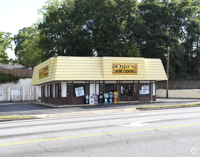
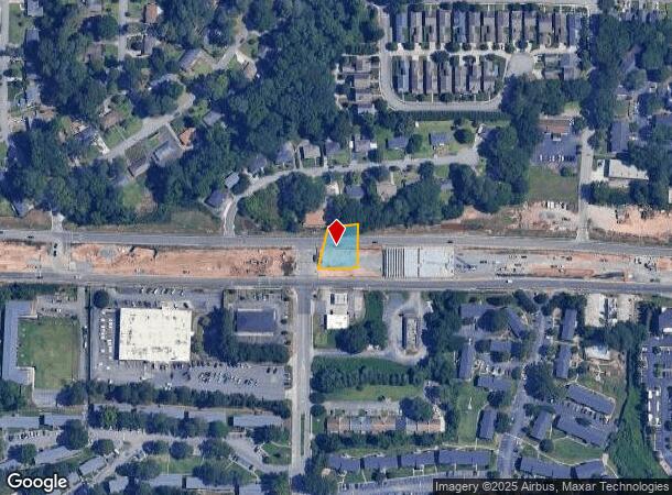
Property Record
907 Windy Hill Rd Se, Smyrna, GA 30080

NEARBY LISTINGS FOR SALE OR LEASE
Property Detail
907 Windy Hill Rd Se
Governmentalpublicusegeneral
Cobb
X
Georgia
13067C0119H
0.25 AC
0
Cumberland/Galleria
2025
Atlanta
031101
Atlanta-Sandy Springs-Roswell, GA
1,870 SF
17-0446-0-019-0
DEMOGRAPHICS near 907 Windy Hill Rd Se
1 Mile
3 Mile
5 Mile
2024 Total Population
11,419
100,154
256,132
2029 Population
11,670
102,487
261,459
Pop Growth 2024-2029
+ 2.20%
+ 2.33%
+ 2.08%
Average Age
35
36
37
2024 Total Households
4,528
41,121
109,821
HH Growth 2024-2029
+ 2.21%
+ 2.27%
+ 2.04%
Median Household Inc
$66,595
$65,183
$76,555
Avg Household Size
2.40
2.40
2.30
2024 Avg HH Vehicles
2.00
2.00
2.00
Median Home Value
$324,687
$316,276
$348,301
Median Year Built
1973
1983
1986
Nearby Places
Map Layers
Map Styles
 Street
 Aerial
- Restaurants
- Banks
- Shops
- Fitness
- Groceries
PUBLIC TRANSPORTATION
AIRPORT
Hartsfield - Jackson Atlanta International
DRIVE
WALK
Distance
Hartsfield - Jackson Atlanta International
37 min
25.2 mi
Freight Ports
Georgia Ports - Savannah
DRIVE
WALK
Distance
Georgia Ports - Savannah
300 min
264.5 mi
Nearby Properties
Address
Land Use
TOTAL SIZE
Lot Size
Zoning
Address
Land Use
TOTAL SIZE
Lot Size
Zoning
553,125 SF
42.07 AC
PRD MF
Address
Land Use
TOTAL SIZE
Lot Size
Zoning
237,743 SF
10.32 AC
RRC
Address
Land Use
TOTAL SIZE
Lot Size
Zoning
389,428 SF
22.50 AC
RM12
Address
Land Use
TOTAL SIZE
Lot Size
Zoning
437,793 SF
41.12 AC
RM-16
Address
Land Use
TOTAL SIZE
Lot Size
Zoning
424,402 SF
34.46 AC
RM-12
Address
Land Use
TOTAL SIZE
Lot Size
Zoning
504,744 SF
44.36 AC
RM-12
Address
Land Use
TOTAL SIZE
Lot Size
Zoning
85,489 SF
6.20 AC
PRD MF
Address
Land Use
TOTAL SIZE
Lot Size
Zoning
357,031 SF
10.69 AC
MU
Address
Land Use
TOTAL SIZE
Lot Size
Zoning
285,395 SF
26.58 AC
RM-12
Address
Land Use
TOTAL SIZE
Lot Size
Zoning
452,366 SF
27.27 AC
PRD MF
Address
Land Use
TOTAL SIZE
Lot Size
Zoning
374,698 SF
30.72 AC
RM-12
Address
Land Use
TOTAL SIZE
Lot Size
Zoning
477,544 SF
4.61 AC
MU
Address
Land Use
TOTAL SIZE
Lot Size
Zoning
264,878 SF
28.71 AC
RM-16
Address
Land Use
TOTAL SIZE
Lot Size
Zoning
385,088 SF
33.31 AC
RM-12
Address
Land Use
TOTAL SIZE
Lot Size
Zoning
313,882 SF
22.33 AC
RM-12
Address
Land Use
TOTAL SIZE
Lot Size
Zoning
376,618 SF
22.82 AC
RM-12
Address
Land Use
TOTAL SIZE
Lot Size
Zoning
227,558 SF
27.80 AC
RM-12
Address
Land Use
TOTAL SIZE
Lot Size
Zoning
428,305 SF
30.88 AC
RM-16
Address
Land Use
TOTAL SIZE
Lot Size
Zoning
488,748 SF
32.28 AC
RM-12
Address
Land Use
TOTAL SIZE
Lot Size
Zoning
230,032 SF
19.77 AC
RM-16
Address
Land Use
TOTAL SIZE
Lot Size
Zoning
215,194 SF
15 AC
RM-16
Address
Land Use
TOTAL SIZE
Lot Size
Zoning
545,301 SF
38.70 AC
RM-12
Address
Land Use
TOTAL SIZE
Lot Size
Zoning
267,021 SF
13.72 AC
RM-16
Address
Land Use
TOTAL SIZE
Lot Size
Zoning
285,190 SF
25.16 AC
RM-12
Address
Land Use
TOTAL SIZE
Lot Size
Zoning
698,904 SF
36.69 AC
HI
Address
Land Use
TOTAL SIZE
Lot Size
Zoning
290,588 SF
21.54 AC
RM-16
Address
Land Use
TOTAL SIZE
Lot Size
Zoning
8,980 SF
51.17 AC
Address
Land Use
TOTAL SIZE
Lot Size
Zoning
347,671 SF
23.59 AC
RM-12
Address
Land Use
TOTAL SIZE
Lot Size
Zoning
237,498 SF
29.95 AC
RM-12
Address
Land Use
TOTAL SIZE
Lot Size
Zoning
304,516 SF
25 AC
RM-12
The World's #1 Commercial Real Estate Marketplace
Connect with us
© 2025 CoStar Group
The information above has been obtained from sources believed reliable. While we do not doubt its accuracy we have not verified it and make no guarantee, warranty or representation about it. It is your responsibility to independently confirm its accuracy and completeness. Any projections, opinions, assumptions, or estimates used are for example only and do not represent the current or future performance of the property. The value of this transaction to you depends on tax and other factors which should be evaluated by your tax, financial, and legal advisors. You and your advisors should conduct a careful, independent investigation of the property to determine to your satisfaction the suitability of the property for your needs.