Property Record
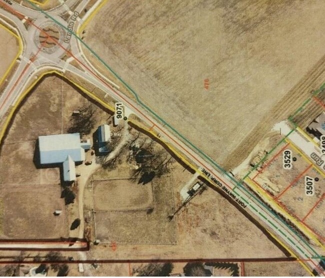
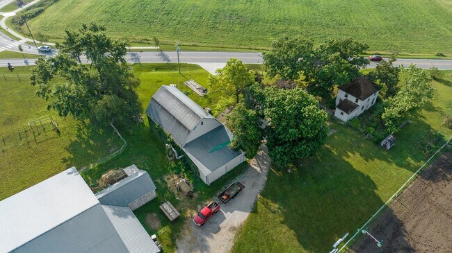
9071 Maysville Rd, Fort Wayne, IN 46815

NEARBY LISTINGS FOR SALE OR LEASE
Property Detail
9071 Maysville Rd
02-08-26-426-005.000-072
Maysville
Livestock
9.115 A TR S OF TRIER RD & N OF MAYSVILLE RD PT OF E 61.35 A SE1/4 SEC 26 EX .20 AC TR ON W
X
Allen
18003C0307G
Indiana
2023
8.92 AC
2024
North Fort Wayne
010809
Fort Wayne
2,060 SF
Fort Wayne, IN
DEMOGRAPHICS near 9071 Maysville Rd
1 Mile
3 Mile
5 Mile
2024 Total Population
5,097
42,928
97,755
2029 Population
5,271
44,327
101,213
Pop Growth 2024-2029
+ 3.41%
+ 3.26%
+ 3.54%
Average Age
42
40
39
2024 Total Households
2,048
16,930
39,647
HH Growth 2024-2029
+ 3.42%
+ 3.33%
+ 3.61%
Median Household Inc
$79,419
$71,790
$62,897
Avg Household Size
2.40
2.50
2.40
2024 Avg HH Vehicles
2.00
2.00
2.00
Median Home Value
$171,268
$168,889
$161,176
Median Year Built
1980
1978
1975
Nearby Places
Map Layers
Map Styles
 Street
 Aerial
- Restaurants
- Banks
- Shops
- Fitness
- Groceries
PUBLIC TRANSPORTATION
AIRPORT
Fort Wayne International
DRIVE
WALK
Distance
Fort Wayne International
33 min
18.0 mi
SALE & LEASE HISTORY
LISTING DATE
SALE/LEASE

Sep 01, 2023
For Sale
Feb 25, 2022
For Sale
Nearby Properties
Address
Land Use
TOTAL SIZE
Lot Size
Zoning
Address
Land Use
TOTAL SIZE
Lot Size
Zoning
23,326 SF
15.27 AC
Address
Land Use
TOTAL SIZE
Lot Size
Zoning
298,087 SF
24.54 AC
Address
Land Use
TOTAL SIZE
Lot Size
Zoning
215,768 SF
23.56 AC
Address
Land Use
TOTAL SIZE
Lot Size
Zoning
144,297 SF
19.16 AC
Address
Land Use
TOTAL SIZE
Lot Size
Zoning
25,272 SF
2.58 AC
Address
Land Use
TOTAL SIZE
Lot Size
Zoning
206,618 SF
21.20 AC
Address
Land Use
TOTAL SIZE
Lot Size
Zoning
210,230 SF
35.30 AC
Address
Land Use
TOTAL SIZE
Lot Size
Zoning
58,913 SF
22.64 AC
Address
Land Use
TOTAL SIZE
Lot Size
Zoning
169,740 SF
30.62 AC
Address
Land Use
TOTAL SIZE
Lot Size
Zoning
154,746 SF
8.75 AC
Address
Land Use
TOTAL SIZE
Lot Size
Zoning
72,240 SF
9.41 AC
Address
Land Use
TOTAL SIZE
Lot Size
Zoning
19,872 SF
13.38 AC
Address
Land Use
TOTAL SIZE
Lot Size
Zoning
126,495 SF
9.28 AC
Address
Land Use
TOTAL SIZE
Lot Size
Zoning
70,312 SF
25.22 AC
Address
Land Use
TOTAL SIZE
Lot Size
Zoning
145,580 SF
8.15 AC
Address
Land Use
TOTAL SIZE
Lot Size
Zoning
94,015 SF
9.45 AC
Address
Land Use
TOTAL SIZE
Lot Size
Zoning
24,612 SF
5.83 AC
Address
Land Use
TOTAL SIZE
Lot Size
Zoning
79,707 SF
11.53 AC
Address
Land Use
TOTAL SIZE
Lot Size
Zoning
119,799 SF
16.42 AC
Address
Land Use
TOTAL SIZE
Lot Size
Zoning
105,868 SF
13.42 AC
Address
Land Use
TOTAL SIZE
Lot Size
Zoning
142,983 SF
10.02 AC
Address
Land Use
TOTAL SIZE
Lot Size
Zoning
121,567 SF
7.37 AC
Address
Land Use
TOTAL SIZE
Lot Size
Zoning
106,164 SF
10.34 AC
Address
Land Use
TOTAL SIZE
Lot Size
Zoning
118,956 SF
36.27 AC
Address
Land Use
TOTAL SIZE
Lot Size
Zoning
90,318 SF
23.70 AC
Address
Land Use
TOTAL SIZE
Lot Size
Zoning
96,315 SF
8.33 AC
Address
Land Use
TOTAL SIZE
Lot Size
Zoning
125,419 SF
10.77 AC
Address
Land Use
TOTAL SIZE
Lot Size
Zoning
57,932 SF
11.71 AC
Address
Land Use
TOTAL SIZE
Lot Size
Zoning
16,250 SF
2.02 AC
Address
Land Use
TOTAL SIZE
Lot Size
Zoning
123,852 SF
9.40 AC
The World's #1 Commercial Real Estate Marketplace
Connect with us
© 2025 CoStar Group
The information above has been obtained from sources believed reliable. While we do not doubt its accuracy we have not verified it and make no guarantee, warranty or representation about it. It is your responsibility to independently confirm its accuracy and completeness. Any projections, opinions, assumptions, or estimates used are for example only and do not represent the current or future performance of the property. The value of this transaction to you depends on tax and other factors which should be evaluated by your tax, financial, and legal advisors. You and your advisors should conduct a careful, independent investigation of the property to determine to your satisfaction the suitability of the property for your needs.