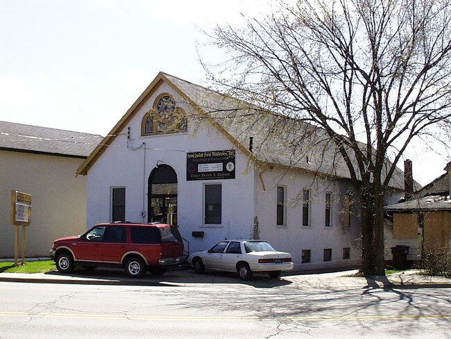
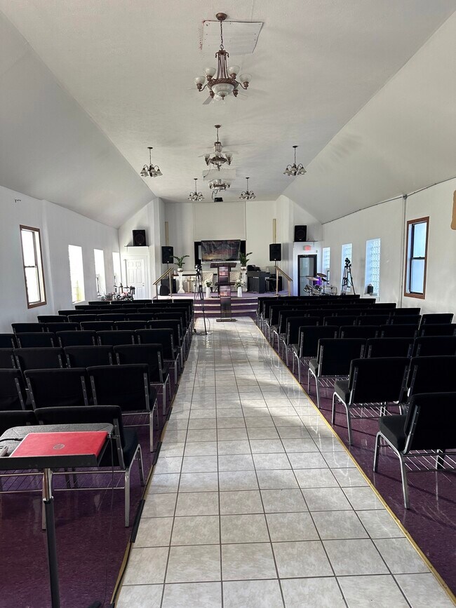
Property Record
908 Gull Rd, Kalamazoo, MI 49048

Property Detail
908 Gull Rd
06-14-120-002
12508 M AMPERSEES PLAT UNION ADDITION SLY 10FT OF LOT 3. ALSO, ELY 33FT OF LOT 8.
Commercialnec
Kalamazoo
RMU
Michigan
AE The base floodplain where base flood elevations are provided. AE Zones are now used on new format FIRMs instead of A1-A30 Zones.
3,8
2024
0.13 AC
2025
Central Kalamazoo
000100
West Michigan
2,700 SF
Kalamazoo-Portage, MI
NEARBY LISTINGS FOR SALE OR LEASE
-
-
View all Kalamazoo listings for sale on LoopNet.com
DEMOGRAPHICS near 908 Gull Rd
1 mile
3 mile
5 mile
2025 Total Population
6,537
71,976
139,791
2030 Population
6,644
73,597
143,093
Pop Growth 2025-2030
+ 1.64%
+ 2.25%
+ 2.36%
Average Age
36
36
36
2025 Total Households
2,416
28,570
58,783
HH Growth 2025-2030
+ 1.78%
+ 2.65%
+ 2.52%
Median Household Inc
$46,020
$52,843
$55,031
Avg Household Size
2.50
2.20
2.20
2025 Avg HH Vehicles
1.00
2.00
2.00
Median Home Value
$110,325
$159,010
$187,207
Median Year Built
1948
1955
1969
Nearby Places
Map Layers
Map Styles
 Street
 Aerial
Layers
 Traffic
 Biking
Places
Listings with unknown addresses are not visible on the map
- Restaurants
- Banks
- Shops
- Fitness
- Groceries
PUBLIC TRANSPORTATION
COMMUTER RAIL
Kalamazoo (Blue Water - Amtrak, Wolverine - Amtrak)
Drive
Walk
Distance
Kalamazoo (Blue Water - Amtrak, Wolverine - Amtrak)
2 min
18 min
0.9 mi
AIRPORT
Kalamazoo/Battle Creek International
Drive
Walk
Distance
Kalamazoo/Battle Creek International
16 min
7.1 mi
Freight Ports
Port of Toledo
Drive
Walk
Distance
Port of Toledo
175 min
144.6 mi
SALE & LEASE HISTORY
LISTING DATE
SALE/LEASE

Nov 15, 2022
For Sale
Nearby Properties
Address
Land Use
TOTAL SIZE
Lot Size
Zoning
Address
Land Use
TOTAL SIZE
Lot Size
Zoning
632,218 SF
10.84 AC
M-1
Address
Land Use
TOTAL SIZE
Lot Size
Zoning
329,276 SF
43.86 AC
RM-1
Address
Land Use
TOTAL SIZE
Lot Size
Zoning
429,500 SF
2 AC
CCBD
Address
Land Use
TOTAL SIZE
Lot Size
Zoning
877,422 SF
38.18 AC
M-2
Address
Land Use
TOTAL SIZE
Lot Size
Zoning
201,940 SF
9.30 AC
RM-36
Address
Land Use
TOTAL SIZE
Lot Size
Zoning
110,686 SF
9.45 AC
CCBD
Address
Land Use
TOTAL SIZE
Lot Size
Zoning
390,900 SF
14 AC
I-M IND
Address
Land Use
TOTAL SIZE
Lot Size
Zoning
275,595 SF
0.65 AC
CCBD
Address
Land Use
TOTAL SIZE
Lot Size
Zoning
Address
Land Use
TOTAL SIZE
Lot Size
Zoning
50,826 SF
0.79 AC
CCBD
Address
Land Use
TOTAL SIZE
Lot Size
Zoning
12.58 AC
Address
Land Use
TOTAL SIZE
Lot Size
Zoning
274,412 SF
12.10 AC
RM-1
Address
Land Use
TOTAL SIZE
Lot Size
Zoning
99,092 SF
1.45 AC
CCBD
Address
Land Use
TOTAL SIZE
Lot Size
Zoning
98,401 SF
2.94 AC
RM-15
Address
Land Use
TOTAL SIZE
Lot Size
Zoning
217,600 SF
21.30 AC
N/A
Address
Land Use
TOTAL SIZE
Lot Size
Zoning
171,772 SF
0.68 AC
CCBD
Address
Land Use
TOTAL SIZE
Lot Size
Zoning
185,528 SF
17.20 AC
R5
Address
Land Use
TOTAL SIZE
Lot Size
Zoning
49,894 SF
7.09 AC
RM-15
Address
Land Use
TOTAL SIZE
Lot Size
Zoning
232,072 SF
21.21 AC
PUD
Address
Land Use
TOTAL SIZE
Lot Size
Zoning
183,820 SF
5.24 AC
CC
Address
Land Use
TOTAL SIZE
Lot Size
Zoning
69,987 SF
8.58 AC
RM-15
Address
Land Use
TOTAL SIZE
Lot Size
Zoning
129,780 SF
0.78 AC
CCBD
Address
Land Use
TOTAL SIZE
Lot Size
Zoning
98,360 SF
13.58 AC
R4
Address
Land Use
TOTAL SIZE
Lot Size
Zoning
42,386 SF
1.55 AC
RM-15
Address
Land Use
TOTAL SIZE
Lot Size
Zoning
143,760 SF
10.25 AC
M-2
Address
Land Use
TOTAL SIZE
Lot Size
Zoning
118,104 SF
10.40 AC
R4
Address
Land Use
TOTAL SIZE
Lot Size
Zoning
9.65 AC
RM-36
Address
Land Use
TOTAL SIZE
Lot Size
Zoning
Address
Land Use
TOTAL SIZE
Lot Size
Zoning
86,855 SF
0.54 AC
CCBD
Address
Land Use
TOTAL SIZE
Lot Size
Zoning
313,777 SF
15.30 AC
M-2
The World's #1 Commercial Real Estate Marketplace
Connect with us
© 2026 CoStar Group
The information above has been obtained from sources believed reliable. While we do not doubt its accuracy we have not verified it and make no guarantee, warranty or representation about it. It is your responsibility to independently confirm its accuracy and completeness. Any projections, opinions, assumptions, or estimates used are for example only and do not represent the current or future performance of the property. The value of this transaction to you depends on tax and other factors which should be evaluated by your tax, financial, and legal advisors. You and your advisors should conduct a careful, independent investigation of the property to determine to your satisfaction the suitability of the property for your needs.