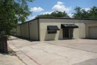
Property Record
908 N Britain Rd, Irving, TX 75061
NEARBY LISTINGS FOR SALE OR LEASE
Property Detail
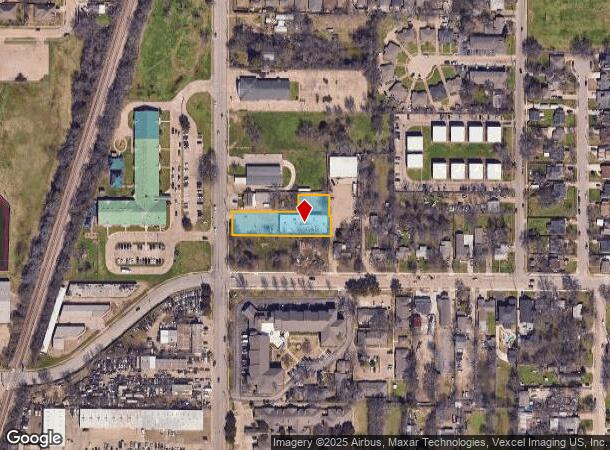
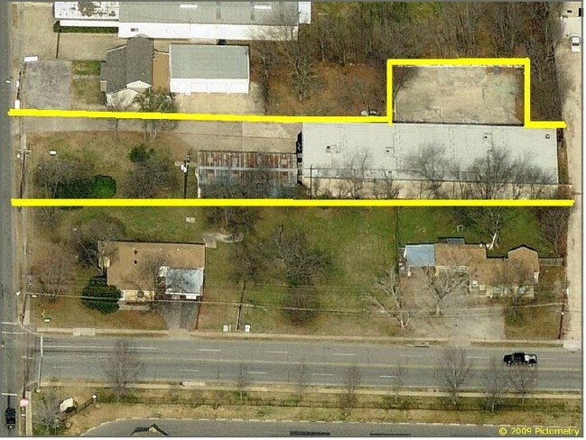
908 N Britain Rd
Dallas-Fort Worth-Arlington, TX
A M A
32000650000010000
A M A LT 1 ACS 0.714 INT201000259432 DD09292010 CO-DC 0006500000100 1CI00065000
Warehouse
Dallas
X
Texas
48113C0305L
1
0
0.71 AC
2025
West Brookhollow
014602
Dallas/Ft Worth
8,736 SF
DEMOGRAPHICS near 908 N Britain Rd
1 Mile
3 Mile
5 Mile
2024 Total Population
19,190
110,866
224,456
2029 Population
18,971
109,670
222,279
Pop Growth 2024-2029
(1.14%)
(1.08%)
(0.97%)
Average Age
35
36
35
2024 Total Households
5,924
36,623
79,111
HH Growth 2024-2029
(1.27%)
(1.28%)
(1.06%)
Median Household Inc
$52,203
$63,547
$62,711
Avg Household Size
3.10
2.90
2.70
2024 Avg HH Vehicles
2.00
2.00
2.00
Median Home Value
$219,639
$222,923
$221,515
Median Year Built
1968
1971
1980
Nearby Places
Map Layers
Map Styles
 Street
 Aerial
- Restaurants
- Banks
- Shops
- Fitness
- Groceries
PUBLIC TRANSPORTATION
COMMUTER RAIL
Downtown Irving/Heritage Crossing Station (TRINITY RAILWAY - Dallas Area Rapid Transit (DART), Trinity Railway Express - Dallas Area Rapid Transit (DART))
DRIVE
WALK
Distance
Downtown Irving/Heritage Crossing Station (TRINITY RAILWAY - Dallas Area Rapid Transit (DART), Trinity Railway Express - Dallas Area Rapid Transit (DART))
3 min
20 min
1.0 mi
West Irving (TRINITY RAILWAY - Dallas Area Rapid Transit (DART), Trinity Railway Express - Dallas Area Rapid Transit (DART))
DRIVE
WALK
Distance
West Irving (TRINITY RAILWAY - Dallas Area Rapid Transit (DART), Trinity Railway Express - Dallas Area Rapid Transit (DART))
11 min
4.5 mi
AIRPORT
Dallas Love Field
DRIVE
WALK
Distance
Dallas Love Field
17 min
9.1 mi
Dallas-Fort Worth International
DRIVE
WALK
Distance
Dallas-Fort Worth International
18 min
11.4 mi
Freight Ports
Port of Shreveport
DRIVE
WALK
Distance
Port of Shreveport
227 min
208.4 mi
Nearby Properties
Address
Land Use
TOTAL SIZE
Lot Size
Zoning
Address
Land Use
TOTAL SIZE
Lot Size
Zoning
1,673,367 SF
17.29 AC
Z243
Address
Land Use
TOTAL SIZE
Lot Size
Zoning
30,000 SF
78.01 AC
Z392
Address
Land Use
TOTAL SIZE
Lot Size
Zoning
654,829 SF
9.78 AC
Z243
Address
Land Use
TOTAL SIZE
Lot Size
Zoning
253,580 SF
188.04 AC
Z393
Address
Land Use
TOTAL SIZE
Lot Size
Zoning
529,640 SF
5.13 AC
Z393
Address
Land Use
TOTAL SIZE
Lot Size
Zoning
573,495 SF
30.30 AC
Z243
Address
Land Use
TOTAL SIZE
Lot Size
Zoning
685,774 SF
7.36 AC
Z198
Address
Land Use
TOTAL SIZE
Lot Size
Zoning
571,923 SF
4.97 AC
Z198
Address
Land Use
TOTAL SIZE
Lot Size
Zoning
949,876 SF
8.39 AC
Z57
Address
Land Use
TOTAL SIZE
Lot Size
Zoning
741,171 SF
3.79 AC
Z198
Address
Land Use
TOTAL SIZE
Lot Size
Zoning
1,102,000 SF
4.98 AC
Z393
Address
Land Use
TOTAL SIZE
Lot Size
Zoning
310,154 SF
10.33 AC
Z393
Address
Land Use
TOTAL SIZE
Lot Size
Zoning
840,836 SF
4.13 AC
Z393
Address
Land Use
TOTAL SIZE
Lot Size
Zoning
348,013 SF
11.09 AC
Z243
Address
Land Use
TOTAL SIZE
Lot Size
Zoning
168,598 SF
11.33 AC
Z128
Address
Land Use
TOTAL SIZE
Lot Size
Zoning
659,704 SF
11.55 AC
Z393
Address
Land Use
TOTAL SIZE
Lot Size
Zoning
643,370 SF
22.95 AC
Z393
Address
Land Use
TOTAL SIZE
Lot Size
Zoning
120,000 SF
9.94 AC
Z393
Address
Land Use
TOTAL SIZE
Lot Size
Zoning
447,043 SF
15.41 AC
Z57
Address
Land Use
TOTAL SIZE
Lot Size
Zoning
268,930 SF
46.40 AC
Z325
Address
Land Use
TOTAL SIZE
Lot Size
Zoning
294,460 SF
14.78 AC
Z392
Address
Land Use
TOTAL SIZE
Lot Size
Zoning
196,928 SF
9.93 AC
Z243
Address
Land Use
TOTAL SIZE
Lot Size
Zoning
141,062 SF
42.31 AC
Z324
Address
Land Use
TOTAL SIZE
Lot Size
Zoning
553,641 SF
3.99 AC
Z393
Address
Land Use
TOTAL SIZE
Lot Size
Zoning
237,472 SF
9.31 AC
Z176
Address
Land Use
TOTAL SIZE
Lot Size
Zoning
137,223 SF
13.14 AC
Z243
Address
Land Use
TOTAL SIZE
Lot Size
Zoning
327,975 SF
18.46 AC
Z393
Address
Land Use
TOTAL SIZE
Lot Size
Zoning
184,910 SF
9.01 AC
Z243
Address
Land Use
TOTAL SIZE
Lot Size
Zoning
242,652 SF
12.31 AC
Z392
Address
Land Use
TOTAL SIZE
Lot Size
Zoning
442,100 SF
3.09 AC
Z393
The World's #1 Commercial Real Estate Marketplace
Connect with us
© 2025 CoStar Group
The information above has been obtained from sources believed reliable. While we do not doubt its accuracy we have not verified it and make no guarantee, warranty or representation about it. It is your responsibility to independently confirm its accuracy and completeness. Any projections, opinions, assumptions, or estimates used are for example only and do not represent the current or future performance of the property. The value of this transaction to you depends on tax and other factors which should be evaluated by your tax, financial, and legal advisors. You and your advisors should conduct a careful, independent investigation of the property to determine to your satisfaction the suitability of the property for your needs.