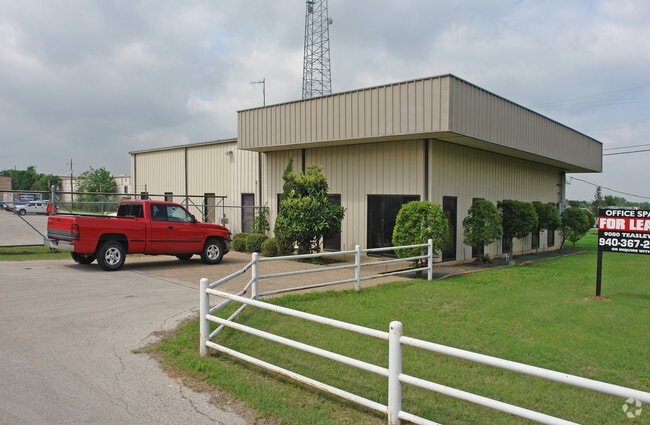
Property Record
9080 Teasley Ln, Denton, TX 76210

Property Detail
9080 Teasley Ln
Dallas-Fort Worth-Arlington, TX
JAY-MAR ADDN BLK 1 LOT 1(PT) (INSIDE CITY)
R152152
Denton
Commercialnec
Texas
B and X Area of moderate flood hazard, usually the area between the limits of the 100-year and 500-year floods.
1
2024
0.66 AC
2025
Lewisville
021410
Dallas/Ft Worth
4,000 SF
NEARBY LISTINGS FOR SALE OR LEASE
DEMOGRAPHICS near 9080 Teasley Ln
1 mile
3 mile
5 mile
2025 Total Population
5,697
60,946
148,263
2030 Population
6,344
67,897
165,871
Pop Growth 2025-2030
+ 11.36%
+ 11.41%
+ 11.88%
Average Age
38
40
40
2025 Total Households
1,890
20,795
52,597
HH Growth 2025-2030
+ 11.69%
+ 11.77%
+ 12.19%
Median Household Inc
$95,317
$124,272
$115,534
Avg Household Size
3.00
2.90
2.80
2025 Avg HH Vehicles
2.00
2.00
2.00
Median Home Value
$366,135
$435,939
$473,081
Median Year Built
2003
2003
2002
Nearby Places
Map Layers
Map Styles
 Street
 Aerial
Transit
 Traffic
 Biking
Places
Listings with unknown addresses are not visible on the map
- Restaurants
- Banks
- Shops
- Fitness
- Groceries
PUBLIC TRANSPORTATION
COMMUTER RAIL
Medpark Station (A-train - Denton County Transportation Authority)
Drive
Walk
Distance
Medpark Station (A-train - Denton County Transportation Authority)
9 min
4.3 mi
Highland Village/Lewisville Lake Station (A-train - Denton County Transportation Authority)
Drive
Walk
Distance
Highland Village/Lewisville Lake Station (A-train - Denton County Transportation Authority)
13 min
8.8 mi
AIRPORT
Dallas-Fort Worth International
Drive
Walk
Distance
Dallas-Fort Worth International
29 min
21.9 mi
Dallas Love Field
Drive
Walk
Distance
Dallas Love Field
41 min
30.9 mi
Freight Ports
Port of Shreveport
Drive
Walk
Distance
Port of Shreveport
248 min
228.5 mi
Nearby Properties
Address
Land Use
TOTAL SIZE
Lot Size
Zoning
Address
Land Use
TOTAL SIZE
Lot Size
Zoning
386,056 SF
81.56 AC
Address
Land Use
TOTAL SIZE
Lot Size
Zoning
360,000 SF
24.34 AC
Address
Land Use
TOTAL SIZE
Lot Size
Zoning
246,535 SF
53.67 AC
Address
Land Use
TOTAL SIZE
Lot Size
Zoning
208,582 SF
8.58 AC
Address
Land Use
TOTAL SIZE
Lot Size
Zoning
191,512 SF
8.04 AC
Address
Land Use
TOTAL SIZE
Lot Size
Zoning
210,801 SF
6.14 AC
Address
Land Use
TOTAL SIZE
Lot Size
Zoning
176,838 SF
15.64 AC
Address
Land Use
TOTAL SIZE
Lot Size
Zoning
178,272 SF
10.25 AC
Address
Land Use
TOTAL SIZE
Lot Size
Zoning
202,197 SF
39.88 AC
Address
Land Use
TOTAL SIZE
Lot Size
Zoning
264,138 SF
38.41 AC
Address
Land Use
TOTAL SIZE
Lot Size
Zoning
185,592 SF
14.38 AC
Address
Land Use
TOTAL SIZE
Lot Size
Zoning
77,887 SF
20.59 AC
Address
Land Use
TOTAL SIZE
Lot Size
Zoning
150,104 SF
11.58 AC
Address
Land Use
TOTAL SIZE
Lot Size
Zoning
157,100 SF
10.44 AC
Address
Land Use
TOTAL SIZE
Lot Size
Zoning
256,043 SF
17.48 AC
Address
Land Use
TOTAL SIZE
Lot Size
Zoning
158,279 SF
53.75 AC
Address
Land Use
TOTAL SIZE
Lot Size
Zoning
116,516 SF
4.20 AC
Address
Land Use
TOTAL SIZE
Lot Size
Zoning
65,556 SF
12.35 AC
Address
Land Use
TOTAL SIZE
Lot Size
Zoning
62,511 SF
5 AC
Address
Land Use
TOTAL SIZE
Lot Size
Zoning
50,905 SF
5.61 AC
Address
Land Use
TOTAL SIZE
Lot Size
Zoning
80,849 SF
4.05 AC
Address
Land Use
TOTAL SIZE
Lot Size
Zoning
90,216 SF
2.76 AC
Address
Land Use
TOTAL SIZE
Lot Size
Zoning
80,935 SF
2.60 AC
Address
Land Use
TOTAL SIZE
Lot Size
Zoning
51,700 SF
7.93 AC
Address
Land Use
TOTAL SIZE
Lot Size
Zoning
108,867 SF
4.81 AC
Address
Land Use
TOTAL SIZE
Lot Size
Zoning
34,592 SF
49.57 AC
Address
Land Use
TOTAL SIZE
Lot Size
Zoning
1,635 SF
45.47 AC
Address
Land Use
TOTAL SIZE
Lot Size
Zoning
72,184 SF
11.39 AC
Address
Land Use
TOTAL SIZE
Lot Size
Zoning
84,377 SF
2.96 AC
Address
Land Use
TOTAL SIZE
Lot Size
Zoning
96,925 SF
2.50 AC
The World's #1 Commercial Real Estate Marketplace
Connect with us
© 2026 CoStar Group
The information above has been obtained from sources believed reliable. While we do not doubt its accuracy we have not verified it and make no guarantee, warranty or representation about it. It is your responsibility to independently confirm its accuracy and completeness. Any projections, opinions, assumptions, or estimates used are for example only and do not represent the current or future performance of the property. The value of this transaction to you depends on tax and other factors which should be evaluated by your tax, financial, and legal advisors. You and your advisors should conduct a careful, independent investigation of the property to determine to your satisfaction the suitability of the property for your needs.