Property Record
9085 Us Highway 42, Union, KY 41091


Save to a Folder
{{folder.Name}}
{{folder.ListingIds.length}} Properties
{{folder.ListingIds.length}} Property
Create a New Folder
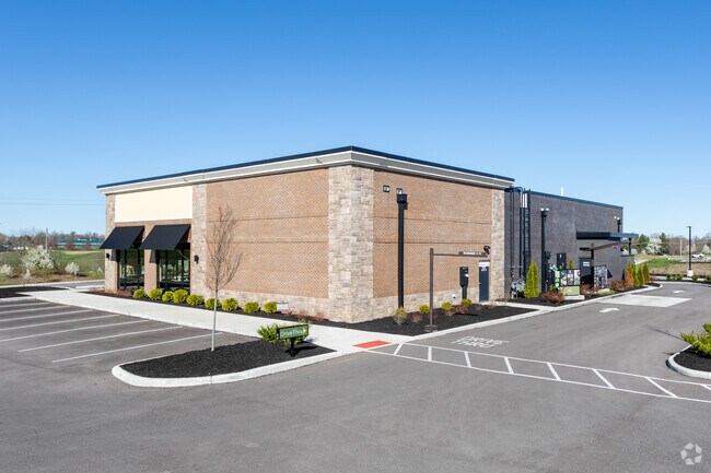
Property Detail
9085 Us Highway 42
Cincinnati, OH-KY-IN
1.7139 AC ON US 42
063.00-00-001.04
BOONE
Restaurantbuilding
Kentucky
B and X Area of moderate flood hazard, usually the area between the limits of the 100-year and 500-year floods.
1.71 AC
2025
Outlying N Kentucky
2025
Cincinnati/Dayton
070316
NEARBY LISTINGS FOR SALE OR LEASE
DEMOGRAPHICS near 9085 Us Highway 42
1 mile
3 mile
5 mile
2025 Total Population
11,265
59,816
114,432
2030 Population
12,060
63,264
120,475
Pop Growth 2025-2030
+ 7.06%
+ 5.76%
+ 5.28%
Average Age
40
39
39
2025 Total Households
4,232
21,479
42,555
HH Growth 2025-2030
+ 7.07%
+ 5.87%
+ 5.37%
Median Household Inc
$111,888
$94,331
$82,325
Avg Household Size
2.60
2.70
2.60
2025 Avg HH Vehicles
2.00
2.00
2.00
Median Home Value
$315,352
$302,910
$268,115
Median Year Built
2004
1998
1994
Nearby Places
Map Layers
Map Styles
 Street
 Aerial
Layers
 Traffic
 Biking
Places
Listings with unknown addresses are not visible on the map
- Restaurants
- Banks
- Shops
- Fitness
- Groceries
PUBLIC TRANSPORTATION
AIRPORT
Cincinnati/Northern Kentucky International
Drive
Walk
Distance
Cincinnati/Northern Kentucky International
22 min
7.8 mi
SALE & LEASE HISTORY
LISTING DATE
SALE/LEASE

May 15, 2019
For Sale
Nearby Properties
Address
Land Use
TOTAL SIZE
Lot Size
Zoning
Address
Land Use
TOTAL SIZE
Lot Size
Zoning
672.11 AC
Address
Land Use
TOTAL SIZE
Lot Size
Zoning
Address
Land Use
TOTAL SIZE
Lot Size
Zoning
73,908 SF
94.57 AC
Address
Land Use
TOTAL SIZE
Lot Size
Zoning
32,250 SF
27.69 AC
Address
Land Use
TOTAL SIZE
Lot Size
Zoning
153.53 AC
Address
Land Use
TOTAL SIZE
Lot Size
Zoning
1,824 SF
7.68 AC
Address
Land Use
TOTAL SIZE
Lot Size
Zoning
27.21 AC
Address
Land Use
TOTAL SIZE
Lot Size
Zoning
14.47 AC
Address
Land Use
TOTAL SIZE
Lot Size
Zoning
112 SF
41.40 AC
Address
Land Use
TOTAL SIZE
Lot Size
Zoning
107,125 SF
12.49 AC
Address
Land Use
TOTAL SIZE
Lot Size
Zoning
19,542 SF
16.64 AC
Address
Land Use
TOTAL SIZE
Lot Size
Zoning
21.50 AC
Address
Land Use
TOTAL SIZE
Lot Size
Zoning
4.62 AC
Address
Land Use
TOTAL SIZE
Lot Size
Zoning
Address
Land Use
TOTAL SIZE
Lot Size
Zoning
17.20 AC
Address
Land Use
TOTAL SIZE
Lot Size
Zoning
1,540 SF
19.04 AC
Address
Land Use
TOTAL SIZE
Lot Size
Zoning
78,848 SF
6.82 AC
Address
Land Use
TOTAL SIZE
Lot Size
Zoning
17.16 AC
Address
Land Use
TOTAL SIZE
Lot Size
Zoning
16.21 AC
Address
Land Use
TOTAL SIZE
Lot Size
Zoning
Address
Land Use
TOTAL SIZE
Lot Size
Zoning
341,388 SF
21.76 AC
Address
Land Use
TOTAL SIZE
Lot Size
Zoning
16.45 AC
Address
Land Use
TOTAL SIZE
Lot Size
Zoning
14.10 AC
Address
Land Use
TOTAL SIZE
Lot Size
Zoning
25.60 AC
Address
Land Use
TOTAL SIZE
Lot Size
Zoning
32.60 AC
Address
Land Use
TOTAL SIZE
Lot Size
Zoning
599,400 SF
60.14 AC
Address
Land Use
TOTAL SIZE
Lot Size
Zoning
17.78 AC
Address
Land Use
TOTAL SIZE
Lot Size
Zoning
4,900 SF
4.06 AC
Address
Land Use
TOTAL SIZE
Lot Size
Zoning
14,352 SF
23.95 AC
Address
Land Use
TOTAL SIZE
Lot Size
Zoning
39.62 AC
The World's #1 Commercial Real Estate Marketplace
Connect with us
© 2026 CoStar Group
The information above has been obtained from sources believed reliable. While we do not doubt its accuracy we have not verified it and make no guarantee, warranty or representation about it. It is your responsibility to independently confirm its accuracy and completeness. Any projections, opinions, assumptions, or estimates used are for example only and do not represent the current or future performance of the property. The value of this transaction to you depends on tax and other factors which should be evaluated by your tax, financial, and legal advisors. You and your advisors should conduct a careful, independent investigation of the property to determine to your satisfaction the suitability of the property for your needs.