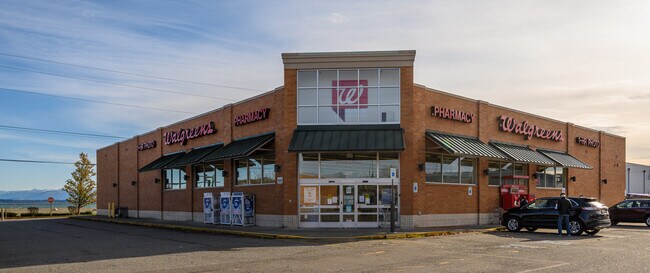
Property Record
909 17Th St, Anacortes, WA 98221

NEARBY LISTINGS FOR SALE OR LEASE
-
-
View all Anacortes listings for sale on LoopNet.com
Property Detail
909 17Th St
Other Market Areas
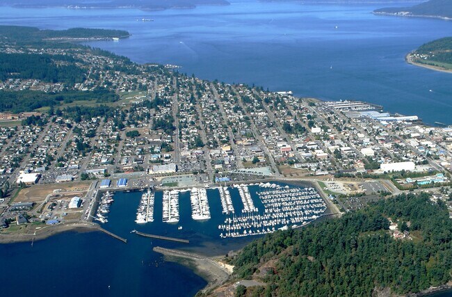
City Of Anacortes
Mount Vernon-Anacortes, WA
PARCEL A: THOSE PORTIONS OF GOVERNMENT LOT 2, SECTION 19, TOWNSHIP 35 NORTH, RANGE 2 EAST, W.M., DESCRIBED AS FOLLOWS: (A) THAT PORTION OF GOVERNMENT LOT 2, SECTION 19, TOWNSHIP 35 NORTH, RANGE 2 EAST, W.M., DESCRIBED AS FOLLOWS: BEGINNING AT THE INT
P32947
Skagit
Storebuilding
Washington
2025
2
2025
1.38 AC
940600
Bellingham/Northwest
13,505 SF
DEMOGRAPHICS near 909 17Th St
1 Mile
3 Mile
5 Mile
2024 Total Population
6,795
18,033
22,780
2029 Population
7,108
18,997
24,042
Pop Growth 2024-2029
+ 4.61%
+ 5.35%
+ 5.54%
Average Age
46
47
48
2024 Total Households
3,181
8,005
10,148
HH Growth 2024-2029
+ 4.65%
+ 5.46%
+ 5.68%
Median Household Inc
$59,496
$80,316
$82,496
Avg Household Size
2.10
2.20
2.20
2024 Avg HH Vehicles
2.00
2.00
2.00
Median Home Value
$555,282
$654,217
$672,475
Median Year Built
1971
1989
1989
Nearby Places
Map Layers
Map Styles
 Street
 Aerial
- Restaurants
- Banks
- Shops
- Fitness
- Groceries
PUBLIC TRANSPORTATION
AIRPORT
Bellingham International
DRIVE
WALK
Distance
Bellingham International
59 min
44.2 mi
Freight Ports
Port of Anacortes
DRIVE
WALK
Distance
Port of Anacortes
2 min
1.0 mi
SALE & LEASE HISTORY
LISTING DATE
SALE/LEASE

Mar 07, 2022
For Sale
Nearby Properties
Address
Land Use
TOTAL SIZE
Lot Size
Zoning
Address
Land Use
TOTAL SIZE
Lot Size
Zoning
336.04 AC
Address
Land Use
TOTAL SIZE
Lot Size
Zoning
14,500 SF
7.92 AC
Address
Land Use
TOTAL SIZE
Lot Size
Zoning
6,155 SF
3.14 AC
Address
Land Use
TOTAL SIZE
Lot Size
Zoning
146,762 SF
2.35 AC
Address
Land Use
TOTAL SIZE
Lot Size
Zoning
18,189 SF
5.94 AC
Address
Land Use
TOTAL SIZE
Lot Size
Zoning
88,838 SF
87 SF
Address
Land Use
TOTAL SIZE
Lot Size
Zoning
126.29 AC
Address
Land Use
TOTAL SIZE
Lot Size
Zoning
40,104 SF
4.66 AC
Address
Land Use
TOTAL SIZE
Lot Size
Zoning
26,785 SF
0.14 AC
Address
Land Use
TOTAL SIZE
Lot Size
Zoning
62,316 SF
3.14 AC
Address
Land Use
TOTAL SIZE
Lot Size
Zoning
105,647 SF
1.29 AC
Address
Land Use
TOTAL SIZE
Lot Size
Zoning
2.18 AC
Address
Land Use
TOTAL SIZE
Lot Size
Zoning
28,181 SF
1.30 AC
Address
Land Use
TOTAL SIZE
Lot Size
Zoning
Address
Land Use
TOTAL SIZE
Lot Size
Zoning
28,478 SF
1.38 AC
Address
Land Use
TOTAL SIZE
Lot Size
Zoning
23,394 SF
0.10 AC
Address
Land Use
TOTAL SIZE
Lot Size
Zoning
185,836 SF
0.16 AC
Address
Land Use
TOTAL SIZE
Lot Size
Zoning
17,873 SF
0.21 AC
Address
Land Use
TOTAL SIZE
Lot Size
Zoning
34,332 SF
1.79 AC
Address
Land Use
TOTAL SIZE
Lot Size
Zoning
59,150 SF
4.45 AC
Address
Land Use
TOTAL SIZE
Lot Size
Zoning
61,484 SF
2.90 AC
Address
Land Use
TOTAL SIZE
Lot Size
Zoning
1,369 SF
0.30 AC
Address
Land Use
TOTAL SIZE
Lot Size
Zoning
15,763 SF
1.22 AC
Address
Land Use
TOTAL SIZE
Lot Size
Zoning
11,692 SF
0.28 AC
Address
Land Use
TOTAL SIZE
Lot Size
Zoning
2,160 SF
9.77 AC
Address
Land Use
TOTAL SIZE
Lot Size
Zoning
Address
Land Use
TOTAL SIZE
Lot Size
Zoning
26,276 SF
2.04 AC
Address
Land Use
TOTAL SIZE
Lot Size
Zoning
36,480 SF
4.24 AC
Address
Land Use
TOTAL SIZE
Lot Size
Zoning
56,590 SF
1.81 AC
Address
Land Use
TOTAL SIZE
Lot Size
Zoning
744 SF
44 SF
The World's #1 Commercial Real Estate Marketplace
Connect with us
© 2025 CoStar Group
The information above has been obtained from sources believed reliable. While we do not doubt its accuracy we have not verified it and make no guarantee, warranty or representation about it. It is your responsibility to independently confirm its accuracy and completeness. Any projections, opinions, assumptions, or estimates used are for example only and do not represent the current or future performance of the property. The value of this transaction to you depends on tax and other factors which should be evaluated by your tax, financial, and legal advisors. You and your advisors should conduct a careful, independent investigation of the property to determine to your satisfaction the suitability of the property for your needs.