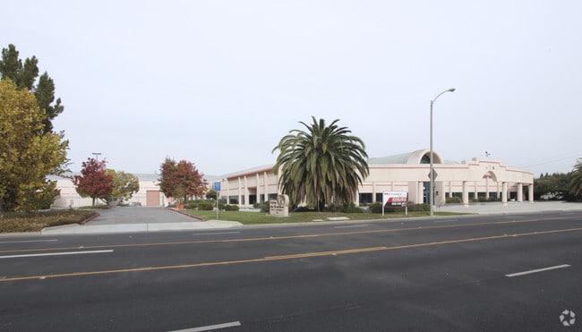
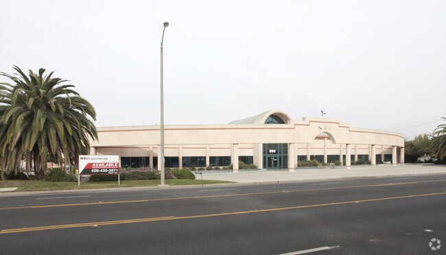
Property Record
909 Kifer Rd, Sunnyvale, CA 94086

Save to a Folder
{{folder.Name}}
{{folder.ListingIds.length}} Properties
{{folder.ListingIds.length}} Property
Create a New Folder
Property Detail
909 Kifer Rd
205-42-014
SANTA CLARA
Industrialgeneral
California
MS
18.69 AC
2025
Sunnyvale
2025
South Bay/San Jose
508708
San Jose-Sunnyvale-Santa Clara, CA
162,205 SF
NEARBY LISTINGS FOR SALE OR LEASE
DEMOGRAPHICS near 909 Kifer Rd
1 mile
3 mile
5 mile
2025 Total Population
29,425
219,714
489,832
2030 Population
30,705
226,468
503,326
Pop Growth 2025-2030
+ 4.35%
+ 3.07%
+ 2.75%
Average Age
36
38
39
2025 Total Households
11,397
82,705
183,541
HH Growth 2025-2030
+ 4.50%
+ 3.14%
+ 2.82%
Median Household Inc
$191,492
$182,491
$183,617
Avg Household Size
2.50
2.60
2.60
2025 Avg HH Vehicles
2.00
2.00
2.00
Median Home Value
$1,115,189
$1,105,385
$1,118,269
Median Year Built
1986
1976
1974
Nearby Places
Map Layers
Map Styles
 Street
 Aerial
Layers
 Traffic
 Biking
Places
Listings with unknown addresses are not visible on the map
- Restaurants
- Banks
- Shops
- Fitness
- Groceries
PUBLIC TRANSPORTATION
COMMUTER RAIL
Lawrence Caltrain Station Southbound (Limited - Caltrain (Caltrain), Local Weekday - Caltrain (Caltrain), Local Weekend - Caltrain (Caltrain))
Drive
Walk
Distance
Lawrence Caltrain Station Southbound (Limited - Caltrain (Caltrain), Local Weekday - Caltrain (Caltrain), Local Weekend - Caltrain (Caltrain))
2 min
1.0 mi
Sunnyvale Caltrain Station Southbound (Express - Caltrain (Caltrain), Limited - Caltrain (Caltrain), Local Weekday - Caltrain (Caltrain), Local Weekend - Caltrain (Caltrain))
Drive
Walk
Distance
Sunnyvale Caltrain Station Southbound (Express - Caltrain (Caltrain), Limited - Caltrain (Caltrain), Local Weekday - Caltrain (Caltrain), Local Weekend - Caltrain (Caltrain))
4 min
1.4 mi
AIRPORT
Norman Y Mineta San Jose International
Drive
Walk
Distance
Norman Y Mineta San Jose International
9 min
5.2 mi
San Francisco International
Drive
Walk
Distance
San Francisco International
39 min
29.1 mi
Metro Oakland International
Drive
Walk
Distance
Metro Oakland International
48 min
37.0 mi
Freight Ports
Port of Redwood City
Drive
Walk
Distance
Port of Redwood City
24 min
16.0 mi
Nearby Properties
Address
Land Use
TOTAL SIZE
Lot Size
Zoning
Address
Land Use
TOTAL SIZE
Lot Size
Zoning
553,793 SF
38.06 AC
ML
Address
Land Use
TOTAL SIZE
Lot Size
Zoning
2,819,800 SF
91.85 AC
CU
Address
Land Use
TOTAL SIZE
Lot Size
Zoning
777,000 SF
17.84 AC
MS
Address
Land Use
TOTAL SIZE
Lot Size
Zoning
0.06 AC
PD
Address
Land Use
TOTAL SIZE
Lot Size
Zoning
424,316 SF
22.37 AC
SU
Address
Land Use
TOTAL SIZE
Lot Size
Zoning
318,172 SF
60.47 AC
MP-TO
Address
Land Use
TOTAL SIZE
Lot Size
Zoning
107,203 SF
21.74 AC
MXD2
Address
Land Use
TOTAL SIZE
Lot Size
Zoning
238,239 SF
24.67 AC
PD
Address
Land Use
TOTAL SIZE
Lot Size
Zoning
111,585 SF
6.69 AC
ML
Address
Land Use
TOTAL SIZE
Lot Size
Zoning
16.72 AC
MSLSP
Address
Land Use
TOTAL SIZE
Lot Size
Zoning
181,562 SF
16.51 AC
ML
Address
Land Use
TOTAL SIZE
Lot Size
Zoning
818,051 SF
13.81 AC
CP
Address
Land Use
TOTAL SIZE
Lot Size
Zoning
73,425 SF
14.20 AC
MS
Address
Land Use
TOTAL SIZE
Lot Size
Zoning
4 AC
DSP/1
Address
Land Use
TOTAL SIZE
Lot Size
Zoning
81,250 SF
14.73 AC
MPT
Address
Land Use
TOTAL SIZE
Lot Size
Zoning
431,256 SF
12.43 AC
PPSP
Address
Land Use
TOTAL SIZE
Lot Size
Zoning
350,633 SF
1.08 AC
MPTOD
Address
Land Use
TOTAL SIZE
Lot Size
Zoning
350,633 SF
1.27 AC
MPTOD
Address
Land Use
TOTAL SIZE
Lot Size
Zoning
350,633 SF
1.08 AC
MPTOD
Address
Land Use
TOTAL SIZE
Lot Size
Zoning
180,846 SF
12.19 AC
ML
Address
Land Use
TOTAL SIZE
Lot Size
Zoning
587,826 SF
2.54 AC
DSP/1
Address
Land Use
TOTAL SIZE
Lot Size
Zoning
353,745 SF
14.82 AC
PPSP
Address
Land Use
TOTAL SIZE
Lot Size
Zoning
17.25 AC
MPI
Address
Land Use
TOTAL SIZE
Lot Size
Zoning
531,132 SF
21.33 AC
R4PD
Address
Land Use
TOTAL SIZE
Lot Size
Zoning
107.73 AC
CT
Address
Land Use
TOTAL SIZE
Lot Size
Zoning
208,562 SF
9.10 AC
CP
Address
Land Use
TOTAL SIZE
Lot Size
Zoning
23,709 SF
7.48 AC
PPSP
Address
Land Use
TOTAL SIZE
Lot Size
Zoning
22,400 SF
11.43 AC
MP-TO
The World's #1 Commercial Real Estate Marketplace
Connect with us
© 2026 CoStar Group
The information above has been obtained from sources believed reliable. While we do not doubt its accuracy we have not verified it and make no guarantee, warranty or representation about it. It is your responsibility to independently confirm its accuracy and completeness. Any projections, opinions, assumptions, or estimates used are for example only and do not represent the current or future performance of the property. The value of this transaction to you depends on tax and other factors which should be evaluated by your tax, financial, and legal advisors. You and your advisors should conduct a careful, independent investigation of the property to determine to your satisfaction the suitability of the property for your needs.