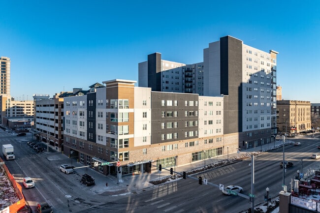
Property Record
909 Q St, Lincoln, NE 68508

NEARBY LISTINGS FOR SALE OR LEASE
Property Detail
909 Q St
Lincoln
Collegiate Addition
Lincoln, NE
COLLEGIATE ADDITION, LOT 2
10-23-453-002-000
Lancaster
Commercialnec
Nebraska
2024
2
2025
1.22 AC
001900
Downtown Lincoln
134,835 SF
DEMOGRAPHICS near 909 Q St
1 Mile
3 Mile
5 Mile
2024 Total Population
15,762
102,388
219,156
2029 Population
16,459
106,209
227,112
Pop Growth 2024-2029
+ 4.42%
+ 3.73%
+ 3.63%
Average Age
31
35
37
2024 Total Households
6,846
42,510
90,726
HH Growth 2024-2029
+ 5.40%
+ 4.00%
+ 3.82%
Median Household Inc
$30,474
$46,307
$56,300
Avg Household Size
1.80
2.20
2.30
2024 Avg HH Vehicles
1.00
2.00
2.00
Median Home Value
$116,402
$169,626
$194,402
Median Year Built
1967
1968
1974
Nearby Places
Map Layers
Map Styles
 Street
 Aerial
- Restaurants
- Banks
- Shops
- Fitness
- Groceries
PUBLIC TRANSPORTATION
COMMUTER RAIL
DRIVE
WALK
Distance
1 min
6 min
0.3 mi
AIRPORT
Lincoln
DRIVE
WALK
Distance
Lincoln
10 min
4.8 mi
Nearby Properties
Address
Land Use
TOTAL SIZE
Lot Size
Zoning
Address
Land Use
TOTAL SIZE
Lot Size
Zoning
684,598 SF
21.16 AC
B3
Address
Land Use
TOTAL SIZE
Lot Size
Zoning
131,328 SF
2.07 AC
P
Address
Land Use
TOTAL SIZE
Lot Size
Zoning
65,430 SF
1.12 AC
B4
Address
Land Use
TOTAL SIZE
Lot Size
Zoning
182,668 SF
2.07 AC
B4
Address
Land Use
TOTAL SIZE
Lot Size
Zoning
35,233 SF
28.52 AC
NULL
Address
Land Use
TOTAL SIZE
Lot Size
Zoning
72,047 SF
1.03 AC
B4
Address
Land Use
TOTAL SIZE
Lot Size
Zoning
216,894 SF
1.47 AC
B4
Address
Land Use
TOTAL SIZE
Lot Size
Zoning
708,074 SF
66.04 AC
I1
Address
Land Use
TOTAL SIZE
Lot Size
Zoning
71,046 SF
23.72 AC
R5
Address
Land Use
TOTAL SIZE
Lot Size
Zoning
217,115 SF
2.03 AC
B4
Address
Land Use
TOTAL SIZE
Lot Size
Zoning
189,854 SF
2.07 AC
P
Address
Land Use
TOTAL SIZE
Lot Size
Zoning
287,193 SF
6.62 AC
B4
Address
Land Use
TOTAL SIZE
Lot Size
Zoning
174,576 SF
2.07 AC
R6
Address
Land Use
TOTAL SIZE
Lot Size
Zoning
92,418 SF
0.79 AC
B4
Address
Land Use
TOTAL SIZE
Lot Size
Zoning
119,257 SF
1.68 AC
B4
Address
Land Use
TOTAL SIZE
Lot Size
Zoning
180,578 SF
1.32 AC
P
Address
Land Use
TOTAL SIZE
Lot Size
Zoning
56,867 SF
22.10 AC
NULL
Address
Land Use
TOTAL SIZE
Lot Size
Zoning
11.90 AC
P
Address
Land Use
TOTAL SIZE
Lot Size
Zoning
119,655 SF
2.28 AC
B4
Address
Land Use
TOTAL SIZE
Lot Size
Zoning
92,505 SF
2.96 AC
B4
Address
Land Use
TOTAL SIZE
Lot Size
Zoning
63,003 SF
1.22 AC
O3
Address
Land Use
TOTAL SIZE
Lot Size
Zoning
47,017 SF
0.92 AC
B4
Address
Land Use
TOTAL SIZE
Lot Size
Zoning
23,881 SF
0.80 AC
B4
Address
Land Use
TOTAL SIZE
Lot Size
Zoning
121,860 SF
6.51 AC
P
Address
Land Use
TOTAL SIZE
Lot Size
Zoning
317,607 SF
20.81 AC
I2
Address
Land Use
TOTAL SIZE
Lot Size
Zoning
60,761 SF
0.75 AC
B4
Address
Land Use
TOTAL SIZE
Lot Size
Zoning
110,512 SF
0.98 AC
O1
Address
Land Use
TOTAL SIZE
Lot Size
Zoning
33,730 SF
6.88 AC
NULL
Address
Land Use
TOTAL SIZE
Lot Size
Zoning
149,344 SF
1.57 AC
P
The World's #1 Commercial Real Estate Marketplace
Connect with us
© 2025 CoStar Group
The information above has been obtained from sources believed reliable. While we do not doubt its accuracy we have not verified it and make no guarantee, warranty or representation about it. It is your responsibility to independently confirm its accuracy and completeness. Any projections, opinions, assumptions, or estimates used are for example only and do not represent the current or future performance of the property. The value of this transaction to you depends on tax and other factors which should be evaluated by your tax, financial, and legal advisors. You and your advisors should conduct a careful, independent investigation of the property to determine to your satisfaction the suitability of the property for your needs.