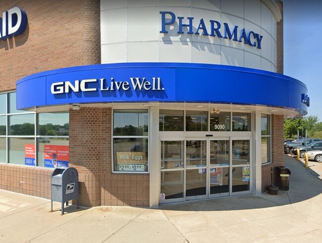
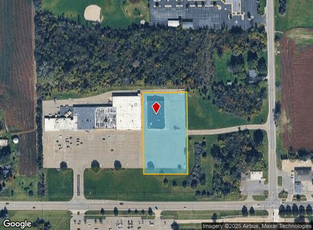
Property Record
9090 Miller Rd, Swartz Creek, MI 48473
NEARBY LISTINGS FOR SALE OR LEASE
Property Detail
9090 Miller Rd
04-34-400-014
A PARCEL OF LAND BEG N 89 DEG 56 MIN W 289.43 FT & N 89 DEG 12 MIN 30 SEC W 1022.26 FFT & N 0 DEG 06 MIN 20 SEC W 640.74 FT &
Commercialnec
Genesee
X
Michigan
26049C0278D
2.57 AC
2024
Flint
2025
Detroit
012703
Flint, MI
14,450 SF
DEMOGRAPHICS near 9090 Miller Rd
1 Mile
3 Mile
5 Mile
2024 Total Population
4,038
10,611
26,871
2029 Population
3,873
10,248
26,127
Pop Growth 2024-2029
(4.09%)
(3.42%)
(2.77%)
Average Age
43
44
44
2024 Total Households
1,668
4,467
11,269
HH Growth 2024-2029
(4.08%)
(3.38%)
(2.72%)
Median Household Inc
$66,327
$64,906
$63,265
Avg Household Size
2.40
2.30
2.30
2024 Avg HH Vehicles
2.00
2.00
2.00
Median Home Value
$164,038
$172,573
$172,485
Median Year Built
1970
1976
1974
Nearby Places
Map Layers
Map Styles
 Street
 Aerial
- Restaurants
- Banks
- Shops
- Fitness
- Groceries
PUBLIC TRANSPORTATION
COMMUTER RAIL
Durand Amtrak Station (Blue Water - Amtrak)
DRIVE
WALK
Distance
Durand Amtrak Station (Blue Water - Amtrak)
17 min
8.8 mi
AIRPORT
Bishop International
DRIVE
WALK
Distance
Bishop International
22 min
6.7 mi
Freight Ports
Port of Toledo
DRIVE
WALK
Distance
Port of Toledo
140 min
117.5 mi
SALE & LEASE HISTORY
LISTING DATE
SALE/LEASE

May 23, 2025
For Lease
Nearby Properties
Address
Land Use
TOTAL SIZE
Lot Size
Zoning
Address
Land Use
TOTAL SIZE
Lot Size
Zoning
179,638 SF
17.78 AC
RM-1
Address
Land Use
TOTAL SIZE
Lot Size
Zoning
190,917 SF
58.79 AC
GBD
Address
Land Use
TOTAL SIZE
Lot Size
Zoning
91,712 SF
9 AC
RM-1
Address
Land Use
TOTAL SIZE
Lot Size
Zoning
127,924 SF
22.33 AC
RM-1
Address
Land Use
TOTAL SIZE
Lot Size
Zoning
64,065 SF
9.19 AC
GBD
Address
Land Use
TOTAL SIZE
Lot Size
Zoning
132,260 SF
14.50 AC
RM-1
Address
Land Use
TOTAL SIZE
Lot Size
Zoning
44,297 SF
3.69 AC
GBD
Address
Land Use
TOTAL SIZE
Lot Size
Zoning
32,397 SF
4.61 AC
Address
Land Use
TOTAL SIZE
Lot Size
Zoning
95,715 SF
6.63 AC
Address
Land Use
TOTAL SIZE
Lot Size
Zoning
38,000 SF
11.44 AC
Address
Land Use
TOTAL SIZE
Lot Size
Zoning
616 SF
43.55 AC
RM-1
Address
Land Use
TOTAL SIZE
Lot Size
Zoning
64,352 SF
12.02 AC
GC,GENE
Address
Land Use
TOTAL SIZE
Lot Size
Zoning
87,000 SF
9.36 AC
I-1
Address
Land Use
TOTAL SIZE
Lot Size
Zoning
3,024 SF
27 AC
MHP
Address
Land Use
TOTAL SIZE
Lot Size
Zoning
23,692 SF
Address
Land Use
TOTAL SIZE
Lot Size
Zoning
60,825 SF
108.58 AC
I-1
Address
Land Use
TOTAL SIZE
Lot Size
Zoning
47,500 SF
5.78 AC
Address
Land Use
TOTAL SIZE
Lot Size
Zoning
Address
Land Use
TOTAL SIZE
Lot Size
Zoning
5,066 SF
2.96 AC
NBD
Address
Land Use
TOTAL SIZE
Lot Size
Zoning
16,773 SF
3.02 AC
NBD
Address
Land Use
TOTAL SIZE
Lot Size
Zoning
3,278 SF
197.90 AC
RA,AGRI
Address
Land Use
TOTAL SIZE
Lot Size
Zoning
51,200 SF
4.39 AC
I-1
Address
Land Use
TOTAL SIZE
Lot Size
Zoning
19,404 SF
1.97 AC
RM
Address
Land Use
TOTAL SIZE
Lot Size
Zoning
277.11 AC
RE,RURA
Address
Land Use
TOTAL SIZE
Lot Size
Zoning
8,872 SF
3.08 AC
RM-1
Address
Land Use
TOTAL SIZE
Lot Size
Zoning
4,699 SF
2.17 AC
GBD
Address
Land Use
TOTAL SIZE
Lot Size
Zoning
25,435 SF
3.41 AC
GBD
Address
Land Use
TOTAL SIZE
Lot Size
Zoning
3,376 SF
43 AC
Address
Land Use
TOTAL SIZE
Lot Size
Zoning
3,023 SF
1.55 AC
GBD
The World's #1 Commercial Real Estate Marketplace
Connect with us
© 2026 CoStar Group
The information above has been obtained from sources believed reliable. While we do not doubt its accuracy we have not verified it and make no guarantee, warranty or representation about it. It is your responsibility to independently confirm its accuracy and completeness. Any projections, opinions, assumptions, or estimates used are for example only and do not represent the current or future performance of the property. The value of this transaction to you depends on tax and other factors which should be evaluated by your tax, financial, and legal advisors. You and your advisors should conduct a careful, independent investigation of the property to determine to your satisfaction the suitability of the property for your needs.