Property Record
9091 Chillicothe Rd, Willoughby, OH 44094

NEARBY LISTINGS FOR SALE OR LEASE
Property Detail
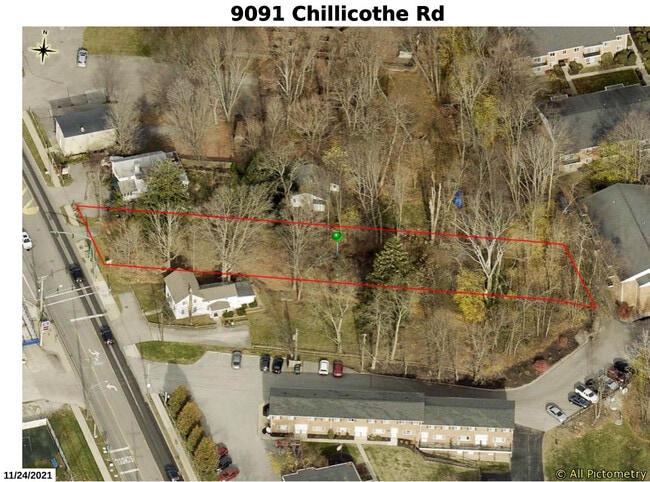
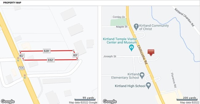
9091 Chillicothe Rd
20-A-006-A-00-074
LOT 30 TRACT 1
Residentialacreage
Lake
X
Ohio
39085C0201F
30
0
0.41 AC
2024
Northeast
203700
Cleveland
576 SF
Cleveland-Elyria, OH
DEMOGRAPHICS near 9091 Chillicothe Rd
1 Mile
3 Mile
5 Mile
2024 Total Population
1,547
19,685
80,971
2029 Population
1,549
19,778
80,852
Pop Growth 2024-2029
+ 0.13%
+ 0.47%
(0.15%)
Average Age
45
45
45
2024 Total Households
609
8,652
35,912
HH Growth 2024-2029
0.00%
+ 0.62%
(0.08%)
Median Household Inc
$114,622
$85,784
$79,292
Avg Household Size
2.50
2.20
2.20
2024 Avg HH Vehicles
2.00
2.00
2.00
Median Home Value
$414,800
$273,315
$211,994
Median Year Built
1981
1973
1972
Nearby Places
Map Layers
Map Styles
 Street
 Aerial
- Restaurants
- Banks
- Shops
- Fitness
- Groceries
PUBLIC TRANSPORTATION
AIRPORT
Cleveland-Hopkins International
DRIVE
WALK
Distance
Cleveland-Hopkins International
51 min
36.1 mi
Freight Ports
Port of Toledo
DRIVE
WALK
Distance
Port of Toledo
165 min
136.5 mi
SALE & LEASE HISTORY
LISTING DATE
SALE/LEASE

Sep 24, 2016
For Sale
Apr 06, 2023
For Sale
Nearby Properties
Address
Land Use
TOTAL SIZE
Lot Size
Zoning
Address
Land Use
TOTAL SIZE
Lot Size
Zoning
455,945 SF
78.40 AC
B-1
Address
Land Use
TOTAL SIZE
Lot Size
Zoning
747,384 SF
42.35 AC
Address
Land Use
TOTAL SIZE
Lot Size
Zoning
327,593 SF
103.27 AC
Address
Land Use
TOTAL SIZE
Lot Size
Zoning
45,768 SF
13.53 AC
Address
Land Use
TOTAL SIZE
Lot Size
Zoning
148,642 SF
15.03 AC
Address
Land Use
TOTAL SIZE
Lot Size
Zoning
214,881 SF
47.99 AC
S-5
Address
Land Use
TOTAL SIZE
Lot Size
Zoning
42.35 AC
Address
Land Use
TOTAL SIZE
Lot Size
Zoning
212,280 SF
17.96 AC
B-2
Address
Land Use
TOTAL SIZE
Lot Size
Zoning
127,458 SF
67.34 AC
R-4
Address
Land Use
TOTAL SIZE
Lot Size
Zoning
233,534 SF
26.21 AC
B-2
Address
Land Use
TOTAL SIZE
Lot Size
Zoning
93,171 SF
7.14 AC
Address
Land Use
TOTAL SIZE
Lot Size
Zoning
141,900 SF
11.72 AC
B-2
Address
Land Use
TOTAL SIZE
Lot Size
Zoning
159,043 SF
11.61 AC
B2
Address
Land Use
TOTAL SIZE
Lot Size
Zoning
74,622 SF
10 AC
Address
Land Use
TOTAL SIZE
Lot Size
Zoning
168,150 SF
14.21 AC
R-10
Address
Land Use
TOTAL SIZE
Lot Size
Zoning
98,819 SF
2.94 AC
B2
Address
Land Use
TOTAL SIZE
Lot Size
Zoning
88,958 SF
5.07 AC
Address
Land Use
TOTAL SIZE
Lot Size
Zoning
95,798 SF
222.29 AC
R-1
Address
Land Use
TOTAL SIZE
Lot Size
Zoning
174,384 SF
11.19 AC
M-1
Address
Land Use
TOTAL SIZE
Lot Size
Zoning
20,924 SF
46.94 AC
Address
Land Use
TOTAL SIZE
Lot Size
Zoning
168,880 SF
14.20 AC
Address
Land Use
TOTAL SIZE
Lot Size
Zoning
20,383 SF
3.48 AC
Address
Land Use
TOTAL SIZE
Lot Size
Zoning
91,288 SF
26.56 AC
R-4
Address
Land Use
TOTAL SIZE
Lot Size
Zoning
41,030 SF
2.61 AC
R-3
Address
Land Use
TOTAL SIZE
Lot Size
Zoning
62,109 SF
4.93 AC
Address
Land Use
TOTAL SIZE
Lot Size
Zoning
144,964 SF
9.70 AC
R-10
Address
Land Use
TOTAL SIZE
Lot Size
Zoning
126,944 SF
11.90 AC
R10
Address
Land Use
TOTAL SIZE
Lot Size
Zoning
13,528 SF
48.99 AC
C-1
Address
Land Use
TOTAL SIZE
Lot Size
Zoning
89,942 SF
5.12 AC
B-2
Address
Land Use
TOTAL SIZE
Lot Size
Zoning
79,866 SF
6.45 AC
R2
The World's #1 Commercial Real Estate Marketplace
Connect with us
© 2025 CoStar Group
The information above has been obtained from sources believed reliable. While we do not doubt its accuracy we have not verified it and make no guarantee, warranty or representation about it. It is your responsibility to independently confirm its accuracy and completeness. Any projections, opinions, assumptions, or estimates used are for example only and do not represent the current or future performance of the property. The value of this transaction to you depends on tax and other factors which should be evaluated by your tax, financial, and legal advisors. You and your advisors should conduct a careful, independent investigation of the property to determine to your satisfaction the suitability of the property for your needs.