Property Record
91 Fort Weaver Rd, , HI
Property Detail
91 Fort Weaver Rd
Urban Honolulu, HI
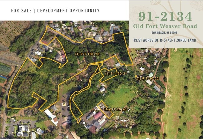
LOT 31 MAP 13 LCAPP 1069
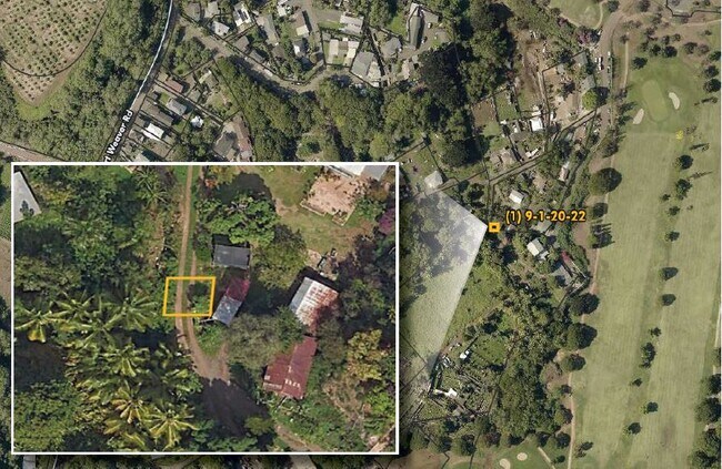
1-9-1-181-023-0000
HONOLULU
Agriculturalland
Hawaii
R-5
31
2024
11.68 AC
2025
West Oahu
008415
Hawaii
NEARBY LISTINGS FOR SALE OR LEASE
DEMOGRAPHICS near 91 Fort Weaver Rd
1 mile
3 mile
5 mile
2025 Total Population
7,796
107,128
219,828
2030 Population
7,823
106,372
217,870
Pop Growth 2025-2030
+ 0.35%
(0.71%)
(0.89%)
Average Age
41
39
39
2025 Total Households
2,042
28,114
61,537
HH Growth 2025-2030
(0.34%)
(0.99%)
(1.23%)
Median Household Inc
$122,484
$118,240
$119,912
Avg Household Size
3.70
3.50
3.30
2025 Avg HH Vehicles
2.00
2.00
2.00
Median Home Value
$753,808
$785,063
$794,016
Median Year Built
1990
1993
1990
Nearby Places
Map Layers
Map Styles
 Street
 Aerial
Layers
 Traffic
 Biking
Places
Listings with unknown addresses are not visible on the map
- Restaurants
- Banks
- Shops
- Fitness
- Groceries
PUBLIC TRANSPORTATION
TRANSIT/SUBWAY
Ho'ae'ae West Loch Station (SKYLINE - DTS)
Drive
Walk
Distance
Ho'ae'ae West Loch Station (SKYLINE - DTS)
2 min
19 min
1.0 mi
AIRPORT
Daniel K Inouye International
Drive
Walk
Distance
Daniel K Inouye International
19 min
12.2 mi
Freight Ports
Honolulu Harbor, Oahu
Drive
Walk
Distance
Honolulu Harbor, Oahu
27 min
16.3 mi
SALE & LEASE HISTORY
LISTING DATE
SALE/LEASE

Aug 27, 2024
For Sale
Nearby Properties
Address
Land Use
TOTAL SIZE
Lot Size
Zoning
Address
Land Use
TOTAL SIZE
Lot Size
Zoning
310,432 SF
192.56 AC
BMX-3
Address
Land Use
TOTAL SIZE
Lot Size
Zoning
645,869 SF
48.95 AC
AG-1
Address
Land Use
TOTAL SIZE
Lot Size
Zoning
376,136 SF
32.06 AC
B-2
Address
Land Use
TOTAL SIZE
Lot Size
Zoning
48.66 AC
I-2
Address
Land Use
TOTAL SIZE
Lot Size
Zoning
227,309 SF
16.77 AC
B-2
Address
Land Use
TOTAL SIZE
Lot Size
Zoning
8,600 SF
479.12 AC
F-1
Address
Land Use
TOTAL SIZE
Lot Size
Zoning
82,948 SF
16.06 AC
AG-1
Address
Land Use
TOTAL SIZE
Lot Size
Zoning
229,396 SF
11.31 AC
BMX-3
Address
Land Use
TOTAL SIZE
Lot Size
Zoning
2,225 SF
19.72 AC
AG-1
Address
Land Use
TOTAL SIZE
Lot Size
Zoning
1,714 SF
200.33 AC
AG-1
Address
Land Use
TOTAL SIZE
Lot Size
Zoning
102,877 SF
9.77 AC
B-2
Address
Land Use
TOTAL SIZE
Lot Size
Zoning
13.47 AC
AMX-2
Address
Land Use
TOTAL SIZE
Lot Size
Zoning
29.14 AC
IMX-1
Address
Land Use
TOTAL SIZE
Lot Size
Zoning
148.81 AC
P-2
Address
Land Use
TOTAL SIZE
Lot Size
Zoning
424,593 SF
8.73 AC
B-2
Address
Land Use
TOTAL SIZE
Lot Size
Zoning
41,964 SF
69.57 AC
F-1
Address
Land Use
TOTAL SIZE
Lot Size
Zoning
157,460 SF
9.51 AC
BMX-3
Address
Land Use
TOTAL SIZE
Lot Size
Zoning
91,808 SF
6.59 AC
BMX-3
Address
Land Use
TOTAL SIZE
Lot Size
Zoning
108,786 SF
7.09 AC
BMX-3
Address
Land Use
TOTAL SIZE
Lot Size
Zoning
5,278 SF
57.87 AC
P-2
Address
Land Use
TOTAL SIZE
Lot Size
Zoning
60,135 SF
4.90 AC
B-2
Address
Land Use
TOTAL SIZE
Lot Size
Zoning
53.41 AC
P-2
Address
Land Use
TOTAL SIZE
Lot Size
Zoning
416.48 AC
F-1
Address
Land Use
TOTAL SIZE
Lot Size
Zoning
119,778 SF
4.55 AC
B-1
Address
Land Use
TOTAL SIZE
Lot Size
Zoning
131,855 SF
14.48 AC
AG-1
Address
Land Use
TOTAL SIZE
Lot Size
Zoning
67.86 AC
R-3.5
Address
Land Use
TOTAL SIZE
Lot Size
Zoning
31,599 SF
0.55 AC
AG-1
Address
Land Use
TOTAL SIZE
Lot Size
Zoning
68,487 SF
3.78 AC
R-5
Address
Land Use
TOTAL SIZE
Lot Size
Zoning
5.71 AC
A-2
Address
Land Use
TOTAL SIZE
Lot Size
Zoning
132,108 SF
4.37 AC
B-2
The World's #1 Commercial Real Estate Marketplace
Connect with us
© 2026 CoStar Group
The information above has been obtained from sources believed reliable. While we do not doubt its accuracy we have not verified it and make no guarantee, warranty or representation about it. It is your responsibility to independently confirm its accuracy and completeness. Any projections, opinions, assumptions, or estimates used are for example only and do not represent the current or future performance of the property. The value of this transaction to you depends on tax and other factors which should be evaluated by your tax, financial, and legal advisors. You and your advisors should conduct a careful, independent investigation of the property to determine to your satisfaction the suitability of the property for your needs.