Property Record
91 Fort Weaver Rd, Ewa Beach, HI 96706
NEARBY LISTINGS FOR SALE OR LEASE
Property Detail
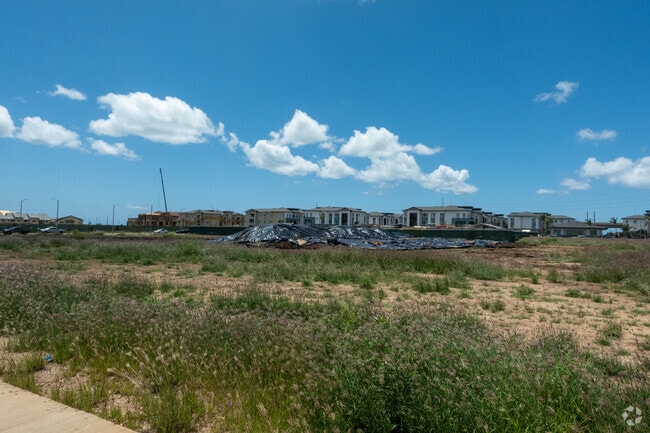
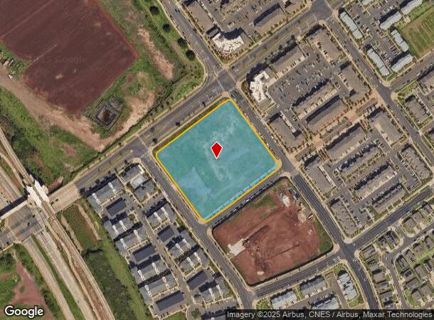
91 Fort Weaver Rd
Urban Honolulu, HI
LOT 20140 4.901 AC MAP 1693 LCAPP 1069 TOG/ESMT
1-9-1-017-166-0000
Honolulu
Commercialnec
Hawaii
D
20140
15003C0310G
4.90 AC
2024
West Oahu
2025
Hawaii
008627
DEMOGRAPHICS near 91 Fort Weaver Rd
1 Mile
3 Mile
5 Mile
2024 Total Population
8,430
98,419
154,683
2029 Population
8,091
94,169
147,545
Pop Growth 2024-2029
(4.02%)
(4.32%)
(4.61%)
Average Age
32
37
38
2024 Total Households
2,193
27,642
42,855
HH Growth 2024-2029
(4.79%)
(4.83%)
(5.26%)
Median Household Inc
$108,333
$109,548
$108,286
Avg Household Size
3.70
3.40
3.40
2024 Avg HH Vehicles
2.00
2.00
2.00
Median Home Value
$739,414
$714,751
$718,579
Median Year Built
2008
1996
1994
Nearby Places
Map Layers
Map Styles
 Street
 Aerial
- Restaurants
- Banks
- Shops
- Fitness
- Groceries
PUBLIC TRANSPORTATION
TRANSIT/SUBWAY
Keone'ae U.H. West Oahu Station (SKYLINE - DTS)
DRIVE
WALK
Distance
Keone'ae U.H. West Oahu Station (SKYLINE - DTS)
0 min
5 min
0.3 mi
Honouliuli Ho'opili Station (SKYLINE - DTS)
DRIVE
WALK
Distance
Honouliuli Ho'opili Station (SKYLINE - DTS)
2 min
15 min
0.7 mi
AIRPORT
Daniel K Inouye International
DRIVE
WALK
Distance
Daniel K Inouye International
22 min
15.0 mi
Freight Ports
Honolulu Harbor, Oahu
DRIVE
WALK
Distance
Honolulu Harbor, Oahu
31 min
19.2 mi
Nearby Properties
Address
Land Use
TOTAL SIZE
Lot Size
Zoning
Address
Land Use
TOTAL SIZE
Lot Size
Zoning
310,432 SF
192.56 AC
BMX-3
Address
Land Use
TOTAL SIZE
Lot Size
Zoning
645,869 SF
48.95 AC
AG-1
Address
Land Use
TOTAL SIZE
Lot Size
Zoning
48.66 AC
I-2
Address
Land Use
TOTAL SIZE
Lot Size
Zoning
82,948 SF
16.06 AC
AG-1
Address
Land Use
TOTAL SIZE
Lot Size
Zoning
229,396 SF
11.31 AC
BMX-3
Address
Land Use
TOTAL SIZE
Lot Size
Zoning
2,225 SF
19.72 AC
AG-1
Address
Land Use
TOTAL SIZE
Lot Size
Zoning
222,228 SF
7.15 AC
B-2
Address
Land Use
TOTAL SIZE
Lot Size
Zoning
238,418 SF
9.46 AC
F-1
Address
Land Use
TOTAL SIZE
Lot Size
Zoning
158,113 SF
21.79 AC
B-2
Address
Land Use
TOTAL SIZE
Lot Size
Zoning
1,714 SF
200.33 AC
AG-1
Address
Land Use
TOTAL SIZE
Lot Size
Zoning
63,936 SF
62.24 AC
F-1
Address
Land Use
TOTAL SIZE
Lot Size
Zoning
208,386 SF
2.84 AC
B-2
Address
Land Use
TOTAL SIZE
Lot Size
Zoning
139,755 SF
18.79 AC
B-2
Address
Land Use
TOTAL SIZE
Lot Size
Zoning
13.47 AC
AMX-2
Address
Land Use
TOTAL SIZE
Lot Size
Zoning
29.14 AC
IMX-1
Address
Land Use
TOTAL SIZE
Lot Size
Zoning
38.08 AC
A/51/50
Address
Land Use
TOTAL SIZE
Lot Size
Zoning
9,768 SF
48.81 AC
F-1
Address
Land Use
TOTAL SIZE
Lot Size
Zoning
424,593 SF
8.73 AC
B-2
Address
Land Use
TOTAL SIZE
Lot Size
Zoning
136,868 SF
2.84 AC
B-2
Address
Land Use
TOTAL SIZE
Lot Size
Zoning
41,964 SF
69.57 AC
F-1
Address
Land Use
TOTAL SIZE
Lot Size
Zoning
157,460 SF
9.51 AC
BMX-3
Address
Land Use
TOTAL SIZE
Lot Size
Zoning
24,364 SF
B-2
Address
Land Use
TOTAL SIZE
Lot Size
Zoning
106,692 SF
5.02 AC
BMX-3
Address
Land Use
TOTAL SIZE
Lot Size
Zoning
105,618 SF
4.99 AC
BMX-3
Address
Land Use
TOTAL SIZE
Lot Size
Zoning
18,943 SF
B-2
Address
Land Use
TOTAL SIZE
Lot Size
Zoning
18,472 SF
22.07 AC
F-1
Address
Land Use
TOTAL SIZE
Lot Size
Zoning
79,561 SF
1.40 AC
BMX-3
Address
Land Use
TOTAL SIZE
Lot Size
Zoning
91,808 SF
6.59 AC
BMX-3
Address
Land Use
TOTAL SIZE
Lot Size
Zoning
108,786 SF
7.09 AC
BMX-3
The World's #1 Commercial Real Estate Marketplace
Connect with us
© 2025 CoStar Group
The information above has been obtained from sources believed reliable. While we do not doubt its accuracy we have not verified it and make no guarantee, warranty or representation about it. It is your responsibility to independently confirm its accuracy and completeness. Any projections, opinions, assumptions, or estimates used are for example only and do not represent the current or future performance of the property. The value of this transaction to you depends on tax and other factors which should be evaluated by your tax, financial, and legal advisors. You and your advisors should conduct a careful, independent investigation of the property to determine to your satisfaction the suitability of the property for your needs.