Property Record
91 Littleton Rd, Ayer, MA 01432


Save to a Folder
{{folder.Name}}
{{folder.ListingIds.length}} Properties
{{folder.ListingIds.length}} Property
Create a New Folder
Property Detail
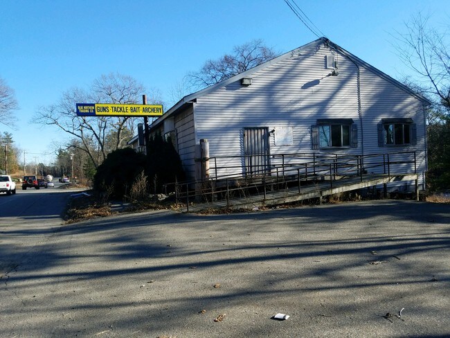
91 Littleton Rd
AYER-000036-000000-000020
Middlesex
Storebuilding
Massachusetts
A2
20
AE The base floodplain where base flood elevations are provided. AE Zones are now used on new format FIRMs instead of A1-A30 Zones.
0.75 AC
2025
Groton/Townsend
2025
Boston
325101
Boston-Cambridge-Newton, MA-NH
2,830 SF
NEARBY LISTINGS FOR SALE OR LEASE
DEMOGRAPHICS near 91 Littleton Rd
1 mile
3 mile
5 mile
2025 Total Population
3,652
17,213
41,036
2030 Population
3,841
18,016
42,823
Pop Growth 2025-2030
+ 5.18%
+ 4.67%
+ 4.35%
Average Age
41
42
43
2025 Total Households
1,516
6,669
15,332
HH Growth 2025-2030
+ 5.21%
+ 4.86%
+ 4.59%
Median Household Inc
$130,514
$127,862
$140,031
Avg Household Size
2.40
2.50
2.50
2025 Avg HH Vehicles
2.00
2.00
2.00
Median Home Value
$485,905
$603,366
$651,604
Median Year Built
1987
1979
1977
Nearby Places
Map Layers
Map Styles
 Street
 Aerial
Layers
 Traffic
 Biking
Places
Listings with unknown addresses are not visible on the map
- Restaurants
- Banks
- Shops
- Fitness
- Groceries
PUBLIC TRANSPORTATION
COMMUTER RAIL
Ayer (Fitchburg/South Acton Line - Massachusetts Bay Transportation Authority Commuter Rail (Purple Line))
Drive
Walk
Distance
Ayer (Fitchburg/South Acton Line - Massachusetts Bay Transportation Authority Commuter Rail (Purple Line))
4 min
2.0 mi
Littleton/Route 495 (Fitchburg/South Acton Line - Massachusetts Bay Transportation Authority Commuter Rail (Purple Line))
Drive
Walk
Distance
Littleton/Route 495 (Fitchburg/South Acton Line - Massachusetts Bay Transportation Authority Commuter Rail (Purple Line))
9 min
4.8 mi
AIRPORT
Manchester Boston Regional
Drive
Walk
Distance
Manchester Boston Regional
58 min
35.4 mi
General Edward Lawrence Logan International
Drive
Walk
Distance
General Edward Lawrence Logan International
56 min
35.5 mi
Worcester Regional
Drive
Walk
Distance
Worcester Regional
50 min
36.1 mi
Freight Ports
Port of Boston
Drive
Walk
Distance
Port of Boston
56 min
35.6 mi
SALE & LEASE HISTORY
LISTING DATE
SALE/LEASE

Jan 04, 2019
For Sale
Feb 26, 2020
For Sale
Apr 07, 2017
For Sale
Nearby Properties
Address
Land Use
TOTAL SIZE
Lot Size
Zoning
Address
Land Use
TOTAL SIZE
Lot Size
Zoning
329,818 SF
55 AC
A1
Address
Land Use
TOTAL SIZE
Lot Size
Zoning
337,563 SF
21.31 AC
17
Address
Land Use
TOTAL SIZE
Lot Size
Zoning
832,622 SF
43.78 AC
I
Address
Land Use
TOTAL SIZE
Lot Size
Zoning
448,759 SF
51.82 AC
IA
Address
Land Use
TOTAL SIZE
Lot Size
Zoning
481,300 SF
69.04 AC
IA
Address
Land Use
TOTAL SIZE
Lot Size
Zoning
143,640 SF
29.44 AC
IA
Address
Land Use
TOTAL SIZE
Lot Size
Zoning
51,888 SF
57.38 AC
LI
Address
Land Use
TOTAL SIZE
Lot Size
Zoning
374,270 SF
62.74 AC
IA
Address
Land Use
TOTAL SIZE
Lot Size
Zoning
398,800 SF
21.92 AC
I
Address
Land Use
TOTAL SIZE
Lot Size
Zoning
125,160 SF
29.36 AC
R
Address
Land Use
TOTAL SIZE
Lot Size
Zoning
342,309 SF
21.60 AC
I
Address
Land Use
TOTAL SIZE
Lot Size
Zoning
213,950 SF
22.71 AC
I
Address
Land Use
TOTAL SIZE
Lot Size
Zoning
293,250 SF
60.10 AC
LI
Address
Land Use
TOTAL SIZE
Lot Size
Zoning
343,400 SF
20 AC
LI
Address
Land Use
TOTAL SIZE
Lot Size
Zoning
105,559 SF
35.45 AC
A1
Address
Land Use
TOTAL SIZE
Lot Size
Zoning
216,289 SF
17.54 AC
I
Address
Land Use
TOTAL SIZE
Lot Size
Zoning
16.44 AC
IA
Address
Land Use
TOTAL SIZE
Lot Size
Zoning
162,000 SF
19.40 AC
I
Address
Land Use
TOTAL SIZE
Lot Size
Zoning
186,000 SF
16.02 AC
C
Address
Land Use
TOTAL SIZE
Lot Size
Zoning
134,920 SF
26.90 AC
I
Address
Land Use
TOTAL SIZE
Lot Size
Zoning
8.21 AC
R
Address
Land Use
TOTAL SIZE
Lot Size
Zoning
234,465 SF
16.13 AC
I
Address
Land Use
TOTAL SIZE
Lot Size
Zoning
672 SF
183.18 AC
IA
Address
Land Use
TOTAL SIZE
Lot Size
Zoning
94,159 SF
13.31 AC
I
Address
Land Use
TOTAL SIZE
Lot Size
Zoning
98,125 SF
8.97 AC
IA
Address
Land Use
TOTAL SIZE
Lot Size
Zoning
57,152 SF
20.30 AC
A2
Address
Land Use
TOTAL SIZE
Lot Size
Zoning
78,808 SF
6.38 AC
I
Address
Land Use
TOTAL SIZE
Lot Size
Zoning
108,992 SF
23.90 AC
IA
Address
Land Use
TOTAL SIZE
Lot Size
Zoning
161,597 SF
20.67 AC
IA
Address
Land Use
TOTAL SIZE
Lot Size
Zoning
140,318 SF
12.75 AC
I
The World's #1 Commercial Real Estate Marketplace
Connect with us
© 2026 CoStar Group
The information above has been obtained from sources believed reliable. While we do not doubt its accuracy we have not verified it and make no guarantee, warranty or representation about it. It is your responsibility to independently confirm its accuracy and completeness. Any projections, opinions, assumptions, or estimates used are for example only and do not represent the current or future performance of the property. The value of this transaction to you depends on tax and other factors which should be evaluated by your tax, financial, and legal advisors. You and your advisors should conduct a careful, independent investigation of the property to determine to your satisfaction the suitability of the property for your needs.