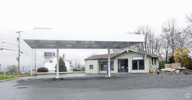
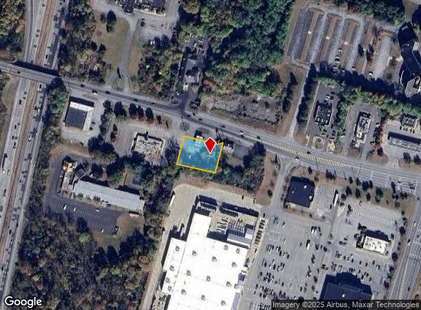
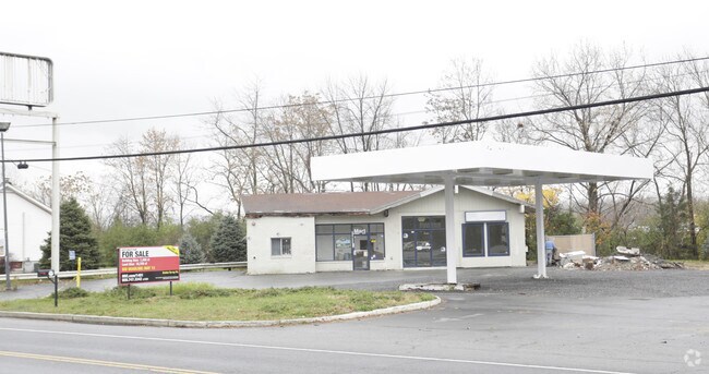
Property Record
91 Route 17K, Newburgh, NY 12550

NEARBY LISTINGS FOR SALE OR LEASE
Property Detail
91 Route 17K
334600-095-000-0001-034.000-0000
Orange
Servicestation
New York
X
34.00
36111C0900F
0.49 AC
2024
Newburgh
2024
Northern New Jersey
010400
New York-Jersey City-White Plains, NY-NJ
1,577 SF
DEMOGRAPHICS near 91 Route 17K
1 Mile
3 Mile
5 Mile
2024 Total Population
1,668
43,730
91,988
2029 Population
1,694
44,406
93,820
Pop Growth 2024-2029
+ 1.56%
+ 1.55%
+ 1.99%
Average Age
43
39
39
2024 Total Households
705
15,920
33,708
HH Growth 2024-2029
+ 1.70%
+ 1.67%
+ 2.12%
Median Household Inc
$81,208
$83,290
$83,231
Avg Household Size
2.40
2.60
2.60
2024 Avg HH Vehicles
2.00
2.00
2.00
Median Home Value
$270,085
$258,548
$295,442
Median Year Built
1973
1966
1966
Nearby Places
- Restaurants
- Banks
- Shops
- Fitness
- Groceries
PUBLIC TRANSPORTATION
COMMUTER RAIL
Beacon Station (Hudson Line - Metro-North Commuter Railroad Company (Metro-North))
DRIVE
WALK
Distance
Beacon Station (Hudson Line - Metro-North Commuter Railroad Company (Metro-North))
11 min
6.9 mi
Salisbury Mills Cornwall (Bergen County/Port Jervis Line - NJ Transit Commuter Rail (NJ Transit), Main/Port Jervis Line - NJ Transit Commuter Rail (NJ Transit))
DRIVE
WALK
Distance
Salisbury Mills Cornwall (Bergen County/Port Jervis Line - NJ Transit Commuter Rail (NJ Transit), Main/Port Jervis Line - NJ Transit Commuter Rail (NJ Transit))
14 min
7.3 mi
AIRPORT
New York Stewart International
DRIVE
WALK
Distance
New York Stewart International
9 min
4.1 mi
Freight Ports
Port Newark Container Terminal
DRIVE
WALK
Distance
Port Newark Container Terminal
89 min
67.8 mi
Nearby Properties
Address
Land Use
TOTAL SIZE
Lot Size
Zoning
Address
Land Use
TOTAL SIZE
Lot Size
Zoning
345,572 SF
43.80 AC
R-1
Address
Land Use
TOTAL SIZE
Lot Size
Zoning
88,103 SF
32.60 AC
RH
Address
Land Use
TOTAL SIZE
Lot Size
Zoning
927,041 SF
104.37 AC
Address
Land Use
TOTAL SIZE
Lot Size
Zoning
272,943 SF
17 AC
RL
Address
Land Use
TOTAL SIZE
Lot Size
Zoning
130,037 SF
128.80 AC
Address
Land Use
TOTAL SIZE
Lot Size
Zoning
176,680 SF
1.28 AC
RM
Address
Land Use
TOTAL SIZE
Lot Size
Zoning
59,220 SF
6.40 AC
CD
Address
Land Use
TOTAL SIZE
Lot Size
Zoning
50.30 AC
Address
Land Use
TOTAL SIZE
Lot Size
Zoning
8.50 AC
AP
Address
Land Use
TOTAL SIZE
Lot Size
Zoning
660.70 AC
AP
Address
Land Use
TOTAL SIZE
Lot Size
Zoning
739.80 AC
Address
Land Use
TOTAL SIZE
Lot Size
Zoning
94,608 SF
3.90 AC
RH
Address
Land Use
TOTAL SIZE
Lot Size
Zoning
71.72 AC
Address
Land Use
TOTAL SIZE
Lot Size
Zoning
44.50 AC
Address
Land Use
TOTAL SIZE
Lot Size
Zoning
505,577 SF
50.50 AC
Address
Land Use
TOTAL SIZE
Lot Size
Zoning
265,660 SF
24.20 AC
Address
Land Use
TOTAL SIZE
Lot Size
Zoning
229,085 SF
30.90 AC
04
Address
Land Use
TOTAL SIZE
Lot Size
Zoning
110,686 SF
6.50 AC
RH
Address
Land Use
TOTAL SIZE
Lot Size
Zoning
29,935 SF
31.60 AC
04
Address
Land Use
TOTAL SIZE
Lot Size
Zoning
185,409 SF
26.10 AC
Address
Land Use
TOTAL SIZE
Lot Size
Zoning
67,448 SF
6.30 AC
RL
Address
Land Use
TOTAL SIZE
Lot Size
Zoning
90,584 SF
2.60 AC
RH
Address
Land Use
TOTAL SIZE
Lot Size
Zoning
71,379 SF
20.80 AC
Address
Land Use
TOTAL SIZE
Lot Size
Zoning
200,000 SF
13.80 AC
CD
Address
Land Use
TOTAL SIZE
Lot Size
Zoning
97,011 SF
19.70 AC
Address
Land Use
TOTAL SIZE
Lot Size
Zoning
51,264 SF
1.35 AC
BC
Address
Land Use
TOTAL SIZE
Lot Size
Zoning
20.90 AC
Address
Land Use
TOTAL SIZE
Lot Size
Zoning
115,361 SF
17.70 AC
IND
Address
Land Use
TOTAL SIZE
Lot Size
Zoning
73,585 SF
5.60 AC
04
Address
Land Use
TOTAL SIZE
Lot Size
Zoning
10.30 AC
The World's #1 Commercial Real Estate Marketplace
Connect with us
© 2025 CoStar Group
The information above has been obtained from sources believed reliable. While we do not doubt its accuracy we have not verified it and make no guarantee, warranty or representation about it. It is your responsibility to independently confirm its accuracy and completeness. Any projections, opinions, assumptions, or estimates used are for example only and do not represent the current or future performance of the property. The value of this transaction to you depends on tax and other factors which should be evaluated by your tax, financial, and legal advisors. You and your advisors should conduct a careful, independent investigation of the property to determine to your satisfaction the suitability of the property for your needs.