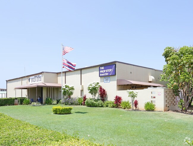
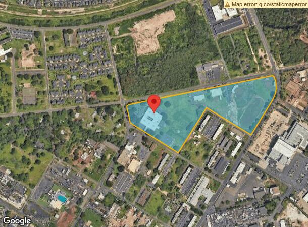
Property Record
91 Shangrila St, Kapolei, HI 96707

NEARBY LISTINGS FOR SALE OR LEASE
Property Detail
91 Shangrila St
1-9-1-013-022-0000
LOT 1 F P 2555 26.270 AC SUBJ/ESMTS
Commercialnec
Honolulu
D
Hawaii
15003C0310G
1
2025
26.27 AC
2025
West Oahu
008502
Hawaii
75,866 SF
Urban Honolulu, HI
DEMOGRAPHICS near 91 Shangrila St
1 Mile
3 Mile
5 Mile
2024 Total Population
12,516
63,277
103,927
2029 Population
12,240
60,656
99,382
Pop Growth 2024-2029
(2.21%)
(4.14%)
(4.37%)
Average Age
34
36
37
2024 Total Households
3,755
18,573
29,793
HH Growth 2024-2029
(2.42%)
(4.59%)
(4.83%)
Median Household Inc
$112,827
$111,447
$113,534
Avg Household Size
3.10
3.20
3.30
2024 Avg HH Vehicles
2.00
2.00
2.00
Median Home Value
$695,552
$716,702
$727,081
Median Year Built
2009
2002
1999
Nearby Places
Map Layers
Map Styles
 Street
 Aerial
- Restaurants
- Banks
- Shops
- Fitness
- Groceries
PUBLIC TRANSPORTATION
AIRPORT
Daniel K Inouye International
DRIVE
WALK
Distance
Daniel K Inouye International
27 min
18.1 mi
Freight Ports
Honolulu Harbor, Oahu
DRIVE
WALK
Distance
Honolulu Harbor, Oahu
35 min
22.3 mi
Nearby Properties
Address
Land Use
TOTAL SIZE
Lot Size
Zoning
Address
Land Use
TOTAL SIZE
Lot Size
Zoning
736 AC
F-1
Address
Land Use
TOTAL SIZE
Lot Size
Zoning
310,432 SF
192.56 AC
BMX-3
Address
Land Use
TOTAL SIZE
Lot Size
Zoning
645,869 SF
48.95 AC
AG-1
Address
Land Use
TOTAL SIZE
Lot Size
Zoning
80,641 SF
227.76 AC
I-2
Address
Land Use
TOTAL SIZE
Lot Size
Zoning
222.44 AC
I-3
Address
Land Use
TOTAL SIZE
Lot Size
Zoning
139.30 AC
F-1
Address
Land Use
TOTAL SIZE
Lot Size
Zoning
222.34 AC
I-3
Address
Land Use
TOTAL SIZE
Lot Size
Zoning
48.66 AC
I-2
Address
Land Use
TOTAL SIZE
Lot Size
Zoning
61,643 SF
116.66 AC
I-2
Address
Land Use
TOTAL SIZE
Lot Size
Zoning
307,171 SF
24.64 AC
I-2
Address
Land Use
TOTAL SIZE
Lot Size
Zoning
229,396 SF
11.31 AC
BMX-3
Address
Land Use
TOTAL SIZE
Lot Size
Zoning
2,225 SF
19.72 AC
AG-1
Address
Land Use
TOTAL SIZE
Lot Size
Zoning
46.69 AC
BMX-3
Address
Land Use
TOTAL SIZE
Lot Size
Zoning
334.93 AC
U/42/40
Address
Land Use
TOTAL SIZE
Lot Size
Zoning
222,228 SF
7.15 AC
B-2
Address
Land Use
TOTAL SIZE
Lot Size
Zoning
183,343 SF
15.27 AC
BMX-3
Address
Land Use
TOTAL SIZE
Lot Size
Zoning
149,923 SF
13.35 AC
BMX-3
Address
Land Use
TOTAL SIZE
Lot Size
Zoning
67.18 AC
U/51/50
Address
Land Use
TOTAL SIZE
Lot Size
Zoning
45.60 AC
F-1
Address
Land Use
TOTAL SIZE
Lot Size
Zoning
238,418 SF
9.46 AC
F-1
Address
Land Use
TOTAL SIZE
Lot Size
Zoning
218,926 SF
11.87 AC
I-2
Address
Land Use
TOTAL SIZE
Lot Size
Zoning
158,113 SF
21.79 AC
B-2
Address
Land Use
TOTAL SIZE
Lot Size
Zoning
226,260 SF
7.10 AC
I-2
Address
Land Use
TOTAL SIZE
Lot Size
Zoning
1,714 SF
200.33 AC
AG-1
Address
Land Use
TOTAL SIZE
Lot Size
Zoning
63,936 SF
62.24 AC
F-1
Address
Land Use
TOTAL SIZE
Lot Size
Zoning
208,386 SF
2.84 AC
B-2
Address
Land Use
TOTAL SIZE
Lot Size
Zoning
139,755 SF
18.79 AC
B-2
Address
Land Use
TOTAL SIZE
Lot Size
Zoning
1,068,018 SF
11.54 AC
B-2
Address
Land Use
TOTAL SIZE
Lot Size
Zoning
477,333 SF
17.76 AC
BMX-3
The World's #1 Commercial Real Estate Marketplace
Connect with us
© 2026 CoStar Group
The information above has been obtained from sources believed reliable. While we do not doubt its accuracy we have not verified it and make no guarantee, warranty or representation about it. It is your responsibility to independently confirm its accuracy and completeness. Any projections, opinions, assumptions, or estimates used are for example only and do not represent the current or future performance of the property. The value of this transaction to you depends on tax and other factors which should be evaluated by your tax, financial, and legal advisors. You and your advisors should conduct a careful, independent investigation of the property to determine to your satisfaction the suitability of the property for your needs.