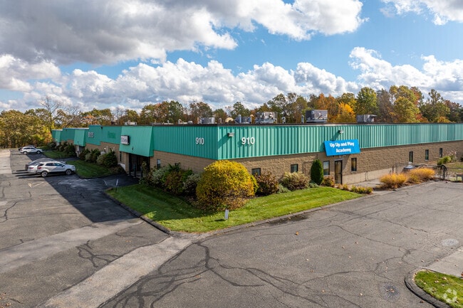
Property Record
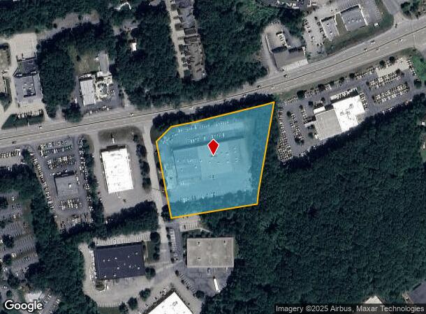
910 Boston Tpke, Shrewsbury, MA 01545

Current Lease Availabilities
NEARBY LISTINGS FOR SALE OR LEASE
Property Detail
910 Boston Tpke
Manufacturinglight
Worcester
X
Massachusetts
25027C0643F
3.79 AC
2025
The Boroughs
2025
Boston
739102
Worcester, MA-CT
37,800 SF
SHRE-000036-000000-031006
DEMOGRAPHICS near 910 Boston Tpke
1 Mile
3 Mile
5 Mile
2024 Total Population
7,160
41,246
111,697
2029 Population
7,190
41,464
111,888
Pop Growth 2024-2029
+ 0.42%
+ 0.53%
+ 0.17%
Average Age
38
40
41
2024 Total Households
2,570
15,154
43,079
HH Growth 2024-2029
+ 0.43%
+ 0.63%
+ 0.20%
Median Household Inc
$141,826
$131,124
$110,170
Avg Household Size
2.70
2.70
2.50
2024 Avg HH Vehicles
2.00
2.00
2.00
Median Home Value
$588,052
$526,644
$471,201
Median Year Built
1990
1982
1977
Nearby Places
Map Layers
Map Styles
 Street
 Aerial
- Restaurants
- Banks
- Shops
- Fitness
- Groceries
PUBLIC TRANSPORTATION
COMMUTER RAIL
Westborough (Framingham/Worcester Line - Massachusetts Bay Transportation Authority Commuter Rail (Purple Line))
DRIVE
WALK
Distance
Westborough (Framingham/Worcester Line - Massachusetts Bay Transportation Authority Commuter Rail (Purple Line))
6 min
2.9 mi
Grafton (Framingham/Worcester Line - Massachusetts Bay Transportation Authority Commuter Rail (Purple Line))
DRIVE
WALK
Distance
Grafton (Framingham/Worcester Line - Massachusetts Bay Transportation Authority Commuter Rail (Purple Line))
7 min
3.4 mi
AIRPORT
Worcester Regional
DRIVE
WALK
Distance
Worcester Regional
25 min
12.5 mi
General Edward Lawrence Logan International
DRIVE
WALK
Distance
General Edward Lawrence Logan International
54 min
38.0 mi
Nearby Properties
Address
Land Use
TOTAL SIZE
Lot Size
Zoning
Address
Land Use
TOTAL SIZE
Lot Size
Zoning
42.01 AC
I
Address
Land Use
TOTAL SIZE
Lot Size
Zoning
68.85 AC
OFF-RE
Address
Land Use
TOTAL SIZE
Lot Size
Zoning
22.40 AC
COM BU
Address
Land Use
TOTAL SIZE
Lot Size
Zoning
67.29 AC
IB
Address
Land Use
TOTAL SIZE
Lot Size
Zoning
23.65 AC
RUR A
Address
Land Use
TOTAL SIZE
Lot Size
Zoning
19.69 AC
BA
Address
Land Use
TOTAL SIZE
Lot Size
Zoning
375.66 AC
OLI
Address
Land Use
TOTAL SIZE
Lot Size
Zoning
205,712 SF
3.95 AC
BA
Address
Land Use
TOTAL SIZE
Lot Size
Zoning
201,818 SF
5.55 AC
BA
Address
Land Use
TOTAL SIZE
Lot Size
Zoning
205,712 SF
5.76 AC
BA
Address
Land Use
TOTAL SIZE
Lot Size
Zoning
107,308 SF
45.40 AC
M-1
Address
Land Use
TOTAL SIZE
Lot Size
Zoning
412,272 SF
42.44 AC
OFF-RE
Address
Land Use
TOTAL SIZE
Lot Size
Zoning
142,438 SF
14.26 AC
RES B-
Address
Land Use
TOTAL SIZE
Lot Size
Zoning
43.90 AC
M-1
Address
Land Use
TOTAL SIZE
Lot Size
Zoning
21.04 AC
APT 99
Address
Land Use
TOTAL SIZE
Lot Size
Zoning
174,807 SF
32.43 AC
RES B-
Address
Land Use
TOTAL SIZE
Lot Size
Zoning
203,184 SF
0.21 AC
MF-1
Address
Land Use
TOTAL SIZE
Lot Size
Zoning
10.28 AC
R
Address
Land Use
TOTAL SIZE
Lot Size
Zoning
9.70 AC
COM BU
Address
Land Use
TOTAL SIZE
Lot Size
Zoning
0.99 AC
MF-1 9
Address
Land Use
TOTAL SIZE
Lot Size
Zoning
134,896 SF
15.10 AC
LIM IN
Address
Land Use
TOTAL SIZE
Lot Size
Zoning
170,000 SF
27.66 AC
BA
Address
Land Use
TOTAL SIZE
Lot Size
Zoning
99,908 SF
18.28 AC
RUR AA
Address
Land Use
TOTAL SIZE
Lot Size
Zoning
102,181 SF
38.62 AC
RES B-
Address
Land Use
TOTAL SIZE
Lot Size
Zoning
108,038 SF
19.68 AC
M-1
Address
Land Use
TOTAL SIZE
Lot Size
Zoning
15.26 AC
COM BU
Address
Land Use
TOTAL SIZE
Lot Size
Zoning
12.96 AC
MF-1
Address
Land Use
TOTAL SIZE
Lot Size
Zoning
10.34 AC
APT 91
Address
Land Use
TOTAL SIZE
Lot Size
Zoning
125,914 SF
111.02 AC
Address
Land Use
TOTAL SIZE
Lot Size
Zoning
19.05 AC
I
The World's #1 Commercial Real Estate Marketplace
Connect with us
© 2025 CoStar Group
The information above has been obtained from sources believed reliable. While we do not doubt its accuracy we have not verified it and make no guarantee, warranty or representation about it. It is your responsibility to independently confirm its accuracy and completeness. Any projections, opinions, assumptions, or estimates used are for example only and do not represent the current or future performance of the property. The value of this transaction to you depends on tax and other factors which should be evaluated by your tax, financial, and legal advisors. You and your advisors should conduct a careful, independent investigation of the property to determine to your satisfaction the suitability of the property for your needs.